
Archived information
The Standard on Web Usability replaces this content. This content is archived because Common Look and Feel 2.0 Standards have been rescinded.
Archived information is provided for reference, research or recordkeeping purposes. It is not subject to the Government of Canada Web Standards and has not been altered or updated since it was archived.
NOTICES TO MARINERS
PUBLICATION
WESTERN EDITION
Safety First, Service Always
Published Monthly by the
CANADIAN COAST GUARD
www.notmar.gc.ca/subscribe/
CONTENTS
| Section 1 | General and Safety Information |
| Section 2 | Chart Corrections |
| Section 3 | Radio Aids to Marine Navigation Corrections |
| Section 4 | Sailing Directions and Small Craft Guide Corrections |
| Section 5 | List of Lights, Buoys and Fog Signals Corrections |
Canadian Coast Guard Programs
Aids to Navigation and Waterways
Fisheries and Oceans Canada
Montreal, Quebec
H2Y 2E7
© Her Majesty the Queen in Right of Canada, 2017
DFO/2017-2003
Fs152-6E-PDF
ISSN 1719-7708
Disponible en français :
Publication des Avis aux navigateurs
Édition de l'Ouest
Édition mensuelle Nº03/2017
Fisheries and Oceans Canada
Official Publication of the Canadian Coast Guard
DFO/2018-2003
EXPLANATORY NOTES
Geographical positions refer directly to the graduations of the largest scale Canadian Hydrographic chart unless otherwise indicated.
Bearings refer to the true compass and are measured clockwise from 000° (North) clockwise to 359°; those relating to lights are from seaward.
Visibility of lights is that in clear weather.
Depths - The units used for soundings (metres, fathoms or feet) are stated in the title of each chart.
Elevations are normally given above Higher High Water, Large Tide unless otherwise indicated.
Distances may be calculated as follows:
1 nautical mile = 1,852 metres (6,076.1 feet)
1 statute mile = 1,609.3 metres (5,280 feet)
1 metre = 3.28 feet
Temporary & Preliminary Notices are indicated by a (T) or a (P) in Section 1, respectively. Please note that Nautical charts are not amended by the Canadian Hydrographic Service for Temporary (T) and Preliminary (P) Notices. It is recommended that mariners chart these corrections in pencil. The list of charts affected by Temporary and Preliminary Notices are revised and promulgated quarterly in Section 1 of the Monthly Edition.
Please note that, in addition to the temporary and preliminary changes normally advertised as (T) and (P) Notices, there are a few permanent changes to aids to navigation that have been advertised as Preliminary Notices to Mariners while charts are being updated for new editions.
Marine Information Report & Suggestion Sheet
Mariners are requested to notify the responsible authorities when new or suspected dangers to navigation are discovered, changes observed in aids to navigation or corrections to publications are seen
to be necessary. Such communications can be made using the Marine Information Report & Suggestion Sheet inserted on the last
page of each monthly edition of Notices to Mariners.
Canadian Hydrographic Service - Information Published in Section 2 of Notices to Mariners
Mariners are advised that only the most critical changes that directly affect safety to navigation are issued in Section 2 – Chart Corrections. This limitation
is required to ensure that charts remain as clear and easy to read as possible. As a result, mariners may see minor discrepancies of a
non-critical nature between information in official publications. For example, a small change in the nominal range or focal height of a light
may not result in the production of a chart correction in Notices to Mariners, but may result in a correction in the List of Lights, Buoys and
Fog Signals publication.
In case of discrepancy between information provided on CHS charts relating to aids to navigation, and the List of Lights, Buoys and Fog Signals publication, the latter shall be deemed as containing the most up-to-date information.
Canadian Nautical Charts & Publications
A source list of Canadian nautical charts and publications is published in Notice No. 14 of the Notices to Mariners Annual Edition 2018. The source supply and the prices
effective at the time of printing are listed. For current chart edition dates, please refer to the following website:
www.chs-shc.gc.ca/charts-cartes/paper-papier/index-eng.asp
CHART CORRECTIONS - SECTION 2
Corrections to nautical charts will be listed in numerical order by chart number. Each chart correction listed applies only to that particular chart. Related charts, if any, will have their own specific correction listed separately.
Users should also refer to CHS Chart 1: Symbols, Abbreviations and Terms for additional information pertaining to the correction of charts.
The illustration below describes the elements that will comprise a typical Section 2 chart correction:
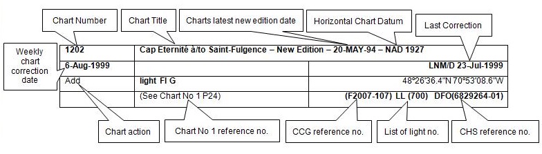
The last correction number is identified with the LNM/D or Last Notice to Mariners Number / Date.
NOTICES TO MARINERS WEBSITE – MONTHLY EDITIONS, CHART CORRECTIONS, AND CHART PATCHES
The Notices to Mariners website allows users to access the monthly publications,
chart corrections, and chart patches.
Users can subscribe for free to the email notification service
to receive notifications when charts of interest are updated, including their patches, as well as when a new monthly edition becomes available online.
ADVISORY NOTICES TO SHIPPING (BROADCAST AND WRITTEN)
The Canadian Coast Guard is implementing a number of changes to the aids to navigation system in Canada.
These changes are advertised as Notices to Shipping (Broadcast and Written) by the Canadian Coast Guard, and are then followed up with Notices to Mariners, then charts are updated by hand correction, reprints or new editions.
Mariners are advised that all relevant Written Notices to Shipping should be kept until superseded by Notices to Mariners or through revised charts issued by the Canadian Hydrographic Service (CHS).
Written Notices to Shipping are available on the Canadian Coast Guard website at: www.ccg-gcc.gc.ca/eng/CCG/NOTSHIP.
The Canadian Hydrographic Service is reviewing the impact of these changes with the Canadian Coast Guard and together are preparing an action plan on the issuing of chart revisions.
For further information, contact your local Regional Notices to Shipping (NOTSHIP) issuing authorities.
Western
MCTS Western Regional Office
Canadian Coast Guard
Institute of Ocean Sciences
P.O. Box 6000
9860 West Saanich Rd.
Sidney, BC V8L 4B2
Telephone: (250) 363-8904 (Regional Administrative Assistant)
Email: NOTSHIP.Western@innav.gc.ca
* Iqaluit MCTS Centre
Operational from approximately mid-May until late December.
Canadian Coast Guard
P.O. Box 189
Iqaluit, NU X0A 0H0
“A” Series NOTSHIPs
Telephone: (867) 979-5269
Facsimile: (867) 979-4264
Email: IqaNordreg@innav.gc.ca
Website:
http://www.ccg-gcc.gc.ca/eng/CCG/Notship-Home
“H” Series NOTSHIPs
Telephone: (867) 979-0310
Facsimile: (867) 979-4264
Email: Iqamck01@innav.gc.ca
Website:
http://www.ccg-gcc.gc.ca/eng/CCG/Notship-Home
* Service available in English and French.
Index
NUMERICAL INDEX OF CANADIAN CHARTS AFFECTED
| 1350 | 3554 | 6258 | 7072 |
| 1351 | 3555 | 6259 | 7135 |
| 3061 | 3671 | 6263 | 7170 |
| 3312 | 3724 | 6272 | 7185 |
| 3313 | 3737 | 7051 | 7193 |
| 3419 | 3982 | 7052 | 7465 |
| 3424 | 4276 | 7053 | 7487 |
| 3440 | 4363 | 7065 | 7600 |
| 3543 | 5451 | 7066 | 7620 |
| 3548 | 6218 | 7067 |
SECTION 1 - GENERAL AND SAFETY INFORMATION
CANADIAN HYDROGRAPHIC SERVICE - ANNOUNCEMENT REGARDING CANADIAN HYDROGRAPHIC SERVICE CHART PATCHES
Colour Web Patches are free to the mariner, and given the quality of many printers, should reproduce well.
They will be available in real time all around the world.
CHS welcomes your feedback on this service at chsinfo@dfo-mpo.gc.ca.
CANADIAN HYDROGRAPHIC SERVICE - CUMULATIVE CHART CORRECTIONS
The cumulative Notices to Mariners corrections for charts can now be accessed at
http://www.notmar.gc.ca/corrections-en.php.
CANADIAN HYDROGRAPHIC SERVICE - CURRENT CHART EDITION DATES
CHART EDITIONS
The three terms described below are used to indicate the publication status of Canadian charts.
NEW CHART - "NEWCHT"
The first publication of a Canadian chart embracing an area not previously charted to the scale shown, or embracing an area different from any existing Canadian chart.
NEW EDITION - "NEWEDT"
A new issue of an existing chart containing amendments essential to navigation in addition to those issued in Notices to Mariners and making existing editions obsolete.
REPRINTS
A new issue of the current edition of a chart incorporating no amendments of navigational significance other than those previously promulgated in Notices to Mariners. It may also contain amendments from other sources provided they are not essential to navigation. Previous printings of the current edition remain in force.
The current chart edition dates can be accessed at www.chs-shc.gc.ca/charts-cartes/paper-papier/index-eng.asp
CANADIAN HYDROGRAPHIC SERVICE - PRINT ON DEMAND CHARTS - CARE AND USE
Background
By providing nautical charts to the public, the goal of the Canadian Hydrographic Service (CHS) is to provide services for safe navigation in a fiscally responsible manner. As a result, CHS continues to expand its portfolio of nautical paper charts that are printed using Print On Demand (POD) technology. These charts are easily recognized by their whiter paper and the coloured logo of the Canadian Hydrographic Service. This new technology enables CHS to print charts in a more efficient manner while enhancing chart content through being able to quickly add new and important information. POD technology provides customers with up-to-date charts without the historical hand-drawn corrections or glued-on patches. Additionally, this technology eliminates out-of-stock situations which arise with the traditional printing and warehousing methods. In the event of a national emergency, CHS can respond to the appropriate authorities with best available information very quickly.
Care of Your POD Chart
CHS encourages its customers to handle the POD charts more carefully than the traditional lithographic charts. When plotting information on POD charts, use HB pencils and apply limited pressure. Testing has suggested that an Indian gum eraser is more effective than alternatives when used on the product. This eraser is also suitable for charts printed using lithographic processes.
CANADIAN HYDROGRAPHIC SERVICE, TRANSPORT CANADA - NAVIGATION SAFETY - ECDIS
Mariners are advised that ECDIS may not display some isolated shoal depths when operating in "base or standard display" mode. Route planning and monitoring alarms for these shoal depths may not always be activated. To ensure safe navigation and to confirm that a planned route is clear of such dangers, mariners should visually inspect the planned route and any deviations from it using ECDIS configured to display "all data". The automated voyage planning check function should not be solely relied upon.
*301 CANADIAN HYDROGRAPHIC SERVICE – NAUTICAL CHARTS
| CHARTS | MAIN TITLE | SCALE | PUBLISHED | CAT # | PRICE | |
|---|---|---|---|---|---|---|
| New Charts | ||||||
| 3554 | Plans Desolation Sound | 1:12000 | 06-JAN-2017 | 2 | 20.00 | |
| New Editions | ||||||
| 1350 | Sorel-Tracy à/to Otterburn-Park | 1:15000 | 04-NOV-2016 | 1, 3 | 28.00 | |
| 1351 | Bassin de Chambly au lac/to Lake Champlain | 1:15000 | 18-NOV-2016 | 1, 3 | 28.00 | |
| 4276 | Little Bras D'or | 1:5000 | 24-FEB-2017 | 1 | 20.00 | |
| 4363 | Cape Smoky to / à St Paul Island | 1:75000 | 24-FEB-2017 | 1 | 20.00 | |
| 5451 | Cape Dorset and Approaches/et les Approches | 1:25000 | 29-MAY-2015 | 4 | 20.00 | |
| 7052 | Cape Mercy to/à Kangeeak Point | 1:500000 | 25-MAR-2016 | 4 | 20.00 | |
| 7072 | Kane Basin to/à Lincoln Sea | 1:500000 | 29-MAY-2015 | 4 | 20.00 | |
| 7135 | Brevoort Harbour | 1:12000 | 25-MAR-2016 | 4 | 20.00 | |
| 7185 | Kangeeak Point and Approaches/et les Approches | 1:50000 | 25-MAR-2016 | 4 | 20.00 | |
| 7193 | Cape Hooper and Approaches/et les Approches | 1:60000 | 25-MAR-2016 | 4 | 20.00 | |
| 7465 | Frustration Bay and Approaches/et les Approches | 1:25000 | 25-MAR-2016 | 4 | 20.00 | |
| Charts Permanently Withdrawn | ||||||
| 3555 | Plans - Vicinity of/Proximité de Redonda Islands and/et Loughborough Inlet | |||||
*302 CANADIAN HYDROGRAPHIC SERVICE – ELECTRONIC NAVIGATIONAL CHARTS
| S-57 ENC NUMBER | CHART TITLE |
|---|---|
| NEW PRODUCTS | |
| CA570420 | Tenedos Bay |
| CA570422 | Walsh Cove |
| CA570709 | Refuge Cove |
| CA570710 | Squirrel Cove |
| CA570712 | Prideaux Haven |
| CA570727 | Cortes Bay |
| CA570728 | Lund |
| CA570729 | Roscoe Bay |
| CA576353 | Spanish Bay to Little Bras D'Or Channel |
| CA576354 | Little Bras D'Or to/a St Andrew's Channel |
| WITHDRAWN PRODUCTS | |
| CA579059 | Black Cape |
*303 TRANSPORT CANADA – SHIP SAFETY BULLETIN
This is to notify you that a new Ship Safety Bulletin
has recently been posted to the Transport Canada website at www.tc.gc.ca/ssb-bsn/.
To go online to view or download this bulletin, please click on the link below:
SSB#04/2017
– Coming into force of the new Vessel Fire Safety Regulations
RDIMS#12151494
Sign yourself up for e-Bulletin to receive an e-mail notice each time a new Ship Safety Bulletin is published on our Website.
Contact us at : marinesafety-securitemaritime@tc.gc.ca or 1-855-859-3123 (Toll Free).
*304 TRANSPORT CANADA – SHIP SAFETY BULLETIN
This is to notify you that a new Ship Safety Bulletin
has recently been posted to the Transport Canada website at www.tc.gc.ca/ssb-bsn/.
To go online to view or download this bulletin, please click on the link below:
SSB#05/2017
Update on how to meet STCW 2010 Manila Convention Requirements for Officers and Ratings of the Engine Department
RDIMS#12399853
Sign yourself up for e-Bulletin to receive an e-mail notice each time a new Ship Safety Bulletin is published on our Website.
Contact us at : marinesafety-securitemaritime@tc.gc.ca or 1-855-859-3123 (Toll Free).
*305 CANADIAN COAST GUARD PUBLICATION – ANNUAL EDITION OF NOTICES TO MARINERS 2017
The Annual Edition of Notices to Mariners 2017 is now available for free download, on the NOTMAR website at
https://www.notmar.gc.ca/annual-annuel-en.php.
Paper copies of this publication will no longer be sold. This printable online version is always up-to-date.
Amendments to this publication are advertised in Section 1 of the monthly editions of Notices to Mariners
(https://www.notmar.gc.ca/monthly-mensuel-en.php).
The 2017 edition has been revised up to March 31st, 2017 and supersedes the 2016 edition.
*306 CANADIAN HYDROGRAPHIC SERVICE – NEW EDITION OF CHARTS
The following New Editions have been released to comply with the government of Canada’s official languages requirements. The information on these charts has only been updated for Notices to Mariners up to the date of publication.
| CHART | CHART TITLE |
|---|---|
| 5451 | Cape Dorset and Approaches/et les Approches |
| 7051 | Cumberland Sound |
| 7052 | Cape Mercy to/à Kangeeak Point |
| 7053 | Paallavvik to/à Kangiqtugaapik |
| 7065 | Mill Island to/à Winter Island |
| 7066 | Cape Dorchester to/à Spicer Islands |
| 7067 | Spicer Islands to West Entrance of/ à L'Entrée Ouest de Fury and/et Hecla Strait |
| 7072 | Kane Basin to/à Lincoln Sea |
| 7135 | Brevoort Harbour |
| 7170 | Exeter Bay and Approaches/et les Approches |
| 7185 | Kangeeak Point and Approaches/et les Approches |
| 7193 | Cape Hooper and Approaches/et les Approches |
| 7465 | Frustration Bay and Approaches/et les Approches |
*307 KENORA, RAT PORTAGE BAY – AMENDMENTS TO SPAR BUOYS
Reference Chart: 6218
The following spar buoys have been amended:
Keewatin Channel West Entrance K36 (LL 6389) (49º 43’ 01.1’’N 094º 31’ 43.3’’W):
Changed from a red starboard spar buoy to a red starboard conical buoy
West Keewatin Channel K35 (LL 6399) (49º 43’ 02.9’’N 094º 31’ 45.0’’W):
Changed from a green port spar buoy to a green port can buoy
(D2016-022, 023)
*308 PLAYGREEN LAKE TO/AU LITTLE PLAYGREEN LAKE – UNLIT BUOY REPOSITIONED
Reference Chart: 6263
The following unlit buoy has been repositioned:
Playgreen Lake spar buoy PP4 (LL 9749) has been moved from 53º 54’ 34.4’’N 097º 57’ 34.2’’W to 53º 54’ 35.4’’N 097º 57’ 35.9’’W.
(A2017-003)
*322 APPROACHES TO/APPROCHES À OAK BAY – DAYBEACON REPLACED BY CARDINAL BUOY
Reference: Notice 928(P)/16 is cancelled (Chart 3424).
(P2017-002, 003)
SECTION 2 - CHART CORRECTIONS
3061 - Long Island to/à Little Harrison Lake - Sheet/Feuille 2 - New Edition - 29-OCT-1999 - NAD 1983
| 17-MAR-2017 | LNM/D. 27-JUL-2007 | ||
| Add | submarine cable area (See Chart No. 1, L30.2) | between 49°38′03.1″N 121°54′08.6″W and 49°37′07.4″N 121°56′48.2″W | |
| DFO(6203455-01) | |||
| Add | submarine cable area (See Chart No. 1, L30.2) | between 49°36′57.0″N 121°56′34.3″W and 49°37′52.3″N 121°53′57.8″W | |
| DFO(6203455-02) |
3312 - Secret Bay - Sheet/Feuille 4 - New Edition - 05-JAN-2007 - NAD 1983
| 24-MAR-2017 | LNM/D. 08-APR-2016 | ||
| Delete | private starboard hand daybeacon (See Chart No. 1, Qt) | 49°45′04.4″N 123°55′31.7″W | |
| DFO(6203457-01) |
3312 - Cordero Channel - East/Est - Sheet/Feuille 26 - New Edition - 05-JAN-2007 - NAD 1983
| 31-MAR-2017 | LNM/D. 24-MAR-2017 | ||
| Add | offshore platform with legend Underwater Turbine/Turbine sous-marine (See Chart No. 1, P2) This notice affects Electronic Navigational Chart: CA470019, CA570020 | 50°24′28.9″N 125°11′42.1″W | |
| DFO(6203459-01) | |||
| Add | light Fl Y, marked Priv (See Chart No. 1, P1) This notice affects Electronic Navigational Chart: CA470019, CA570020 | 50°24′28.9″N 125°11′42.1″W | |
| DFO(6203459-02) | |||
| Add | submarine cable (See Chart No. 1, L30.1) This notice affects Electronic Navigational Chart: CA470019, CA570020 | joining 50°24′34.0″N 125°11′07.7″W 50°24′32.0″N 125°11′27.0″W 50°24′31.3″N 125°11′37.8″W and 50°24′29.2″N 125°11′41.6″W | |
| DFO(6203459-03) |
3313 - Oak Bay - Sheet/Feuille 3 - New Edition - 02-JAN-2009 - NAD 1983
| 03-MAR-2017 | LNM/D. 29-JUL-2016 | ||
| Delete | port hand daybeacon and radar reflector (See Chart No. 1, Qt,S4) This notice affects Electronic Navigational Chart: CA470075, CA570214 | 48°25′28.6″N 123°17′22.4″W | |
| (P2017003) DFO(6203452-01) | |||
| Add | black and yellow North cardinal pillar buoy, marked VJ (See Chart No. 1, Q130.3) This notice affects Electronic Navigational Chart: CA470075, CA570214 | 48°25′30.6″N 123°17′23.4″W | |
| (P2017002) DFO(6203452-02) |
3313 - Approaches to/Approches à Victoria - Sheet/Feuille 4 - New Edition - 02-JAN-2009 - NAD 1983
| 03-MAR-2017 | LNM/D. 29-JUL-2016 | ||
| Delete | port hand daybeacon and radar reflector (See Chart No. 1, Qt,S4) This notice affects Electronic Navigational Chart: CA470075, CA570214 | 48°25′28.6″N 123°17′22.4″W | |
| (P2017003) DFO(6203452-01) | |||
| Add | black and yellow North cardinal pillar buoy, marked VJ (See Chart No. 1, Q130.3) This notice affects Electronic Navigational Chart: CA470075, CA570214 | 48°25′30.6″N 123°17′23.4″W | |
| (P2017002) DFO(6203452-02) | |||
| 31-MAR-2017 | LNM/D. 03-MAR-2017 | ||
| Add | floating breakwater, Bkw (See Chart No. 1, F4.1) This notice affects Electronic Navigational Chart: CA470075, CA570138 | between 48°26′16.6″N 123°26′46.9″W and 48°26′19.7″N 123°26′43.2″W | |
| DFO(6203460-01) | |||
| Delete | depth of 7.5 metres (See Chart No. 1, I10) | 48°26′20.0″N 123°26′47.0″W | |
| DFO(6203460-06) |
3419 - Esquimalt Harbour - New Edition - 13-DEC-2013 - World Geodetic System 1984
| 17-MAR-2017 | LNM/D. 20-NOV-2015 | ||
| Amend | Fl R 6m to read Fl R 7m against light (See Chart No. 1, P1) This notice affects Electronic Navigational Chart: CA470075, CA570138 | 48°25′34.2″N 123°26′19.8″W | |
| (P2017004) LL(196) DFO(6203453-01) | |||
| 31-MAR-2017 | LNM/D. 17-MAR-2017 | ||
| Add | floating breakwater, Bkw (See Chart No. 1, F4.1) This notice affects Electronic Navigational Chart: CA470075, CA570138 | joining 48°26′16.5″N 123°26′46.7″W 48°26′19.6″N 123°26′43.0″W 48°26′19.8″N 123°26′43.4″W 48°26′16.7″N 123°26′47.0″W and 48°26′16.5″N 123°26′46.7″W | |
| DFO(6203460-01) | |||
| Add | light Fl Y (See Chart No. 1, P1) This notice affects Electronic Navigational Chart: CA570138 | 48°26′16.6″N 123°26′46.8″W | |
| DFO(6203460-02) | |||
| Add | light Fl Y (See Chart No. 1, P1) This notice affects Electronic Navigational Chart: CA570138 | 48°26′17.6″N 123°26′45.6″W | |
| DFO(6203460-03) | |||
| Add | light Fl Y (See Chart No. 1, P1) This notice affects Electronic Navigational Chart: CA570138 | 48°26′18.7″N 123°26′44.4″W | |
| DFO(6203460-04) | |||
| Add | light Fl Y (See Chart No. 1, P1) This notice affects Electronic Navigational Chart: CA570138 | 48°26′19.7″N 123°26′43.3″W | |
| DFO(6203460-05) |
3424 - Approaches to/Approches à Oak Bay - New Edition - 12-SEP-2003 - NAD 1983
| 03-MAR-2017 | LNM/D. 18-SEP-2015 | ||
| Delete | port hand daybeacon (See Chart No. 1, Qt) This notice affects Electronic Navigational Chart: CA470075, CA570214 | 48°25′28.6″N 123°17′22.4″W | |
| (P2017003) DFO(6203452-01) | |||
| Add | black and yellow North cardinal pillar buoy, marked VJ (See Chart No. 1, Q130.3) This notice affects Electronic Navigational Chart: CA470075, CA570214 | 48°25′30.6″N 123°17′23.4″W | |
| (P2017002) DFO(6203452-02) |
3440 - Race Rocks to/à D'Arcy Island - New Edition - 01-JUL-2005 - NAD 1983
| 03-MAR-2017 | LNM/D. 18-SEP-2015 | ||
| Delete | port hand daybeacon (See Chart No. 1, Qt) This notice affects Electronic Navigational Chart: CA470075, CA570214 | 48°25′28.6″N 123°17′22.4″W | |
| (P2017003) DFO(6203452-01) | |||
| Add | black and yellow North cardinal pillar buoy, marked VJ (See Chart No. 1, Q130.3) This notice affects Electronic Navigational Chart: CA470075, CA570214 | 48°25′30.6″N 123°17′23.4″W | |
| (P2017002) DFO(6203452-02) | |||
| 31-MAR-2017 | LNM/D. 03-MAR-2017 | ||
| Add | floating breakwater, Bkw (See Chart No. 1, F4.1) This notice affects Electronic Navigational Chart: CA470075, CA570138 | between 48°26′16.6″N 123°26′46.9″W and 48°26′19.7″N 123°26′43.2″W | |
| DFO(6203460-01) |
3543 - Cordero Channel - New Edition - 27-NOV-1992 - NAD 1983
| 31-MAR-2017 | LNM/D. 03-SEP-2010 | ||
| Add | offshore platform with legend Underwater Turbine/Turbine sous-marine (See Chart No. 1, P2) This notice affects Electronic Navigational Chart: CA470019, CA570020 | 50°24′28.9″N 125°11′42.1″W | |
| DFO(6203459-01) | |||
| Add | light Fl Y, marked Priv (See Chart No. 1, P1) This notice affects Electronic Navigational Chart: CA470019, CA570020 | 50°24′28.9″N 125°11′42.1″W | |
| DFO(6203459-02) | |||
| Add | submarine cable (See Chart No. 1, L30.1) This notice affects Electronic Navigational Chart: CA470019, CA570020 | joining 50°24′34.0″N 125°11′07.7″W 50°24′32.0″N 125°11′27.0″W 50°24′31.3″N 125°11′37.8″W and 50°24′29.2″N 125°11′41.6″W | |
| DFO(6203459-03) |
3543 - Dent and/et Yuculta Rapids - New Edition - 27-NOV-1992 - NAD 1983
| 31-MAR-2017 | LNM/D. 03-SEP-2010 | ||
| Add | offshore platform with legend Underwater Turbine/Turbine sous-marine (See Chart No. 1, P2) This notice affects Electronic Navigational Chart: CA470019, CA570020 | 50°24′28.9″N 125°11′42.1″W | |
| DFO(6203459-01) | |||
| Add | light Fl Y, marked Priv (See Chart No. 1, P1) This notice affects Electronic Navigational Chart: CA470019, CA570020 | 50°24′28.9″N 125°11′42.1″W | |
| DFO(6203459-02) | |||
| Add | submarine cable (See Chart No. 1, L30.1) This notice affects Electronic Navigational Chart: CA470019, CA570020 | joining 50°24′34.0″N 125°11′07.7″W 50°24′32.0″N 125°11′27.0″W 50°24′31.3″N 125°11′37.8″W and 50°24′29.2″N 125°11′41.6″W | |
| DFO(6203459-03) |
3548 - Queen Charlotte Strait, Central Portion/Partie Centrale - New Edition - 26-SEP-1997 - NAD 1983
| 17-MAR-2017 | LNM/D. 01-JAN-2016 | ||
| Amend | Fl 4s 12m 5M to read Fl 4s 12m 6M against light (See Chart No. 1,P1) This notice affects Electronic Navigational Chart: CA470031 | 50°43′34.3″N 127°21′55.2″W | |
| (P2016145) LL(555) DFO(6203447-01) | |||
| Add | radar reflector (See Chart No. 1, S4) This notice affects Electronic Navigational Chart: CA470031 | 50°43′34.3″N 127°21′55.2″W | |
| LL(555) DFO(6203447-02) |
3671 - Barkley Sound - New Edition - 04-NOV-2005 - NAD 1983
| 31-MAR-2017 | LNM/D. 09-DEC-2016 | ||
| Reposition | light, marked Fl R (See Chart No. 1, P1) This notice affects Electronic Navigational Chart: CA470338 | from 48°59′58.3″N 125°19′26.1″W to 48°59′58.8″N 125°19′27.0″W | |
| LL(143) DFO(6203458-01) | |||
| Reposition | light, marked Fl G (See Chart No. 1, P1) This notice affects Electronic Navigational Chart: CA470338 | from 48°59′19.0″N 125°19′41.2″W to 48°59′18.7″N 125°19′40.0″W | |
| LL(144) DFO(6203458-02) |
3724 - Caamaño Sound and Approaches/et les approches - New Edition - 23-MAY-1980 - Unknown
| 24-MAR-2017 | LNM/D. 19-AUG-2016 | ||
| Delete | depth of 17 fathoms (See Chart No. 1, I10) | 52°41′30.5″N 129°15′07.9″W | |
| DFO(6203456-01) | |||
| Add | depth of ½ fathom (See Chart No. 1, I10) | 52°41′30.8″N 129°14′59.4″W | |
| DFO(6203456-02) | |||
| Delete | depth of 15 fathoms (See Chart No. 1, I10) | 52°41′15.2″N 129°15′04.2″W | |
| DFO(6203456-03) | |||
| Add | depth of ¾ fathom (See Chart No. 1, I10) | 52°41′15.8″N 129°15′03.7″W | |
| DFO(6203456-04) | |||
| Delete | depth of 18 fathoms (See Chart No. 1, I10) | 52°41′43.0″N 129°16′05.0″W | |
| DFO(6203456-05) | |||
| Add | depth of 4¼ fathoms (See Chart No. 1, I10) | 52°41′39.6″N 129°15′58.1″W | |
| DFO(6203456-06) | |||
| Add | depth of ¾ fathom (See Chart No. 1, I10) | 52°42′00.7″N 129°16′36.6″W | |
| DFO(6203456-07) |
3737 - Laredo Channel including/y compris Laredo Inlet and/et Surf Inlet - New Edition - 14-AUG-1987 - Unknown
| 24-MAR-2017 | LNM/D. 27-MAY-2016 | ||
| Delete | depth of 17 fathoms (See Chart No. 1, I10) | 52°41′30.0″N 129°15′07.0″W | |
| DFO(6203456-01) | |||
| Add | depth of ½ fathom (See Chart No. 1, I10) | 52°41′30.4″N 129°15′03.5″W | |
| DFO(6203456-02) | |||
| Delete | depth of 15 fathoms (See Chart No. 1, I10) | 52°41′15.0″N 129°15′04.0″W | |
| DFO(6203456-03) | |||
| Add | depth of ¾ fathom (See Chart No. 1, I10) | 52°41′15.4″N 129°15′07.8″W | |
| DFO(6203456-04) | |||
| Delete | depth of 18 fathoms (See Chart No. 1, I10) | 52°41′41.0″N 129°16′04.0″W | |
| DFO(6203456-05) | |||
| Add | depth of 4¼ fathoms (See Chart No. 1, I10) | 52°41′39.2″N 129°16′02.2″W | |
| DFO(6203456-06) | |||
| Add | depth of ¾ fathom (See Chart No. 1, I10) | 52°42′00.3″N 129°16′40.7″W | |
| DFO(6203456-07) |
3982 - Caamaño Sound to/à Whale Channel - New Chart - 30-OCT-2015 - World Geodetic System 1984
| 17-MAR-2017 | |||
| Delete | depth of 1.4 metres (See Chart No. 1, I10) This notice affects Electronic Navigational Chart: CA470611 | 53°00′21.4″N 129°25′20.4″W | |
| DFO(6203454-01) | |||
| Add | rock which covers and uncovers with unknown drying height (See Chart No. 1, K11) This notice affects Electronic Navigational Chart: CA470611 | 53°00′21.2″N 129°25′18.8″W | |
| DFO(6203454-02) | |||
| Add | rock which covers and uncovers with unknown drying height (See Chart No. 1, K11) This notice affects Electronic Navigational Chart: CA470611 | 53°00′19.5″N 129°25′03.5″W | |
| DFO(6203454-03) | |||
| Add | rock which covers and uncovers with unknown drying height (See Chart No. 1, K11) This notice affects Electronic Navigational Chart: CA470611 | 53°00′14.5″N 129°25′06.8″W | |
| DFO(6203454-04) | |||
| Delete | depth of 2.9 metres (See Chart No. 1, I10) This notice affects Electronic Navigational Chart: CA470611 | 53°05′18.5″N 129°17′16.1″W | |
| DFO(6203454-05) | |||
| Add | underwater rock of unknown depth, dangerous to surface navigation (See Chart No. 1, K13) This notice affects Electronic Navigational Chart: CA470611 | 53°05′19.5″N 129°17′15.1″W | |
| DFO(6203454-06) |
6258 - Montreal Point to/à Kettle Island - Sheet/Feuille 1 - New Chart - 30-DEC-1988 - NAD 1983
| 10-MAR-2017 | LNM/D. 14-FEB-2014 | ||
| Reposition | green port hand spar buoy, marked P101 (See Chart No. 1, Qg) | from 53°41′15.3″N 097°52′09.7″W to 53°41′15.4″N 097°52′14.4″W | |
| (A2017001) DFO(6604274-01) |
6259 - Kettle Island to/à Martin Point - Sheet/Feuille 1 - New Chart - 23-FEB-1990 - NAD 1983
| 10-MAR-2017 | LNM/D. 03-FEB-2017 | ||
| Reposition | green port hand spar buoy, marked PP1 (See Chart No. 1, Qg) | from 53°55′23.7″N 097°56′43.9″W to 53°55′22.6″N 097°56′43.7″W | |
| (A2017002) DFO(6604275-01) | |||
| Reposition | green port hand spar buoy, marked PP5 (See Chart No. 1, Qg) | from 53°54′03.5″N 097°58′20.2″W to 53°54′03.7″N 097°58′18.7″W | |
| (A2017004) DFO(6604277-01) | |||
| Reposition | green port hand spar buoy, marked PX5 (See Chart No. 1, Qg) | from 53°50′55.5″N 097°58′55.0″W to 53°50′55.3″N 097°58′53.2″W | |
| (A2017005) DFO(6604278-01) | |||
| Reposition | green port hand spar buoy, marked P3 (See Chart No. 1, Qg) | from 53°54′24.3″N 097°57′28.5″W to 53°54′24.7″N 097°57′31.2″W | |
| (A2017006) DFO(6604279-01) |
6263 - Playgreen Lake to/au Little Playgreen Lake - Sheet/Feuille 1 - New Chart - 14-APR-1989 - NAD 1983
| 10-MAR-2017 | LNM/D. 03-FEB-2017 | ||
| Reposition | green port hand spar buoy, marked PP1 (See Chart No. 1, Qg) | from 53°55′23.7″N 097°56′43.9″W to 53°55′22.6″N 097°56′43.7″W | |
| (A2017002) DFO(6604275-01) | |||
| Reposition | green port hand spar buoy, marked PP5 (See Chart No. 1, Qg) | from 53°54′03.5″N 097°58′20.2″W to 53°54′03.7″N 097°58′18.7″W | |
| (A2017004) DFO(6604277-01) | |||
| Reposition | green port hand spar buoy, marked P3 (See Chart No. 1, Qg) | from 53°54′24.3″N 097°57′28.5″W to 53°54′24.7″N 097°57′31.2″W | |
| (A2017006) DFO(6604279-01) |
6272 - Red Deer Point to/à North Manitou Island - Sheet/Feuille 1 - New Edition - 27-MAY-2005 - Unknown
| 24-MAR-2017 | LNM/D. 28-NOV-2014 | ||
| Amend | red starboard hand spar buoy, marked K8 to read red starboard hand lighted spar buoy ′FL R′, marked K8 (See Chart No. 1, Qf, Q7) | 52°11′44.4″N 100°07′12.6″W | |
| (A2016017) LL(1635.1) DFO(6604240-01) | |||
| Amend | green port hand spar buoy, marked K9 to read green port hand lighted spar buoy ′Fl G′, marked K9 (See Chart No. 1, Qf, Q7) | 52°11′22.8″N 100°08′04.6″W | |
| (A2016018) LL(1635.2) DFO(6604241-01) |
7487 - Fury and Hecla Strait - New Chart - 10-JUL-1987 - NAD 1983
| 17-MAR-2017 | LNM/D. 07-MAR-2003 | ||
| Add | sounding of 38 metres Rep (2016) (See Chart No. 1, I10) | 69°46′16.2″N 082°48′07.8″W | |
| DFO(6604285-01) | |||
| Delete | depth of 53 metres (See Chart No. 1, I10) | 69°46′14.2″N 082°48′07.7″W | |
| DFO(6604285-02) |
7487 - Labrador Narrows - New Chart - 10-JUL-1987 - NAD 1983
| 17-MAR-2017 | LNM/D. 07-MAR-2003 | ||
| Add | sounding of 38 metres Rep (2016) (See Chart No. 1, I10) | 69°46′16.2″N 082°48′07.8″W | |
| DFO(6604285-01) | |||
| Delete | depth of 53 metres (See Chart No. 1, I10) | 69°46′14.2″N 082°48′07.7″W | |
| DFO(6604285-02) |
7600 - Beaufort Sea/ Mer de Beaufort - New Chart - 26-JUL-1985 - Unknown
| 10-MAR-2017 | LNM/D. 29-MAY-2015 | ||
| Add | sounding of 38 metres, Rep (2017) (See Chart No. 1, I10, I3.2) This notice affects Electronic Navigational Chart: CA273357 | 70°38′34.2″N 134°37′27.0″W | |
| DFO(6604284-01) | |||
| Add | sounding of 48 metres, Rep (2017) (See Chart No. 1, I10, I3.2) This notice affects Electronic Navigational Chart: CA273357 | 70°37′00.0″N 135°25′42.6″W | |
| DFO(6604284-02) |
7620 - Demarcation Bay to/à Liverpool Bay - New Chart - 02-MAY-1997 - NAD 1983
| 10-MAR-2017 | LNM/D. 01-MAY-2015 | ||
| Add | sounding of 38 metres, Rep (2017) (See Chart No. 1, I10, I3.2) This notice affects Electronic Navigational Chart: CA273357 | 70°38′34.2″N 134°37′27.0″W | |
| DFO(6604284-01) | |||
| Add | sounding of 48 metres, Rep (2017) (See Chart No. 1, I10, I3.2) This notice affects Electronic Navigational Chart: CA273357 | 70°37′00.0″N 135°25′42.6″W | |
| DFO(6604284-02) |
SECTION 3 - RADIO AIDS TO MARINE NAVIGATION CORRECTIONS
*324 RADIO AIDS TO MARINE NAVIGATION 2016 (PACIFIC AND ARCTIC)
PART 2 - Page 27
ADD 2 rows to the following table:
2.4 Radar Beacon (RACONS)
2.4.1 Pacific Coast
Table 2-9 – All Stations Located in British Columbia, excluding Juan De Fuca
| Name Location | Range Nautical Miles |
Arc Degrees | Identifier | Remarks |
|---|---|---|---|---|
| Raven Clan Light Buoy “EF9” 54°15’59.98”N 131°05’23.96”W |
15 | 360 | _ _ . (G) |
Open year round. |
| Nepean Rock Light and Bell Buoy “E78” 53°12’14.2”N 129°36’26.1”W |
15 | 360 | _ . (N) |
Open year round. |
PART 4 - Page 43
MODIFY:
4.2.8.1. Canadian Coast Guard DGPS Broadcasts
Table 4-15 - Pacific Coast
| Station Name | Location NAD 83 |
Frequency and Transmission Rate |
IALA Reference Station ID |
IALA Radio Beacon ID |
Remarks |
|---|---|---|---|---|---|
| Alert Bay, BC | 50º35.19’N 126º55.49’W |
309 kHz 200 bps | 300, 301 | 909 | Full Operational Service. |
| Amphitrite Point, BC | 48º55.46’N 125º32.53’W |
315 kHz 200 bps | 302, 303 | 908 | Full Operational Service. |
| Richmond, BC | 49º05.74’N 123º10.61’W |
320 kHz 200 bps | 304, 305 | 907 | Full Operational Service. |
| Sandspit, BC | 53º14.12’N 131º48.54’W |
300 kHz 200 bps | 306, 307 | 906 | Full Operational Service. |
PART 4 - Page 45
REMOVE:
Section 4.2.9 Pre-Arrival Information Report (PAIR)
REPLACE WITH:
Note: Pursuant to the Marine Transportation Security Regulations (MTSR), the Security Measures Respecting Designated Tall Ship Events and the Security Measures Respecting Tall Ships and Marine Facilities that Interface with Tall Ships; vessels entering Canadian waters are required to submit pre-arrival information to Transport Canada. However please note that the following pre-arrival information requirement does not apply to fishing vessels, pleasure craft, government vessels, nor to vessels operating solely on the Great Lakes or to the portions of a vessel’s voyage on the Great Lakes after pre-arrival information has been given prior to its entrance into the St. Lawrence Seaway.
Requirement:
The master of the following vessels (including tall ships), engaged on an international voyage:
- SOLAS vessels of 500 tons gross tonnage or more;
- SOLAS and NON-SOLAS vessels carrying 12 passengers or more;
- NON-SOLAS vessels that are more than 100 tons, gross tonnage; and
- NON-SOLAS vessels that are a towing vessel engaged in towing a barge astern or alongside or pushing ahead, if the barge is carrying certain dangerous cargoes,
- at least 96 hours prior to entering Canadian Waters
- if the duration of the segment of the voyage before entering Canadian waters is less than 96 hours but more than 24 hours, at least 24 hours before entering Canadian waters; or
- if the duration of the segment of the voyage before entering Canadian waters is less than 24 hours, as soon as practicable before entering Canadian waters but no later than the time of departure from the last port of call.
The preferred method of receiving Pre-Arrival Information is via the 96-Hour PAIR PDF form. Forms can be obtained by emailing:
TC.PAIR-NPA.TC@tc.gc.ca– to receive an English PAIR Form
TC.NPA-PAIR.TC@tc.gc.ca– to receive a French PAIR Form
Once an email is sent, an attached .PDF form will automatically be forwarded to the requestor. Forms can be saved and emailed to Transport Canada according to one of the following:
Vessels entering WESTERN CANADA
Transport Canada Marine Security Operations Centre West
MARSECW@tc.gc.ca
1-250-363-4850
Vessels entering EASTERN CANADA, the ST. LAWRENCE SEAWAY or the
CANADIAN ARCTIC
Transport Canada Marine Security Operations Centre East
MARSECE@tc.gc.ca
1-902-427-8003
It is the responsibility of the Master of the vessel to ensure that all information provided to the Government of Canada (Transport Canada) in the PAIR is complete and accurate. Masters of vessels subject to the Marine Transportation Security Regulations (as described above) failing to submit, or submitting incomplete or inaccurate pre-arrival information, risk subjecting their vessel to control actions such as, but not limited to: inspection, detention, redirection or expulsion from Canadian waters.
All reasonable measures shall be taken whenever a change occurs in the information previously provided in any pre-arrival information made pursuant to the Marine Transportation Security Regulations, to the Security Measures Respecting Designated Tall Ship Events and to the Security Measures Respecting Tall Ships and Marine Facilities that Interface with Tall Ships, to Transport Canada. It should be noted that:
- that the vessel does not enter Canadian waters unless the changed has been reported; and
- in the case of a change that has occurred after the vessel has entered Canadian waters, that the change is reported before the vessel’s first interface with a marine facility in Canada.
If, for any reason, vessels are unable to send the PAIR via the above preferred methods, the following contingencies should be considered:
- if unable to get a digital .PDF form, see the section below for the required information
- if the email system is unserviceable, the ship may send the required information (see section below) via any Canadian Coast Guard Marine Communications and Traffic Services (MCTS) centre. Contact information for MCTS Centres may be found in Part 2 of this publication.
The vessel’s pre-arrival information shall include the following:
- its name;
- its country of registry;
- the name of its registered owner;
- the name of its operator;
- the name of its classification society (not applicable to tall ships);
- its international radio call sign;
- its International Ship Security Certificate, Canadian Vessel Security Certificate or ship security compliance document number;
- its International Maritime Organization number, if it is a SOLAS ship;
- the IMO Unique Company Identification Number of its company and the IMO Unique Registered Owner Identification Number of its owner
- the date of issuance, date of expiry and name of the issuing body of its International Ship Security Certificate, Canadian Vessel Security Certificate, or ship security document;
- confirmation that the vessel has an approved vessel security plan;
- the current MARSEC level;
- a statement of when its last 10 declarations of security were completed;
- details of any security breaches, security incidents or security threats involving the vessel during the last ten calls at marine facilities and during the time spent at sea between those calls;
- details of any deficiencies in its security equipment and systems, including the communication systems, and the way in which the master of the vessel intends to correct them;
- if applicable, the name of its agent and contact person and their 24-hour telephone and facsimile numbers (not applicable to tall ships);
- if applicable, the name of the vessel's charterer;
- its position and the date and time at which it reached that position;
- its course and speed;
- its first port of call in Canada, with the estimated time of arrival at that port of call, and, if applicable, its final destination with the estimated time of arrival at that destination;
- the name of a contact person at the marine facility that it will visit and their 24-hour telephone and facsimile numbers;
- the following information in respect of its last ten marine facilities visited:
- the receiving facility;
- the marine facility visited;
- the city and country;
- the date and time of arrival, and
- the date and time of departure;
- a general description of the cargo, including cargo amount (not applicable to tall ships);
- if applicable, the presence and description of any dangerous substances or devices on board; and
- the following contact information:
- the name of the master
- an email address, if applicable, and
- a satellite or cellular telephone number, if applicable.
For any additional questions or queries regarding pre-arrival information, please contact the appropriate Marine Security Operations Centre (East or West) via email or telephone as provided earlier in this section.
PART 4 - Page 63
AMEND:
4.3.11 Inspection of Radio Apparatus
The Canadian Coast Guard, on behalf of Transport Canada, is responsible for the conduct of ship radio inspections pursuant to the Canada Shipping Act, 2001. Queries concerning the standards governing inspections of radio apparatus fitted in ships for safety purposes may be sent to:
Program Manager, Ship Radio Inspection
Fisheries and Oceans Canada
Canadian Coast Guard
200 Kent Street, 7th Floor, Station 7S001
Ottawa ON K1A 0E6
Inquiries: InfoPol@dfo-mpo.gc.ca
TO READ:
4.3.11 Inspection of Radio Apparatus
The Canadian Coast Guard, on behalf of Transport Canada, is responsible for the conduct of ship radio inspections pursuant to the Canada Shipping Act, 2001. Queries concerning the standards governing inspections of radio apparatus fitted in ships for safety purposes may be sent to:
Program Manager, Ship Radio Inspection
Fisheries and Oceans Canada
Canadian Coast Guard
200 Kent Street, 7th Floor, Station 7S022
Ottawa ON K1A 0E6
Inquiries: InfoPol@dfo-mpo.gc.ca
SECTION 4 - SAILING DIRECTIONS AND SMALL CRAFT GUIDE CORRECTIONS
PAC 201 — Juan de Fuca Strait and Strait of Georgia, First Edition, 2012 —
Chapter 4 — After paragraph 318
Insert : 318.1 Submarine cables cross the lake between Vedder Rock and Westwood Bay.
(P2017-24.1)
Chapter 4 — Adjacent to paragraph 318.1, add a caution pictograph.
(P2017-24.2)
Chapter 6 — Delete paragraph 13
Replace by: 13 Harris Island buoy VJ, close north of the island, is a north cardinal buoy.
(P2017-23.1)
Chapter 9 — Paragraph 239
Delete: “A private daybeacon … approach to Egmont.”.
(P2017-25.1)
PAC 205 — Inner Passage, Queen Charlotte Sound to Chatham Sound, First Edition, 2002 —
Chapter 2 — After paragraph 353
Insert : 353.1 Verney Passage East light (661.5) east of Jenkinson Point is shown at an elevation of 22 feet (6.6 m) from a skeleton tower.
(P2017-17.1)
Chapter 2 — Adjacent to paragraph 353.1, add a light pictograph.
(P2017-17.2)
Chapter 2 — After paragraph 353.1
Insert : 353.2 Verney Passage West light (661.4) north of Jenkinson Point is shown at an elevation of 22 feet (6.7 m) from a skeleton tower.
(P2017-18.1)
Chapter 2 — Adjacent to paragraph 353.2, add a light pictograph.
(P2017-18.2)
Chapter 2 — After paragraph 359
Insert : 359.1 Eva Point light (660.5) is shown at an elevation of 21 feet (6.5 m) from a skeleton tower.
(P2017-04.1)
Chapter 2 — Adjacent to paragraph 359.1, add a light pictograph.
(P2017-04.2)
Chapter 2 — After paragraph 411
Insert : 411.1 Halsey Point light (651.6) is shown at an elevation of 23 feet (7 m) from a skeleton tower.
(P2017-03.1)
Chapter 2 — Adjacent to paragraph 411.1, add a light pictograph.
(P2017-03.2)
Chapter 2 — After paragraph 416
Insert : 416.1 Kiskosh Inlet light (651.7) at the entrance to the inlet is shown at an elevation of 23 feet (7 m) from a skeleton tower.
(P2017-16.1)
Chapter 2 — Adjacent to paragraph 416.1, add a light pictograph.
(P2017-16.2)
Chapter 2 — After paragraph 418
Insert : 418.1 Helen Point light (651.9) is shown at an elevation of 25 feet (7.6 m) from a skeleton tower.
(P2017-15.1)
Chapter 2 — Adjacent to paragraph 418.1, add a light pictograph.
(P2017-15.2)
Chapter 2 — After paragraph 448
Insert : 448.1 Coste Island light (654.7) is shown at an elevation of 23 feet (6.9 m) from a skeleton tower.
(P2017-19.1)
Chapter 2 — Adjacent to paragraph 448.1, add a light pictograph.
(P2017-19.2)
Chapter 2 — After paragraph 449
Insert : 449.1 Amos Passage light (654.8) at the north end of the passage on an islet is shown at an elevation of 23 feet (7 m) from a skeleton tower.
(P2017-14.1)
Chapter 2 — Adjacent to paragraph 449.1, add a light pictograph.
(P2017-14.2)
PAC 206 — Hecate Strait, Dixon Entrance, Portland Inlet and Adjacent Waters, and Haida Gwaii, Second Edition, 2015 —
Chapter 1 — After paragraph 531
Insert : 531.1 Maple Point light (635.5) is shown at an elevation of 23 feet (7 m) from a skeleton tower.
(P2017-06.1)
Chapter 1 — Adjacent to paragraph 531.1, add a light pictograph.
(P2017-06.2)
Chapter 1 — After paragraph 532
Insert : 532.1 Leading Point light (635.3) is shown at an elevation of 24 feet (7.3 m) from a skeleton tower.
(P2017-07.1)
Chapter 1 — Adjacent to paragraph 532.1, add a light pictograph.
(P2017-07.2)
Chapter 1 — After paragraph 558
Insert : 558.1 Gil Island NW light (665.6), SW from Plover Point, is shown at an elevation of 22 feet (6.6 m) from a skeleton tower.
(P2017-05.1)
Chapter 1 — Adjacent to paragraph 558.1, add a light pictograph.
(P2017-05.2)
Chapter 1 — After paragraph 558.1
Insert : 558.2 Lewis Passage light (665.7), NW from Plover Point, is shown at an elevation of 23 feet (7 m) from a skeleton tower.
(P2017-05.3)
Chapter 1 — Adjacent to paragraph 558.2, add a light pictograph.
(P2017-05.4)
Chapter 1 — After paragraph 560
Insert : 560.1 Cridge Passage light (665.5) is shown at an elevation of 23 feet (7 m) from a skeleton tower.
(P2017-09.1)
Chapter 1 — Adjacent to paragraph 560.1, add a light pictograph.
(P2017-09.2)
Chapter 1 — After paragraph 640
Insert : 640.1 Fanny Point light (741.7) is shown at an elevation of 26 feet (8 m) from a skeleton tower.
(P2017-08.1)
Chapter 1 — Adjacent to paragraph 640.1, add a light pictograph.
(P2017-08.2)
Chapter 1 — After paragraph 652
Insert : 652.1 Gale Point light (739.5) is shown at an elevation of 31 feet (9.5 m) from a skeleton tower.
(P2017-10.1)
Chapter 1 — Adjacent to paragraph 652.1, add a light pictograph.
(P2017-10.2)
Chapter 1 — After paragraph 660
Insert : 660.1 Banks Island Middle light (738.5) north of Patsey Cove is shown at an elevation of 25 feet (7.7 m) from a skeleton tower.
(P2017-11.1)
Chapter 1 — Adjacent to paragraph 660.1, add a light pictograph.
(P2017-11.2)
Chapter 1 — After paragraph 719
Insert : 719.1 Banks Island North light (737.5) west of Dixon Island is shown at an elevation of 23 feet (7 m) from a skeleton tower.
(P2017-13.1)
Chapter 1 — Adjacent to paragraph 719.1, add a light pictograph.
(P2017-13.2)
Chapter 1 — After paragraph 738
Insert : 738.1 Petrel Point light (738.3) is shown at an elevation of 23 feet (7 m) from a skeleton tower.
(P2017-12.1)
Chapter 1 — Adjacent to paragraph 738.1, add a light pictograph.
(P2017-12.2)
SECTION 5 - LIST OF LIGHTS, BUOYS AND FOG SIGNALS CORRECTIONS
PACIFIC
| No. | Name | Position ----- Latitude N. Longitude W. |
Light Characteristics |
Focal Height in m. above water |
Nominal Range |
Description ----- Height in meters above ground |
Remarks ----- Fog Signals |
|||
|---|---|---|---|---|---|---|---|---|---|---|
| 196 G5307 |
Scroggs Rocks | S. side of rocks. 48 25 34.2 123 26 19.8 |
Fl | R | 4s | 7.3 | 5 | White cylindrical tower, red band at top. | Radar reflector. Year round. Chart: 3419 Edn 03/17 (P17-004) |
|
| 549.2 G5623 |
Yellow Bluff Sector | On shoal. 50 35 13.1 126 57 03.5 |
Fl | W- R |
4s | 8.5 | 5 | White square skeleton tower, red band at top. | Red 288° to 302°; White 302° through N., E., S. and W. to 288°. Radar reflector. Year round. Chart: 3546 Edn 03/17 (P17-001) |
|
| 555 G5631 |
Round Island | 50 43 34.3 127 21 55.2 |
FI | W | 4s | 11.8 | 6 | White square skeleton tower. | Radar reflector. Year round. Chart:3548 Edn 03/17 (P16-145) |
|
| 569 G5647 |
Crane Islands | On summit westerly islet. 50 50 31.9 127 31 25.5 |
FI | W | 4s | 14.2 | 7 | White square skeleton tower, green band at top. | Year round. Chart:3549 Edn 03/17 (P16-144) |
|
CANADIAN COAST GUARD - MARINE INFORMATION REPORT AND SUGGESTION SHEET
Name of Ship or Sender:..................................................................... Date:....................................
Address of Sender:..........................................................................................................................
Street # Street Name
Town / City:.............................. Prov / State:....................... Postal Code / Zip Code: ........................
Tel / Fax / E-mail address of sender (if appropriate):............................................................................
Observation Date:............................................. Time (UTC): ...........................................................
Geographical Position:......................................................................................................................
Coordinate Position: Lat: ............................................... Long:.........................................................
Position Method: DGPS GPS with WAAS GPS Radar Other
Horizontal Datum Used: WGS 84 NAD 27 Other
Estimated Position Accuracy:............................................................................................................
Chart #:............................................................ Datum: NAD 27 NAD 83
Chart Edition:.................................................... Last Correction applied:............................................
Publications affected: (Quote edition and page number):.....................................................................
*Full details (Attach additional sheets as necessary):...........................................................................
Mariners are requested to notify the responsible authorities when new or suspected dangers to navigation are discovered, changes are observed in aids to navigation, or corrections to publications are seen to be necessary.
In the case of new or suspected dangers to navigation, it is important that all details be given in order to aid with future investigations. Items of interest include heights, depths, physical description, type of bottom and equipment method used to position the item. It is helpful to mark details on the chart, which will be promptly replaced by the Canadian Hydrographic Service.
Reports should be made to the nearest Marine Communications and Traffic Services Centre (MCTS) and should be confirmed in writing to:
Leader, Notices to Mariners
Canadian Coast Guard
Department of Fisheries and Oceans
Montréal, QC H2Y 2E7
In the case of information concerning aids to navigation or the List of Lights, Buoys and Fog Signals book.
OR
Director General, Canadian Hydrographic Service & Oceanographic Services
Department of Fisheries and Oceans
Ottawa, ON K1A 0E6
In the case of new or suspected dangers to navigation or where corrections to "Sailing Directions" appear to be necessary.
For general questions on Canadian Coast Guard programs or services, please send an e-mail to:
info@dfo-mpo.gc.ca (Please include your postal code and e-mail address).
You can access the online form on the following page: https://www.notmar.gc.ca/incident-en.php or you can use the printable pdf version : https://www.notmar.gc.ca/publications/monthly-mensuel/images/monthly-form-en.pdf