
Archived information
The Standard on Web Usability replaces this content. This content is archived because Common Look and Feel 2.0 Standards have been rescinded.
Archived information is provided for reference, research or recordkeeping purposes. It is not subject to the Government of Canada Web Standards and has not been altered or updated since it was archived.
NOTICES TO MARINERS
PUBLICATION
EASTERN EDITION
Safety First, Service Always
Published Monthly by the
CANADIAN COAST GUARD
www.notmar.gc.ca/subscribe/
CONTENTS
| Section 1 | General and Safety Information |
| Section 2 | Chart Corrections |
| Section 3 | Radio Aids to Marine Navigation Corrections |
| Section 4 | Sailing Directions and Small Craft Guide Corrections |
| Section 5 | List of Lights, Buoys and Fog Signals Corrections |
Canadian Coast Guard Programs
Aids to Navigation and Waterways
Fisheries and Oceans Canada
Montreal, Quebec
H2Y 2E7
© Her Majesty the Queen in Right of Canada, 2016
DFO/2016-2002
Fs152-6E-PDF
ISSN 1719-7708
Disponible en français :
Publication des Avis aux navigateurs
Édition de l'Est
Édition mensuelle Nº11/2016
Fisheries and Oceans Canada
Official Publication of the Canadian Coast Guard
DFO/2018-2002
EXPLANATORY NOTES
Geographical positions refer directly to the graduations of the largest scale Canadian Hydrographic chart unless otherwise indicated.
Bearings refer to the true compass and are measured clockwise from 000° (North) clockwise to 359°; those relating to lights are from seaward.
Visibility of lights is that in clear weather.
Depths - The units used for soundings (metres, fathoms or feet) are stated in the title of each chart.
Elevations are normally given above Higher High Water, Large Tide unless otherwise indicated.
Distances may be calculated as follows:
1 nautical mile = 1,852 metres (6,076.1 feet)
1 statute mile = 1,609.3 metres (5,280 feet)
1 metre = 3.28 feet
Temporary & Preliminary Notices are indicated by a (T) or a (P) in Section 1, respectively. Please note that Nautical charts are not amended by the Canadian Hydrographic Service for Temporary (T) and Preliminary (P) Notices. It is recommended that mariners chart these corrections in pencil. The list of charts affected by Temporary and Preliminary Notices are revised and promulgated quarterly in Section 1 of the Monthly Edition.
Please note that, in addition to the temporary and preliminary changes normally advertised as (T) and (P) Notices, there are a few permanent changes to aids to navigation that have been advertised as Preliminary Notices to Mariners while charts are being updated for new editions.
Marine Information Report & Suggestion Sheet
Mariners are requested to notify the responsible authorities when new or suspected dangers to navigation are discovered, changes observed in aids to navigation or corrections to publications are seen
to be necessary. Such communications can be made using the Marine Information Report & Suggestion Sheet inserted on the last
page of each monthly edition of Notices to Mariners.
Canadian Hydrographic Service - Information Published in Section 2 of Notices to Mariners
Mariners are advised that only the most critical changes that directly affect safety to navigation are issued in Section 2 – Chart Corrections. This limitation
is required to ensure that charts remain as clear and easy to read as possible. As a result, mariners may see minor discrepancies of a
non-critical nature between information in official publications. For example, a small change in the nominal range or focal height of a light
may not result in the production of a chart correction in Notices to Mariners, but may result in a correction in the List of Lights, Buoys and
Fog Signals publication.
In case of discrepancy between information provided on CHS charts relating to aids to navigation, and the List of Lights, Buoys and Fog Signals publication, the latter shall be deemed as containing the most up-to-date information.
Canadian Nautical Charts & Publications
A source list of Canadian nautical charts and publications is published in Notice No. 14 of the Notices to Mariners Annual Edition 2018. The source supply and the prices
effective at the time of printing are listed. For current chart edition dates, please refer to the following website:
www.chs-shc.gc.ca/charts-cartes/paper-papier/index-eng.asp
CHART CORRECTIONS - SECTION 2
Corrections to nautical charts will be listed in numerical order by chart number. Each chart correction listed applies only to that particular chart. Related charts, if any, will have their own specific correction listed separately.
Users should also refer to CHS Chart 1: Symbols, Abbreviations and Terms for additional information pertaining to the correction of charts.
The illustration below describes the elements that will comprise a typical Section 2 chart correction:
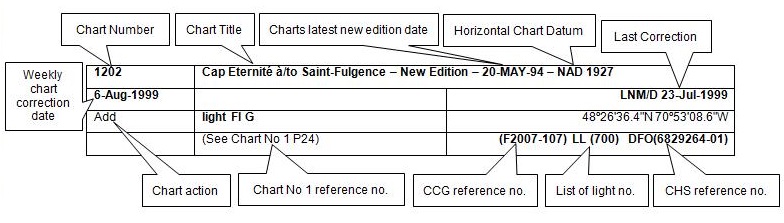
The last correction number is identified with the LNM/D or Last Notice to Mariners Number / Date.
NOTICES TO MARINERS WEBSITE – MONTHLY EDITIONS, CHART CORRECTIONS, AND CHART PATCHES
The Notices to Mariners website allows users to access the monthly publications,
chart corrections, and chart patches.
Users can subscribe for free to the email notification service
to receive notifications when charts of interest are updated, including their patches, as well as when a new monthly edition becomes available online.
ADVISORY NOTICES TO SHIPPING (BROADCAST AND WRITTEN)
The Canadian Coast Guard is implementing a number of changes to the aids to navigation system in Canada.
These changes are advertised as Notices to Shipping (Broadcast and Written) by the Canadian Coast Guard, and are then followed up with Notices to Mariners, then charts are updated by hand correction, reprints or new editions.
Mariners are advised that all relevant Written Notices to Shipping should be kept until superseded by Notices to Mariners or through revised charts issued by the Canadian Hydrographic Service (CHS).
Written Notices to Shipping are available on the Canadian Coast Guard website at: www.ccg-gcc.gc.ca/eng/CCG/NOTSHIP.
The Canadian Hydrographic Service is reviewing the impact of these changes with the Canadian Coast Guard and together are preparing an action plan on the issuing of chart revisions.
For further information, contact your local Regional Notices to Shipping (NOTSHIP) issuing authorities.
Newfoundland
* Port aux Basques MCTS Centre
Canadian Coast Guard
49 Stadium Rd.
P.O. Box 99
Port aux Basques, NL A0M 1C0
Telephone: (709) 695-2168 or 1-800-563-9089
Facsimile: (709) 695-7784
Email: notshippax@dfo-mpo.gc.ca
Website: http://www.ccg-gcc.gc.ca/eng/CCG/Notship#nfld
Central & Arctic
* Prescott MCTS Centre
Canadian Coast Guard
401 King Street West
P.O. Box 1000
Prescott, ON K0E 1T0
“C” Series NOTSHIPs
Telephone: (613) 925-0666
Facsimile: (613) 925-4519
Email: CA.XCA-NotshipDesk@dfo-mpo.gc.ca
Website: http://www.ccg-gcc.gc.ca/eng/CCG/Notship-Home
Maritimes
* Sydney MCTS Centre
Canadian Coast Guard
1190 Westmount Road
Sydney, NS B1R 2J6
Telephone: (902) 564-7751 or 1-800-686-8676
Facsimile: (902) 564-7662
Email: notshipssyd@mar.dfo-mpo.gc.ca
Website: http://www.ccg-gcc.gc.ca/eng/CCG/Notship#maritime
Québec
* Les Escoumins MCTS Centre
Canadian Coast Guard
35, rue Otis
Les Escoumins, QC G0T 1K0
Telephone: (418) 233-2308
Facsimile: (418) 233-3299
Email: opsavis@dfo-mpo.gc.ca
Website: www.marinfo.gc.ca/en/avisecrits/index.asp
* Iqaluit MCTS Centre
Operational from approximately mid-May until late December.
Canadian Coast Guard
P.O. Box 189
Iqaluit, NU X0A 0H0
“A” Series NOTSHIPs
Telephone: (867) 979-5269
Facsimile: (867) 979-4264
Email: IqaNordreg@innav.gc.ca
Website: http://www.ccg-gcc.gc.ca/eng/CCG/Notship-Home
“H” Series NOTSHIPs
Telephone: (867) 979-0310
Facsimile: (867) 979-4264
Email: Iqamck01@innav.gc.ca
Website: http://www.ccg-gcc.gc.ca/eng/CCG/Notship-Home
* Service available in English and French.
Index
NUMERICAL INDEX OF CANADIAN CHARTS AFFECTED
| 1203 | 4002 | 4375 | 4921 |
| 1310 | 4013 | 4430 | 6249 |
| 1313 | 4015 | 4507 | 7083 |
| 1314 | 4022 | 4847 | 7371 |
| 2315 | 4045 | 4851 | 7725 |
SECTION 1 - GENERAL AND SAFETY INFORMATION
CANADIAN HYDROGRAPHIC SERVICE - ANNOUNCEMENT REGARDING CANADIAN HYDROGRAPHIC SERVICE CHART PATCHES
Colour Web Patches are free to the mariner, and given the quality of many printers, should reproduce well. They will be available in real time all around the world.
CHS welcomes your feedback on this service at chsinfo@dfo-mpo.gc.ca.
CANADIAN HYDROGRAPHIC SERVICE - CUMULATIVE CHART CORRECTIONS
The cumulative Notices to Mariners corrections for charts can now be accessed at http://www.notmar.com/corrections-en.php.
CANADIAN HYDROGRAPHIC SERVICE - CURRENT CHART EDITION DATES
CHART EDITIONS
The three terms described below are used to indicate the publication status of Canadian charts.
NEW CHART - "NEWCHT"
The first publication of a Canadian chart embracing an area not previously charted to the scale shown, or embracing an area different from any existing Canadian chart.
NEW EDITION - "NEWEDT"
A new issue of an existing chart containing amendments essential to navigation in addition to those issued in Notices to Mariners and making existing editions obsolete.
REPRINTS
A new issue of the current edition of a chart incorporating no amendments of navigational significance other than those previously promulgated in Notices to Mariners. It may also contain amendments from other sources provided they are not essential to navigation. Previous printings of the current edition remain in force.
The current chart edition dates can be accessed at www.chs-shc.gc.ca/charts-cartes/paper-papier/index-eng.asp
CANADIAN HYDROGRAPHIC SERVICE - PRINT ON DEMAND CHARTS - CARE AND USE
Background
By providing nautical charts to the public, the goal of the Canadian Hydrographic Service (CHS) is to provide services for safe navigation in a fiscally responsible manner. As a result, CHS continues to expand its portfolio of nautical paper charts that are printed using Print On Demand (POD) technology. These charts are easily recognized by their whiter paper and the coloured logo of the Canadian Hydrographic Service. This new technology enables CHS to print charts in a more efficient manner while enhancing chart content through being able to quickly add new and important information. POD technology provides customers with up-to-date charts without the historical hand-drawn corrections or glued-on patches. Additionally, this technology eliminates out-of-stock situations which arise with the traditional printing and warehousing methods. In the event of a national emergency, CHS can respond to the appropriate authorities with best available information very quickly.
Care of Your POD Chart
CHS encourages its customers to handle the POD charts more carefully than the traditional lithographic charts. When plotting information on POD charts, use HB pencils and apply limited pressure. Testing has suggested that an Indian gum eraser is more effective than alternatives when used on the product. This eraser is also suitable for charts printed using lithographic processes.
CANADIAN HYDROGRAPHIC SERVICE, TRANSPORT CANADA - NAVIGATION SAFETY - ECDIS
Mariners are advised that ECDIS may not display some isolated shoal depths when operating in "base or standard display" mode. Route planning and monitoring alarms for these shoal depths may not always be activated. To ensure safe navigation and to confirm that a planned route is clear of such dangers, mariners should visually inspect the planned route and any deviations from it using ECDIS configured to display "all data". The automated voyage planning check function should not be solely relied upon.
TRANSPORT CANADA - RESTRICTED SPEED AREA - ST. CLAIR AND DETROIT RIVER
Since November 14, 2012 the restricted speed area currently in place as per the St. Clair and Detroit River Navigation Safety Regulation between the Detroit River light and Peche Island light is reduced in size by relocating the southern point of the restricted speed area from its current location at the Detroit River light to a new location at Bar Point light D33. (This notice refers to the previous one published in November 2012 with number *1103)
CANADIAN HYDROGRAPHIC SERVICE – END OF CD DISTRIBUTION OF BSB RASTER AND S-57 VECTOR CHARTS
Please be advised that the Canadian Hydrographic Service (CHS) will no longer distribute BSB raster
and S-57 vector files via CD as of December 31st, 2016.
CHS dealers may sell the 2017 edition of raster and vector charts through the CHS Digital Data Portal at
http://register-enregistrer.chs-shc.gc.ca/
Should you have any questions or concerns, please contact chsinfo@dfo-mpo.gc.ca
*1101 CANADIAN HYDROGRAPHIC SERVICE - NAUTICAL CHARTS
| CHARTS | MAIN TITLE | SCALE | PUBLISHED | CAT # | PRICE |
|---|---|---|---|---|---|
| New Edition | |||||
| 7371 | Alexandra Fiord | 1:25000 | 08-JAN-2016 | 4 | 20.00 |
*1102 CANADIAN HYDROGRAPHIC SERVICE - ELECTRONIC NAVIGATIONAL CHARTS
| S-57 ENC NUMBER | CHART TITLE |
|---|---|
| NEW PRODUCTS | |
| CA473447 | Rockhouse Island to/a Centre Island |
| CA473449 | Farther Hope Point to/a Terror Point |
| CA579253 | Port-Daniel-Gascons |
| WITHDRAWN PRODUCT | |
| CA579069 | Port-Daniel |
*1103 CANADIAN HYDROGRAPHIC SERVICE – RASTER DIGITAL CHARTS (BSB V4).
| CHARTS | MAIN TITLE | SCALE | PUBLISHED |
|---|---|---|---|
| New Charts | |||
| RM-3978 | Bonilla Island to/à Edye Passage | 1:80000 | 01-JUL-2016 |
| New Editions | |||
| RM-3938 | Queens Sound to/à Seaforth Channel | 1:40000 | 15-APR-2016 |
| RM-6100 | Lac Saint-Jean | 1:120000 | 15-APR-2016 |
*1104 TRANSPORT CANADA – SHIP SAFETY BULLETIN
This is to notify you that a new Ship Safety Bulletin has recently been posted to the Transport Canada website at:
www.tc.gc.ca/ssb-bsn/.
To go online to view or download this bulletin, please click on the link below:
SSB#10/2016 – Automatic Identification System (AIS)
RDIMS#12268956
Sign yourself up for e-Bulletin to receive an e-mail notice each time a new Ship Safety Bulletin is published on our Website.
Contact us at: marinesafety-securitemaritime@tc.gc.ca or 1-855-859-3123 (Toll Free).
*1105 CANADIAN HYDROGRAPHIC SERVICE – SAILING DIRECTIONS – CEN 309 - TRENT-SEVERN WATERWAY, FIRST EDITION, 2016 IS NOW AVAILABLE AS A PRINT-ON-DEMAND (POD) PRODUCT
The Sailing Directions booklet CEN 309 — Trent-Severn Waterway, First Edition, 2016 cancels and replaces the Small Craft Guide, Trent-Severn Waterway, Seventh Edition, 1989. This new booklet is now available as a Print-on-Demand (POD) product. POD booklets are corrected through Section 4 of Notices to Mariners up to the date of printing. The price of CEN 309, First Edition, is $18.95. Advance orders may be made through any authorized CHS Dealer.
*1106 TADOUSSAC À/TO CAP ÉTERNITÉ – PRIVATE DAYBEACON DISCONTINUED
Reference Chart: 1203
The following private daybeacon has been discontinued:
Anse St-Jean, Breakwater, Northeast end of the floating breakwater (LL 11652.2) (48° 14’ 42.4”N 070° 10’ 50.3”W)
(Q2016-146)
*1107 TADOUSSAC À/TO CAP ÉTERNITÉ – PRIVATE AIDS TO NAVIGATION REPOSITIONED
Reference Chart: 1203
The following private aids to navigation have been repositioned:
The light Anse St-Jean, pontoon, attached to the outer end of the pontoon extending from the breakwater
(LL 11652) (48° 14’ 43.2”N 070° 10’ 48.7”W)
The daybeacon Anse St-Jean, Breakwater, attached to the center of the floating breakwater
(LL 11652.4) (48° 14’ 41.5”N 070° 10’ 54.0”W)
The daybeacon Anse St-Jean, Breakwater, Southwest end of the floating breakwater
(LL 11652.6) (48° 14’ 39.3”N 070° 10’ 54.7”W)
(Q2016-141, 144, 145)
*1108 TADOUSSAC À/TO CAP ÉTERNITÉ – PRIVATE LIGHTS ESTABLISHED
Reference Chart: 1203
The following private lights have been established:
Anse-Saint-Jean, Breakwater, Northeast end of the floating breakwater (LL 11652.3) (48° 14’ 42.8”N 070° 10’ 50.2”W)
Anse-Saint-Jean, Breakwater, center of the breakwater (LL 11652.5) (48° 14’ 41.9”N 070° 10’ 52.8”W)
(Q2016-142, 143)
*1109 PORT DE MONTRÉAL – PRIVATE UNLIT BUOYS ESTABLISHED
Reference Chart: 1310
The following private unlit buoys have been established:
Parc des Îles de Boucherville, La Grande Rivière PRIV (LL 12806) (45° 36’ 18.7”N 073° 27’ 45.7”W)
Parc des Îles de Boucherville, La Grande Rivière PRIV (LL 12807) (45° 36’ 14.1”N 073° 27’ 54.4”W)
Parc des Îles de Boucherville, La Grande Rivière PRIV (LL 12808) (45° 36’ 06.7”N 073° 28’ 09.7”W)
Parc des Îles de Boucherville, La Grande Rivière PRIV (LL 12809) (45° 36’ 02.8”N 073° 28’ 22.2”W)
Parc des Îles de Boucherville, La Grande Rivière PRIV (LL 12810) (45° 36’ 00.0”N 073° 28’ 33.2”W)
Parc des Îles de Boucherville, La Grande Rivière PRIV (LL 12811) (45° 36’ 00.2”N 073° 28’ 18.2”W)
Parc des Îles de Boucherville, La Grande Rivière PRIV (LL 12812) (45° 35’ 52.7”N 073° 28’ 26.1”W)
Parc des Îles de Boucherville, La Grande Rivière PRIV (LL 12813) (45° 35’ 48.7”N 073° 28’ 36.4”W)
Parc des Îles de Boucherville, La Grande Rivière PRIV (LL 12814) (45° 35’ 58.8”N 073° 28’ 32.6”W)
Parc des Îles de Boucherville, La Grande Rivière PRIV (LL 12815) (45° 36’ 02.2”N 073° 28’ 22.1”W)
Parc des Îles de Boucherville, La Grande Rivière PRIV (LL 12816) (45° 35’ 48.1”N 073° 28’ 35.9”W)
Parc des Îles de Boucherville, La Grande Rivière PRIV (LL 12817) (45° 35’ 52.2”N 073° 28’ 25.3”W)
Parc des Îles de Boucherville, La Grande Rivière PRIV (LL 12818) (45° 36’ 06.0”N 073° 28’ 09.1”W)
Parc des Îles de Boucherville, La Grande Rivière PRIV (LL 12819) (45° 36’ 13.3”N 073° 27’ 53.8”W)
Parc des Îles de Boucherville, La Grande Rivière PRIV (LL 12820) (45° 36’ 17.8”N 073° 27’ 45.3”W)
(Q2016-098, 099, 100, 101, 102, 103, 104, 105, 106, 107, 108, 109, 110, 111, 112)
*1110 PLANS, BAIE DES CHALEURS/CHALEUR BAY (CÔTE NORD/NORTH SHORE) – PRIVATE LIGHTS ESTABLISHED
Reference Chart: 4921
The following private lights have been established:
Carleton, East Breakwater (LL 12226) (48° 06’ 00.6”N 066° 07’ 47.0”W)
Carleton, Floating Breakwater, South of West Breakwater (LL 12227) (48° 05’ 59.7”N 066° 07’ 50.2”W)
Carleton, Floating Breakwater, South of West Breakwater (LL 12228) (48° 06’ 00.6”N 066° 07’ 50.8”W)
Carleton, Floating Breakwater, South of West Breakwater (LL 12229) (48° 05’ 59.0”N 066° 07’ 49.8”W)
(Q2016-149, 150, 151, 152)
*1111(P) HARBOURS ON THE EAST SHORE OF LAKE SUPERIOR/PORTS SUR LA RIVE EST DU LAC SUPÉRIEUR – FOG HORN TO BE DISCONTINUED
Reference Chart: 2315
The Canadian Coast Guard proposes to permanently discontinue the fog horn of the following aid to navigation:
Michipicoten Harbour (LL 1093) (47º 56’ 32.9’’N 084º 54’ 26.7’’W). The light and structure will remain.
Comments on this action are solicited from mariners and other interested parties.
Comments should be directed to the following within three months from the date of this notice:
Supervisor, Gary Greer
Aids to Navigation and Waterways
28 Waubeek St.
Parry Sound, ON, P2A 1B9
Email: gary.greer@dfo-mpo.gc.ca
Any objections must state the facts on which they are based and should include supporting information on safety, commerce and public benefit.
(D2016-013)
*1112(P) CONCEPTION BAY – FOG SIGNAL TO BE DISCONTINUED
Reference Chart: 4847
The Canadian Coast Guard proposes to permanently discontinue the fog signal of the following aid to navigation:
Cape St. Francis (LL 499) (47° 48' 31.4"N 052° 47' 11.7"W).
The light and structure will remain.
Comments on this action are solicited from mariners and other interested parties.
Comments should be directed to the following within three months from the date of this notice:
Superintendent, Renee Pope
Aids to Navigation and Waterways
Canadian Coast Guard
P.O. Box 5667
St. John’s, NL, A1C 5X1
Telephone: (709) 772-2800
Email: renee.pope@dfo-mpo.gc.ca
Any objections must state the facts on which they are based and should include supporting information on safety, commerce and public benefit.
(N2016-074P)
*1113(P) TRINITY BAY: SOUTHERN PORTION / PARTIE SUD – LIGHT TO BE DISCONTINUED
Reference Chart: 4851
The Canadian Coast Guard proposes to permanently discontinue the following aid to navigation:
Greens Harbour Floating Breakwater (LL 467.01) (47° 38' 36.0"N 053° 30' 22.0"W)
Comments on this action are solicited from mariners and other interested parties.
Comments should be directed to the following within three months from the date of this notice:
Superintendent, Renee Pope
Aids to Navigation and Waterways
Canadian Coast Guard
P.O. Box 5667
St. John’s, NL, A1C 5X1
Telephone: (709) 772-2800
Email: renee.pope@dfo-mpo.gc.ca
Any objections must state the facts on which they are based and should include supporting information on safety, commerce and public benefit.
(N2016-072P)
*1114(P) GULL HARBOUR TO/À RIVERTON – RANGE LIGHTS TO BE REPLACED WITH SECTOR LIGHT
Reference Chart: 6249
The Canadian Coast Guard proposes to establish the following aid to navigation:
Icelandic River Sector Light (LL 1576.5) (approximate position 51º 01’ 53.1’’N 096º 58’ 48.1’’W).
The sector light will exhibit the following characteristics:
Q1s R (Red): 103.5° to 104.0°
Fixed W (White): 104.0° to 104.5°
Q1s G (Green): 104.5° to 105.0°
All bearings are from seaward.
The following aids to navigation will be discontinued in order to establish the aid to navigation mentioned above:
Icelandic River range front (LL 1576) (51º 01’ 45.8’’N 096º 57’ 43.6’’W NAD Unknown)
Icelandic River range rear (LL 1577) (285°30’ 1320m from front.)
Comments on this action are solicited from mariners and other interested parties.
Comments should be directed to the following within three months from the date of this notice:
Superintendent, Kevin Carrigan
Aids to Navigation and Waterways, Western Region
Canadian Coast Guard
25 Huron Street
Victoria, BC, V8V 4V9
Telephone: 250-480-2602
Fax: 250-480-2702
Email: kevin.carrigan@dfo-mpo.gc.ca
Any objections must state the facts on which they are based and should include supporting information on safety, commerce and public benefit.
(A2016-022)
*1115 GUYON ISLAND TO / À FLINT ISLAND – FOG SIGNAL PERMANENTLY DISCONTINUED
Reference: Notice 113(P)/16 is cancelled (Chart 4375).
(G2016-124)
SECTION 2 - CHART CORRECTIONS
1313 - Batiscan au/to Lac Saint-Pierre - New Edition - 07-JUN-2013 - NAD 1983
| 18-NOV-2016 | LNM/D. 04-NOV-2016 | |||
| Delete | limits of arc of visibility against sector light G. |
joining 46°25′48.8″N 072°21′31.5″W 46°26′22.6″N 072°20′41.5″W and 46°25′41.0″N 072°21′17.0″W |
||
| (See Chart No. 1, P40.1) | ||||
| This notice affects Electronic Chart: CA479014 | ||||
| (Q2016154) LL(2062) DFO(6409575-01) | ||||
| 04-NOV-2016 | LNM/D. 18-DEC-2015 | |||
| Affix | patch | 46°23′55.0″N 072°13′28.0″W | ||
|
Download patch - http://www.chs-shc.gc.ca/patches/PA1313-20160909.pdf |
||||
| DFO(6409557-01) | ||||
| Amend |
vertical clearance of 4 metres 3 decimetres, to read 4 metres 2 decimetres
(See Chart No. 1, D22) |
46°27′08.3″N 072°17′02.2″W | ||
| This notice affects Electronic Chart: CA479014 | ||||
| DFO(6409559-01) | ||||
| Amend |
vertical clearance of 8 metres 7 decimetres, to read 4 metres 9 decimetres
(See Chart No. 1, D22) |
46°27′00.5″N 072°16′49.2″W | ||
|
This notice affects Electronic Chart: CA479014 |
||||
| DFO(6409559-02) | ||||
| Amend |
vertical clearance of 3 metres 2 decimetres, to read 3 metres 1 decimetre
(See Chart No. 1, D22) |
46°21′16.5″N 072°26′19.9″W | ||
| This notice affects Electronic Chart: CA479014 | ||||
| DFO(6409559-05) | ||||
1313 - Port de Trois-Rivières - New Edition - 07-JUN-2013 - NAD 1983
| 04-NOV-2016 | LNM/D. 18-DEC-2015 | ||
| Amend |
vertical clearance of 3 metres 7 decimetres, to read 3 metres 6 decimetres
(See Chart No. 1, D22) |
46°21′24.1″N 072°31′36.2″W | |
| This notice affects Electronic Chart: CA579015 | |||
| DFO(6409559-03) | |||
| Amend |
vertical clearance of 3 metres 8 decimetres, to read 3 metres 7 decimetres
(See Chart No. 1, D22) |
46°21′35.5″N 072°32′08.9″W | |
| This notice affects Electronic Chart: CA579015 | |||
| DFO(6409559-04) | |||
| Amend |
vertical clearance of 3 metres 5 decimetres, to read 3 metres 4 decimetres
(See Chart No. 1, D22) |
46°21′46.6″N 072°31′54.4″W | |
| This notice affects Electronic Chart: CA579015 | |||
| DFO(6409559-06) | |||
| Amend |
vertical clearance of 6 metres 5 decimetres, to read 5 metres 5 decimetres
(See Chart No. 1, D22) |
46°21′14.0″N 072°31′29.2″W | |
| This notice affects Electronic Chart: CA579015 | |||
| DFO(6409559-07) | |||
| Amend |
vertical clearance of 7 metres 2 decimetres, to read 7 metres 0 decimetres
(See Chart No. 1, D22) |
46°21′26.5″N 072°31′26.6″W | |
| This notice affects Electronic Chart: CA579015 | |||
| DFO(6409559-08) | |||
| Amend |
vertical clearance of 3 metres 0 decimetres, to read 2 metres 8 decimetres
(See Chart No. 1, D22) |
46°21′42.2″N 072°31′24.4″W | |
| This notice affects Electronic Chart: CA579015 | |||
| DFO(6409559-09) | |||
1314 - Donnacona à/to Batiscan - New Edition - 21-JUN-2013 - NAD 1983
| 18-NOV-2016 | LNM/D. 17-JUN-2016 | ||
| Amend |
Iso Y 2s10m7M to read F G 10m7M against light.
Delete limits of obscured arcs (obscd) (See Chart No. 1, P16, P43) |
46°40′12.4″N 071°50′48.4″W | |
| This notice affects Electronic Chart: CA479017 | |||
| (Q2016158) LL(1993.7) DFO(6409579-01) | |||
4002 - Golfe du Saint-Laurent / Gulf of St. Lawrence - New Edition - 30-OCT-2015 - NAD 1983
| 25-NOV-2016 | LNM/D. 26-AUG-2016 | |||
| Delete |
legend Fog Sig against light
(See Chart No. 1, R1, R20) |
46°02′04.0″N 059°40′33.0″W | ||
| This notice affects Electronic Chart: CA179245, CA276271, CA376303 | ||||
| DFO(6307705-02) | ||||
4013 - Halifax to / à Sydney - New Edition - 06-SEP-2002 - NAD 1983
| 25-NOV-2016 | LNM/D. 26-AUG-2016 | |||
| Amend |
Fl 15s64ft13M to read Fl 3s64ft13M against light
(See Chart No. 1, P16) |
46°02′04.3″N 059°40′48.0″W | ||
| This notice affects Electronic Chart: CA276271, CA376303 | ||||
| (G2016124) LL(767) DFO(6307705-01) | ||||
| Delete |
legend Fog Sig against light
(See Chart No. 1, R1, R20) |
46°02′04.3″N 059°40′48.0″W | ||
| This notice affects Electronic Chart: CA179245, CA276271, CA376303 | ||||
| DFO(6307705-02) | ||||
4015 - Sydney to / à Saint-Pierre - New Edition - 28-MAR-2003 - NAD 1983
| 25-NOV-2016 | LNM/D. 02-SEP-2016 | |||
| Amend |
Fl 15s64ft13M to read Fl 3s64ft13M against light
(See Chart No. 1, P16) |
46°02′04.3″N 059°40′42.0″W | ||
| This notice affects Electronic Chart: CA276271, CA376303 | ||||
| (G2016124) LL(767) DFO(6307705-01) | ||||
| Delete |
legend Fog Sig against light
(See Chart No. 1, R1, R20) |
46°02′04.3″N 059°40′42.0″W | ||
| This notice affects Electronic Chart: CA179245, CA276271, CA376303 | ||||
| DFO(6307705-02) | ||||
4022 - Cabot Strait and approaches / Détroit de Cabot et les approches - New Edition - 17-JAN-2003 - NAD 1983
| 25-NOV-2016 | LNM/D. 27-MAY-2016 | |||
| Amend |
Fl 15s64ft13M to read Fl 3s64ft13M against light
(See Chart No. 1, P16) |
46°02′04.3″N 059°40′45.0″W | ||
| This notice affects Electronic Chart: CA276271, CA376303 | ||||
| (G2016124) LL(767) DFO(6307705-01) | ||||
| Delete |
legend Fog Sig against light
(See Chart No. 1, R1, R20) |
46°02′04.3″N 059°40′45.0″W | ||
| This notice affects Electronic Chart: CA179245, CA276271, CA376303 | ||||
| DFO(6307705-02) | ||||
4045 - Sable Island Bank / Banc de I'Île de Sable to / au St. Pierre Bank / Banc de Saint-Pierre - New Edition - 10-OCT-2003 - NAD 1983
| 25-NOV-2016 | LNM/D. 26-AUG-2016 | |||
| Amend |
Fl 15s19m13M to read Fl 3s19m13M against light
(See Chart No. 1, P16) |
46°02′04.3″N 059°40′45.0″W | ||
| This notice affects Electronic Chart: CA276271, CA376303 | ||||
| (G2016124) LL(767) DFO(6307705-01) | ||||
| Delete |
legend Fog Sig against light
(See Chart No. 1, R1, R20) |
46°02′04.3″N 059°40′45.0″W | ||
| This notice affects Electronic Chart: CA179245, CA276271, CA376303 | ||||
| DFO(6307705-02) | ||||
4375 - Guyon Island to / à Flint Island - New Edition - 11-OCT-2002 - NAD 1983
| 25-NOV-2016 | LNM/D. 26-AUG-2016 | |||
| Amend |
Fl 15s64ft13M to read Fl 3s64ft13M against light
(See Chart No. 1, P16) |
46°02′04.3″N 059°40′33.7″W | ||
| This notice affects Electronic Chart: CA276271, CA376303 | ||||
| (G2016124) LL(767) DFO(6307705-01) | ||||
| Delete |
legend Fog Sig (3) 60 s against light
(See Chart No. 1, R1, R20) |
46°02′04.3″N 059°40′33.7″W | ||
| This notice affects Electronic Chart: CA179245, CA276271, CA376303 | ||||
| DFO(6307705-02) | ||||
4430 - Pointe de l'Est - New Edition - 22-MAY-2015 - NAD 1983
| 18-NOV-2016 | LNM/D. 15-JAN-2016 | |||
| Add |
depth of 3 metres 2 decimetres
(See Chart No. 1, I10) |
49°05′55.7″N 061°41′45.0″W | ||
| This notice affects Electronic Chart: CA379151 | ||||
| DFO(6409564-01) | ||||
| Add |
depth of 1 metre 9 decimetres
(See Chart No. 1, I10) |
49°05′54.9″N 061°41′55.7″W | ||
| This notice affects Electronic Chart: CA379151 | ||||
| DFO(6409564-02) | ||||
4507 - St Lunaire Bay - New Edition - 05-DEC-2003 - NAD 1983
| 25-NOV-2016 | LNM/D. 07-OCT-2016 | ||
| Delete |
depth of 2 1/4 fathoms
(See Chart No. 1, I10) |
51°30′00.7″N 055°28′30.7″W | |
| DFO(6307691-01) | |||
| Add | extension to pier |
joining 51°30′00.7″N 055°28′29.8″W 51°30′01.7″N 055°28′31.5″W 51°30′01.9″N 055°28′31.2″W and 51°30′00.9″N 055°28′29.5″W |
|
| (See Chart No. 1, F14) | |||
| DFO(6307691-02) | |||
| Reposition | light Fl R |
from 51°29′59.4″N 055°28′27.0″W to 51°30′01.6″N 055°28′31.4″W |
|
| (See Chart No. 1, P1) | |||
| (N2016060) LL(239.27) DFO(6307691-03) | |||
7083 - Cambridge Bay to/à Shepherd Bay - New Edition - 15-JUN-1984 - Inconnu
| 18-NOV-2016 | LNM/D. 06-NOV-2015 | |||
| Add |
obstruction depth unknown, Rep (2016)
(See Chart No. 1, K40, I3.2) |
68°36′51.6″N 100°13′21.6″W | ||
| DFO(6604244-01) | ||||
7725 - Requisite Channel and Approaches - New Edition - 22-JUN-1984 - Inconnu
| 18-NOV-2016 | LNM/D. 23-MAY-2014 | |||
| Add |
obstruction depth unknown, Rep (2016)
(See Chart No. 1, K40, I3.2) |
68°36′51.6″N 100°13′21.6″W | ||
| DFO(6604244-01) | ||||
SECTION 3 - RADIO AIDS TO MARINE NAVIGATION CORRECTIONS
*1125 RADIO AIDS TO MARINE NAVIGATION 2016, (ATLANTIC, ST. LAWRENCE, GREAT LAKES, LAKE WINNIPEG AND ARCTIC)
PART 3 - Page 32
AMEND:
Table 3-16 - Calling-In-Points for Port aux Basques
| Number | Sector | Name | General Description and Conditions | Geographic Description |
|---|---|---|---|---|
| 1 | 1 | Cape Ray | Off Cape Ray | From Cape Ray, at 47°37’04”N 059°18’05”W, along the boundary between Fishing zones 1 and 4, to position 47°29’56”N 059°32’20.4”W. |
| 2 | 1 | Southern limit | Crossing the southern zone limit | An arc, centred on position 47°43’07”N 059°05’59.7”W, and connecting the following points: 47°29’56”N 059°32’20.4”W, 47°28’18.1”N 059°30’21.7”W, 47°26’48.2”N 059°28’10”W, 47°25’27.1”N 059°25’46.3”W, 47°24’15.6”N 059°23’12.1”W, 47°23’14.4”N 059°20’28.6”W, 47°22’24”N 059°17’37.4”W; - thence, along the Canadian Territorial Sea boundary to position 47°23’37.3”N 058°42’01.9”W. |
| 3 | 1 | Rose Blanche | Off Rose Blanche Point | A line bearing 180° True from Rose Blanche Point, at position 47°36’06.5”N 058°41’40.4”W, to the limit of Canadian waters at 47°23’37.3”N 058°42’01.9”W.. |
| 4 | 1 | Ferry Track | Crossing the Port aux Basques, NL, North Sydney, NS, recommended ferry track | A line from position 47°33’00”N 059°07’27.4”W, to the southern limit of the zone at position 47°22’09”N 059°16’26.6”W. |
| 5 | 1 | 5 NM off Channel Head | 5 NM off Channel Head | An arc centered on 47°33’57”N 059°07’24.5”W, Radius 5 NM, and extending from shore to shore, connecting the following points: 47°35’09.7”N 059°00’14.4”W and 47°28’57”N 059°07’24.5”W and 47°36’02.8”N 059°14’07”W. |
| 6 | 1 | 2 NM off Channel Head | 2 NM off Channel Head | An arc centered on 47°33’57”N 059°07’24.5”W, Radius 5 NM, and extending from shore to shore, connecting the following points: 47°34’27”N 059°04’32.8”W, 47°31’57”N 059°07’24.5”W and 47°34’12.2”N 059°10’20.4”W. |
TO READ:
Table 3-16 - Calling-In-Points for Port aux Basques
| Number | Sector | Name | General Description and Conditions | Geographic Description |
|---|---|---|---|---|
| 1 | 1 | Cape Ray | Off Cape Ray | From Cape Ray, at 47°37’04”N 059°18’05”W, along the boundary between Fishing zones 1 and 4, to position 47°29’56”N 059°32’20.4”W. |
| 2 | 1 | Southern limit | Crossing the southern zone limit | An arc, centred on position 47°43’07”N 059°05’59.7”W, and connecting the following points: 47°29’56”N 059°32’20.4”W, 47°28’18.1”N 059°30’21.7”W, 47°26’48.2”N 059°28’10”W, 47°25’27.1”N 059°25’46.3”W, 47°24’15.6”N 059°23’12.1”W, 47°23’14.4”N 059°20’28.6”W, 47°22’24”N 059°17’37.4”W; - thence, along the Canadian Territorial Sea boundary to position 47°23’37.3”N 058°42’01.9”W. |
| 3 | 1 | Rose Blanche | Off Rose Blanche Point | A line bearing 180° True from Rose Blanche Point, at position 47°36’06.5”N 058°41’40.4”W, to the limit of Canadian waters at 47°23’37.3”N 058°42’01.9”W.. |
| 4 | 1 | Ferry Track | Crossing the Port aux Basques, NL, North Sydney, NS, recommended ferry track | A line from position 47°33’00”N 059°07’27.4”W, to the southern limit of the zone at position 47°22’09”N 059°16’26.6”W. |
| 5 | 1 | 5 NM off Channel Head | 5 NM off Channel Head | An arc centered on 47°33’57”N 059°07’24.5”W, Radius 5 NM, and extending from shore to shore, connecting the following points: 47°35’09.7”N 059°00’14.4”W and 47°28’57”N 059°07’24.5”W and 47°36’02.8”N 059°14’07”W. |
| 6 | 1 | 2 NM off Channel Head | 2 NM off Channel Head | An arc centered on 47°33’57”N 059°07’24.5”W, Radius 2 NM, and extending from shore to shore, connecting the following points: 47°34’27”N 059°04’32.8”W, 47°31’57”N 059°07’24.5”W and 47°34’12.2”N 059°10’20.4”W. |
SECTION 4 - SAILING DIRECTIONS AND SMALL CRAFT GUIDE CORRECTIONS
ATL 104 — Cape North to Cape Canso (including Bras d’Or Lake), Second Edition, 2010 —
Chapter 1 — Paragraph 92, after “starboard hand light”
Delete: and bell
(A2016-004.10)
Chapter 1 — Paragraph 128, after “on the island.”
Delete: “A remotely operated fog signal … this procedure can be repeated.”
(A2016-004.11)
ATL 105 — Cape Canso to Cape Sable (including Sable Island), Second Edition, 2014 —
Chapter 1 — Paragraph 86
Delete: “A fog signal … horn points 155°.”
(A2016-005.7)
Chapter 4 — After paragraph 63
Insert: 63.1 A submarine cable runs from the NW end of
The Peninsula west to Little Fish Island, and then SW to Big Gooseberry Island. Caution is advised.
(A2016-005.8)
Chapter 4 — Adjacent to paragraph 63.1, add a caution pictograph.
(A2016-005.9)
Chapter 5 — Paragraph 10
Delete: “A fog signal … adjacent to the light.”
(A2016-005.10)
ATL 108 — Gulf of St. Lawrence (Southwest Portion), First Edition, 2006 —
Chapter 4 — Paragraph 202, last line
Add: There are wharves, floating docks, a launching ramp and water and power outlets. (See the Gascons diagram.)
(Q2016-065.1)
Chapter 4 — Adjacent to paragraph 202, add a wharf pictograph.
(Q2016-065.2)
Chapter 4 — Delete paragraph 203 and adjacent pictograph.
(Q2016-065.3)
Chapter 4 — In the vicinity of paragraph 202
Replace the GASCONS diagram with the new one provided in Section 4 of this Monthly Edition.
https://www.notmar.gc.ca/publications/monthly-mensuel/images/ed112016-part4-atl108-gascons.pdf
(Q2016-065.4)
Chapter 4 — Before paragraph 239
Delete: Chart 4921
(Q2016-067.1)
Chapter 4 — Paragraph 239
Delete: “There is a depth … along the last 120 m.”
(Q2016-067.2)
Chapter 4 — After paragraph 240
Insert: 240.1 Due to continuous silting, mariners should expect to find less water at some places.
For the latest information on depths, it is recommended to check with the appropriate local authority. A crib,
with 1.6 m over it, lies about 20 m NE of the breakwater.
(Q2016-067.3)
Chapter 4 — Adjacent to paragraph 240.1, add a caution pictograph.
(Q2016-067.4)
Chapter 4 — In the vicinity of paragraph 240
Insert the new diagram of NEW RICHMOND that is provided in Section 4 of this Monthly Edition.
https://www.notmar.gc.ca/publications/monthly-mensuel/images/ed112016-part4-atl108-newrichmond.pdf
(Q2016-067.5)
ATL 110 — St. Lawrence River — Cap Whittle/Cap Gaspé to Les Escoumins and Anticosti Island, Third Edition, 2011 —
Chapter 2 — In the vicinity of paragraph 32
Replace the L’ANSE-AU-GRIFFON diagram with the new one provided in Section 4 of this Monthly Edition.
https://www.notmar.gc.ca/publications/monthly-mensuel/images/ed112016-part4-atl110-lanseaugriffon.pdf
(Q2016-066.1)
ATL 111 — St. Lawrence River — Île Verte to Québec and Fjord du Saguenay, Third Edition, 2007 —
Chapter 4 — Paragraph 52, after “are situated nearby.”
Insert: A floating breakwater, marked by a private light and two daybeacons, protects the floating docks.
(Q2016-062.1)
ATL 112 — St. Lawrence River — Cap-Rouge to Montréal and Rivière Richelieu, Third Edition, 2009 —
Chapter 1 — Paragraph 117, after “The light is visible”
Delete: from upstream only, over an arc of 15° centered
(Q2016-064.1)
Chapter 1 — Paragraph 117, after “A second light”
Insert: (2062.1)
(Q2016-064.2)
SECTION 5 - LIST OF LIGHTS, BUOYS AND FOG SIGNALS CORRECTIONS
NEWFOUNDLAND
| No. | Name | Position ----- Latitude N. Longitude W. |
Light Characteristics |
Focal Height in m. above water |
Nominal Range |
Description ----- Height in meters above ground |
Remarks ----- Fog Signals |
|||
|---|---|---|---|---|---|---|---|---|---|---|
| 74.61 | Lord’s Cove Inner light buoy PC4 | 46 52 38.4 055 40 03.0 |
Fl | R | 4s | ..... | ..... | Red spar, marked "PC4". |
Seasonal. Chart:4625 Edn 11/16 (N16-050) |
|
| 239.27 H0737 |
St. Lunaire, Wharf Light | 51 30 01.6 055 28 31.4 |
Fl | R | 4s | 3.5 | 2 | Mast. | Seasonal.
Chart:4507 Edn 11/16 (N16-060) |
|
| 507.5 | Petty Harbour Shoal light buoy MP2 | 47 27 53.3 052 42 04.0 |
Fl | R | 4s | ..... | ..... | Red spar, marked "MP2". | Seasonal. Chart: 4845 Edn 11/16 (N16-057) |
|
ATLANTIC
| No. | Name | Position ----- Latitude N. Longitude W. |
Light Characteristics |
Focal Height in m. above water |
Nominal Range |
Description ----- Height in meters above ground |
Remarks ----- Fog Signals |
|||
|---|---|---|---|---|---|---|---|---|---|---|
| 767 H0742 |
Scatarie | NE. point of Scatarie Island. 46 02 04.3 059 40 33.7 |
Fl | W | 3s | 19.5 | 13 | Square tower, 3 rectangular daymarks, horizontal red and white band. | Flash 1s; eclipse 2s. Year round. Visible from all points of marine approach. Chart: 4375 Edn 11/16 (G16-124) |
|
| 1410.5 | Mal-Bay light buoy AM2 | Delete from list.. Chart: 4921 Edn 11/16 (Q16-140) |
||||||||
| 1558.7 H1901 |
Cap Airey | S. end of Île du Cap. 50 28 13.7 059 27 26.2 |
Fl | G | 6s | 17.6 | 6 | Square skeleton tower. 6.6 |
Flash 1s; eclipse 5s. Year round. Position in NAD83. Chart : 4468 Edn 11/16 |
|
| 1559 H1900 |
Falaise de l'Entrée | S. side of Île de l’Entrée, N. side of channel, Havre de Harrington entrance. 50 29 19.5 059 27 40.7 |
Fl | W | 6s | 41.7 | 8 | Square skeleton tower. 9.6 |
Flash 1s; eclipse 5s. Year round. Position in NAD83. Chart:4468 Edn 11/16 |
|
| 1559.2 H1900.4 |
Île de l'Entrée | NW. point of island. 50 29 33.6 059 28 09.2 |
Fl | G | 6s | 7.8 | 6 | Square skeleton tower. 6.6 |
Flash 1s; eclipse 5s. Year round. Position in NAD83. Chart:4468 Edn 11/16 |
|
| 1559.5 |
Harrington Harbuor | 50 29 46.6 059 28 32.1 |
Fl | Y | 6s | 8.9 | 8 | Square mast. 8.0 |
Flash 1s; eclipse 5s. Year round. Position in NAD83. Chart:4468 Edn 11/16 |
|
| 1560 H1902 1561 H1902.1 |
Harrington Harbour range |
On N. side of small island SW. of Île Hospital. 50 29 34.3 059 29 00.8 288°44' 188.9m from front. |
F F |
R R |
..... ..... |
10.2 15.4 |
13 13 |
Square skeleton tower, orange daymark, black vertical stripe. 6.3 Square skeleton tower, orange daymark, black vertical stripe. 4.8 |
Visible in line of range. Year round. Position in NAD83. Visible in line of range. Year round. Chart:4468 Edn 11/16 |
|
| 1561.5 H1903 |
Rivière Nétagamiou | 50 28 21.2 059 36 20.0 |
Fl | R | 6s | 8.8 | 5 | Square mast. 6.5 |
Flash 1s; eclipse 5s. Seasonal. Position in NAD83. Chart:4468 Edn 11/16 |
|
| 1561.7 | Rivière Nétagamiou Entrance light buoy CS2 | 50 27 08.9 059 36 39.8 |
Fl | R | 4s | ..... | ..... | Red, marked "CS2". | Seasonal. Position in NAD83. Chart:4468 Edn 11/16 |
|
| 1561.71 | Fairway light buoy CHE | At river entrance. 50 27 13.3 059 37 23.4 |
Mo(A) | W | 6s | ..... | ..... | Red and white vertical stripes, marked "CHE". | Seasonal. Position in NAD83. Chart:4468 Edn 11/16 |
|
| 1561.72 | Light buoy CS3 | At river entrance. 50 27 26.7 059 37 17.7 |
Fl | G | 4s | ..... | ..... | Green, marked "CS3". | Seasonal. Position in NAD83. Chart:4468 Edn 11/16 |
|
| 1562 H1904 |
Île Sainte-Marie | On the summit of the W. Île Sainte-Marie. 50 18 15.2 059 39 20.4 |
Fl | W | 2.5s | 44.4 | 12 | Square skeleton tower. 16.4 |
Flash 0.1s; eclipse 2.4s. Seasonal. Position in NAD83. Chart:4468 Edn 11/16 |
|
| 1666.07 | Sept Îles, Terminal des croisières |
East end of Duc d'Albe, section 12. 50 11 50.6 066 22 48.7 |
Iso | W | 2s | ..... | ..... | Mast. | Privately maintained. Year round. Chart:1220 Edn 11/16 (Q16-156) |
|
| 1672.7 | Sept-Îles, Pointe Noire | Section 35, West end. 50 10 05.9 066 28 15.7 |
Iso | R | 1s | ..... | 6 | Cylindrical mast. | Privately maintained. Year round. Chart:1220 Edn 11/16 (Q16-147) |
|
| 1672.9 | Sept-Îles, Pointe Noire | Section 35, East end. 50 10 01.5 066 27 56.4 |
Iso | G | 1s | ..... | 6 | Cylindrical mast. | Privately maintained. Year round. Chart:1220 Edn 11/16 (Q16-148) |
|
| 1840 H2186 |
Cap à l’Aigle | East end of pier. 47 39 43.0 070 05 46.7 |
Iso | R | 2s | 6.1 | 6 | Mast. | Privately maintained. Year round. Chart:1234 Edn 11/16 (Q14-092) |
|
| 1993.7 H2343 |
Pointe Platon | On point. 46 40 12.4 071 50 48.4 |
F | G | ..... | 9.6 | 7 | Square skeleton tower, orange rectangular slatwork daymarks. 8.0 |
Visible 360°. Emergency mode. Radar reflector. Year round. Chart:1314 Edn 11/16 (Q16-158) |
|
| 2062 H2382 2062.1 |
Champlain Champlain Secondary light |
West of village. 46 26 22.6 072 20 41.5 |
F Fl |
G R |
..... 5s |
18.1 14.4 |
16 6 |
White skeleton tower, orange daymark. 14.6 |
Visible on a bearing of 038°. Year round. Flash 1s; eclipse 4s. Visible 360°. Year round. Chart:1313 Edn 11/16 (Q16-154) |
|
| 2137.2 H2405 2137.21 2137.3 H2405.1 |
Yamachiche range Racon - - (M) X & S Bands |
46 12 18.7 072 49 49.1 236°01’ 761.8m from front. |
F Fl F |
G G G |
..... 6s ..... |
12.4 12.4 25.5 |
14 5 14 |
Square skeleton tower, orange daymark, black vertical stripe. 4.9 Square skeleton tower. 4.9 White tower, orange daymark, black vertical stripe. 17.3 |
Emergency mode. Visible in line of range. Operates at night only. Year round. Flash 1s; eclipse 5s. Visible 360°. Operates at night only. Emergency mode. Visible in line of range. Operates at night only. Year round. Chart:1313 Edn 11/16 (Q16-153) |
|
| 2258.93 |
Light buoy EA22 | 45 07 31.3 073 16 04.9 |
Fl | R | 4s | ..... | ..... | Red spar, marked "EA22". | Saisonnier (en place à longueur d'année). Chart:1351 Edn 11/16 (Q16-155) |
|
CANADIAN COAST GUARD - MARINE INFORMATION REPORT AND SUGGESTION SHEET
Name of Ship or Sender:..................................................................... Date:....................................
Address of Sender:..........................................................................................................................
Street # Street Name
Town / City:.............................. Prov / State:....................... Postal Code / Zip Code: ........................
Tel / Fax / E-mail address of sender (if appropriate):............................................................................
Observation Date:............................................. Time (UTC): ...........................................................
Geographical Position:......................................................................................................................
Coordinate Position: Lat: ............................................... Long:.........................................................
Position Method: DGPS GPS with WAAS GPS Radar Other
Horizontal Datum Used: WGS 84 NAD 27 Other
Estimated Position Accuracy:............................................................................................................
Chart #:............................................................ Datum: NAD 27 NAD 83
Chart Edition:.................................................... Last Correction applied:............................................
Publications affected: (Quote edition and page number):.....................................................................
*Full details (Attach additional sheets as necessary):...........................................................................
Mariners are requested to notify the responsible authorities when new or suspected dangers to navigation are discovered, changes are observed in aids to navigation, or corrections to publications are seen to be necessary.
In the case of new or suspected dangers to navigation, it is important that all details be given in order to aid with future investigations. Items of interest include heights, depths, physical description, type of bottom and equipment method used to position the item. It is helpful to mark details on the chart, which will be promptly replaced by the Canadian Hydrographic Service.
Reports should be made to the nearest Marine Communications and Traffic Services Centre (MCTS) and should be confirmed in writing to:
Leader, Notices to Mariners
Canadian Coast Guard
Department of Fisheries and Oceans
Montréal, QC H2Y 2E7
In the case of information concerning aids to navigation or the List of Lights, Buoys and Fog Signals book.
OR
Director General, Canadian Hydrographic Service & Oceanographic Services
Department of Fisheries and Oceans
Ottawa, ON K1A 0E6
In the case of new or suspected dangers to navigation or where corrections to "Sailing Directions" appear to be necessary.
For general questions on Canadian Coast Guard programs or services, please send an e-mail to:
info@dfo-mpo.gc.ca (Please include your postal code and e-mail address).
You can access the online form on the following page: https://www.notmar.gc.ca/incident-en.php or you can use the printable pdf version : https://www.notmar.gc.ca/publications/monthly-mensuel/images/monthly-form-en.pdf