
Archived information
The Standard on Web Usability replaces this content. This content is archived because Common Look and Feel 2.0 Standards have been rescinded.
Archived information is provided for reference, research or recordkeeping purposes. It is not subject to the Government of Canada Web Standards and has not been altered or updated since it was archived.
|
|
Fisheries and Oceans Canada |
Pêches et Ocèans Canada |
|
 |
|||
| MONTHLY EDITION N°04 April 29th, 2016 |
|||
|
CONTENTS |
|||
Page |
|||
| Section 1 |
Safety and General Information | 1 - 5 |
|
| Section 2 |
Chart Corrections | 6 - 19 |
|
| Section 3 |
Radio Aids to Marine Navigation Corrections | N/A |
|
| Section 4 |
Sailing Directions and Small Craft Guide Corrections | N/A |
|
| Section 5 |
List of Lights, Buoys and Fog signals Corrections | 22 - 23 |
|
Canadian Coast Guard Programs Aids to Navigation and Waterways |
|||
Fisheries and Oceans Canada - Official publication of the Canadian Coast Guard |
|||

Geographical positions refer directly to the graduations of the largest scale Canadian Hydrographic chart unless otherwise indicated.
Bearings refer to the true compass and are measured clockwise from 000° (North) clockwise to 359°; those relating to lights are from seaward.
Visibility of lights is that in clear weather.
Depths - The units used for soundings (metress, fathoms or feet) are stated in the title of each chart.
Elevations are normally given above Higher High Water, Large Tides unless otherwise indicated.
Distances may be calculated as follows:
1 nautical mile = 1 852 metress (6,076.1 feet)
1 statute mile = 1 609.3 metress (5,280 feet)
1 metre = 3.28 feet
Temporary & Preliminary Notices are indicated by a (T) or a (P) before the chart action and in the section 1. Please note that Nautical charts are not amended by the Canadian Hydrographic Service for Temporary (T) and Preliminary (P) Notices. It is recommended that mariners chart these corrections in pencil. Listing of charts affected by Temporary and Preliminary Notices are revised and promulgated quarterly in Section 1 of the Monthly Edition.
Please note that, in addition to the temporary and preliminary changes normally advertised as (T) and (P) Notices, there are a few permanent changes to navigational aids that have been advertised as Preliminary Notices to Mariners while charts are being updated for new editions.
Marine Information Report & Suggestion Sheet - Mariners are requested to notify the responsible authorities when new or suspected dangers to navigation are discovered, changes observed in aids to navigation or corrections to publications are seen to be necessary. Such communications can be made using the Marine Information Report & Suggestion Sheet inserted on the last page of each monthly edition of Notices to Mariners.
Canadian Hydrographic Service - Information Published in Section 2 Notices to Mariners - Mariners are advised that only the most critical changes that directly affect safety to navigation are issued in Chart Corrections - Section 2. This limitation is required to ensure that charts remain as clear and easy to read as possible. As a result, mariners may see minor discrepancies of a non-critical nature between information in official publications. For example, a small change in the nominal range or height of a light may not result in the production of a chart correction, in Notices to Mariners, but may result in a List of Lights, Buoys and Fog Signals correction.
In case of discrepancy between information provided on CHS charts related to aids to navigation, and the List of Lights publication, the latter shall be deemed as containing the most up to date information
Canadian Nautical Charts & Publications - A source list of Canadian Nautical Charts & Publications is
published in Notice No. 14 of the Notices to Mariners Annual Edition April 2011. The source supply and the prices
effective at the time of printing are listed. For current chart edition dates refer to the following web site:
http://www.chs-shc.gc.ca/charts-cartes/paper-papier/index-eng.asp
NOTE: Cette publication est aussi disponible en français.
Corrections to nautical charts will be listed in numeric order by chart number. Each chart correction listed applies only to that particular chart. Related charts, if any, will have their own specific correction listed separately.
Users should also refer to CHS Chart 1 Symbols, Abbreviations Terms for additional information pertaining to the correction of charts.
The illustration below describes the elements that will comprise a typical Section 2 chart correction.
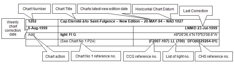
The last correction number is identified with the LNM/D or Last Notice to Mariners Number / Date. This number is expressed in either old notice number format (ex.: 594/99) or in day-month-year format which is the date known as the weekly chart correction date shown in the above diagram as item (8).
MONTHLY EDITION OF NOTICES TO MARINERS WEB ACCESS
We are offering a feature where subscribers to our on-line service are able to receive the complete electronic monthly edition of
our Notices to Mariners. We are encouraging our clients to visit the web site to subscribe for this service:
http://www.notmar.gc.ca/subscribe/
Users wishing to receive information updates for their charts can do so by setting up a ’User Profile’ on the following web page http://www.notmar.gc.ca/search/mycharts-eng.php?czoxOToibnRtPXN0ZXBfb25lJmxhbmc9ZSI7
This feature permits users to register the nautical charts they currently have in their possession. Registrants are then automatically notified by e-mail when a Notice to Mariners is published concerning these charts.
ADVISORY
NOTICES TO SHIPPING (WRITTEN AND BROADCAST)
The Canadian Coast Guard is implementing a number of changes to the aids to navigation system in Canada.
These changes are advertised as Notices to Shipping (Broadcast and Written) by the Canadian Coast Guard and are followed up with Notices to Mariners, then charts are updated by hand correction, reprints or new editions.
Mariners are advised that all relevant Written Notices to Shipping should be kept until superseded by Notices to Mariners or through revised charts issued by the Canadian Hydrographic Service.
Written Notices to Shipping are available on the Canadian Coast Guard Website at: www.ccg-gcc.gc.ca/eng/CCG/NOTSHIP.
The Canadian Hydrographic Service is reviewing the impact of these changes with the Canadian Coast Guard and together we are preparing an action plan on the issuing of chart revisions.
For further information contact your local Regional Notices to Shipping (NOTSHIP) issuing authorities.
| WESTERN |
|
| Fisheries and Oceans Canada | * Fisheries and Oceans Canada |
| Canadian Coast Guard | Canadian Coast Guard |
| Victoria MCTS Centre | Iqaluit MCTS Centre |
| P.O. Box 6000 | Notices to Shipping Series "A" and Series"H" |
| 9860 West Saanich Road | P.O. Box 189 |
| SIDNEY, BC, V8L 4B2 | IQALUIT, NU, X0A 0H0 |
| Telephone: (250) 363-6333 | Telephone: (867) 979-5269 Facsimile: (867) 979-4264 |
| Email: supervisor.Victoria@innav.gc.ca | Email: IQANORDREG@INNAV.GC.CA |
| Web site: http://www.ccg-gcc.gc.ca/Marine-communications/Home | Web site: http://www.ccg-gcc.gc.ca/fra/GCC/Accueil-notship |
* Services provided in English and French
INDEX
| CANADIAN HYDROGRAPHIC SERVICE - ANNOUNCEMENT REGARDING CANADIAN HYDROGRAPHIC SERVICE CHART PATCHES | 1 |
| CANADIAN HYDROGRAPHIC SERVICE - CUMULATIVE CHART CORRECTIONS | 1 |
| CANADIAN HYDROGRAPHIC SERVICE - CURRENT CHART EDITION DATES | 1 |
| CANADIAN HYDROGRAPHIC SERVICE - PRINT ON DEMAND CHARTS - CARE AND USE | 1 |
| CANADIAN HYDROGRAPHIC SERVICE - TRANSPORT CANADA NAVIGATION SAFETY – ECDIS | 2 |
| UPDATE TO CONSOLIDATION OF MARINE COMMUNICATIONS AND TRAFFIC SERVICES (MCTS) CENTRES | 2 |
| *401 CANADIAN HYDROGRAPHIC SERVICE - NAUTICAL CHARTS | 3 |
| *402 CANADIAN HYDROGRAPHIC SERVICE - ELECTRONIC NAVIGATIONAL CHARTS | 3 |
| *403 CANADIAN HYDROGRAPHIC SERVICE - RASTER DIGITAL CHARTS (BSB V4) | 3 |
| *404 CANADIAN COAST GUARD - LIST OF CHARTS AND REFERENCE CHARTS (SECTION I) AFFECTED BY TEMPORARY AND PRELIMINARY NOTICES | 4 |
| *405 CANADIAN COAST GUARD PUBLICATION – ANNUAL EDITION OF NOTICES TO MARINERS 2016 | 5 |
| *406 CANADIAN COAST GUARD PUBLICATIONS - NEW EDITION OF RADIO AIDS TO MARINE NAVIGATION (PACIFC AND ARCTIC) – 2016 | 5 |
| *407 CANADIAN HYDROGRAPHIC SERVICE – ANNOUNCEMENT REGARDING TIDAL INFORMATION TABLES ON CHARTS | 5 |
|
NUMERICAL INDEX OF CANADIAN CHARTS AFFECTED
|
|||||
|
Chart No. |
Page |
Chart No. |
Page |
Chart No. |
Page |
| 3601 | 7 | 3955 | 10, 11 | ||
| 1435 | 3 | 3742 | 7 | 3956 | 11, 12, 13 |
| 3002 | 6 | 3744 | 7 | 3957 | 13, 14, 15, 16 |
| 3311 | 6 | 3800 | 8 | 3958 | 16, 17, 18, 19 |
| 3312 | 6 | 3902 | 8 | 3986 | 19 |
| 3313 | 6 | 3927 | 8 | 4202 | 3 |
| 3461 | 7 | 3939 | 8 | 4954 | 3 |
| 3478 | 7 | 3940 | 8 | 5429 | 3 |
| 3538 | 7 | 3947 | 8, 9, 10 | ||
CANADIAN HYDROGRAPHIC SERVICE - ANNOUNCEMENT REGARDING CANADIAN HYDROGRAPHIC SERVICE CHART PATCHES.
Colour Web Patches are free to the mariner, and given the quality of many printers, should reproduce well. They will be available in real time all around the world.
CHS welcomes your feedback on this service at chsinfo@dfo-mpo.gc.ca
CANADIAN HYDROGRAPHIC SERVICE - CUMULATIVE CHART CORRECTIONS.
The cumulative Notices to Mariners corrections for charts can now be accessed at
www.notmar.gc.ca/search/notmar-eng.php
CANADIAN HYDROGRAPHIC SERVICE - Current chart edition dates.
CHART EDITIONS
The three terms described below are used to indicate the publication status of Canadian charts.
NEW CHART - "NEWCHT"
The first publication of a Canadian chart embracing an area not previously charted to the scale shown, or embracing an area different from any existing Canadian chart.
NEW EDITION - "NEWEDT"
A new issue of an existing chart containing amendments essential to navigation in addition to those issued in Notices to Mariners and making existing editions obsolete.
REPRINTS
A new issue of the current edition of a chart incorporating no amendments of navigational significance other than those previously promulgated in Notices to Mariners. It may also contain amendments from other sources provided they are not essential to navigation. Previous printings of the current edition remain in force
The current chart edition dates can be accessed at www.chs-shc.gc.ca/charts-cartes/paper-papier/index-eng.asp
CANADIAN HYDROGRAPHIC SERVICE - PRINT ON DEMAND CHARTS - CARE AND USE.
Background
By providing nautical charts to the public, the goal of the Canadian Hydrographic Service (CHS) is to provide services for safe navigation in a fiscally responsible manner. As a result, CHS continues to expand its portfolio of nautical paper charts that are printed using Print On Demand (POD) technology. These charts are easily recognized by their whiter paper and the coloured logo of the Canadian Hydrographic Service. This new technology enables CHS to print charts in a more efficient manner while enhancing chart content through being able to quickly add new and important information. POD technology provides customers with up-to-date charts without the historical hand-drawn corrections or glued-on patches. Additionally, this technology eliminates out-of-stock situations which arise with the traditional printing and warehousing methods. In the event of a national emergency, CHS can respond to the appropriate authorities with best available information very quickly.
Care of Your POD Chart
CHS encourages its customers to handle the POD charts more carefully than the traditional lithographic charts. When plotting information on POD charts, use HB pencils and apply limited pressure. Testing has suggested that an Indian gum eraser is more effective than alternatives when used on the product. This eraser is also suitable for charts printed using lithographic processes.
CANADIAN HYDROGRAPHIC SERVICE - TRANSPORT CANADA NAVIGATION SAFETY - ECDIS.
Mariners are advised that ECDIS may not display some isolated shoal depths when operating in "base or standard display" mode. Route planning and monitoring alarms for these shoal depths may not always be activated. To ensure safe navigation and to confirm that a planned route is clear of such dangers, mariners should visually inspect the planned route and any deviations from it using ECDIS configured to display "all data". The automated voyage planning check function should not be solely relied upon.
UPDATE TO CONSOLIDATION OF MARINE COMMUNICATIONS AND TRAFFIC SERVICES (MCTS) CENTRES
The Canadian Coast Guard is modernizing and consolidating its Marine Communications and Traffic Services Centres. Clients will continue to receive the high-quality service they have come to expect.
Once complete, there will be a total of 12 MCTS Centres strategically located across the country. Additional information pertaining to this project will be advertised to clients by all available means.
Western Region
Comox MCTS will consolidate to Victoria MCTS in Winter/Spring 2016
The new technology will increase efficiency permitting employees to have a greater ability to focus on the safety services they provide to mariners. Mariners are encouraged to visit the Radio Aids to Marine Navigation (RAMN) http://www.ccg-gcc.gc.ca/Marine-Communications/Homeand Notices to Mariners (NOTMAR)http://www.notmar.gc.ca/ PART 3 on a monthly basis for updated information and potential changes to contact information and marine broadcast schedules.
*401 CANADIAN HYDROGRAPHIC SERVICE - NAUTICAL CHARTS
| CHARTS | MAIN TITLE | SCALE | PUBLISHED | CAT# | PRICE |
| New Charts | |||||
| 5429 | Plans du Détroit D’Hudson/Plans of Hudson Strait | 1:10000 | 06-NOV-2015 | 4 | 20 |
| New Editions | |||||
| 1* | Chart/Carte 1: Symbols Abbreviations Terms/Signes Conventionnels Abréviations Termes | 01-MAR-2016 | N/A | 6.00 | |
| 1435 | Cardinal to/à Whaleback Shoal | 1:25000 | 26-JUN-2015 | 3 | 20.00 |
| 4202 | Halifax Harbour – Point Pleasant to/à Bedford Basin | 1:10000 | 26-FEB-2016 | 1 | 20.00 |
| 4954 | Chenal du Havre de la Grande Entrée | 1:15000 | 18-MAR-2016 | 1 | 20.00 |
*The 2016 edition of Chart 1 is now available in PDF and HTML at no cost, from http://www.charts.gc.ca/publications/chart1-carte1/index-eng.asp. The HTML version of this edition, has been upgraded to display in mobile devices.
*402 SCANADIAN HYDROGRAPHIC SERVICE - ELECTRONIC NAVIGATIONAL CHARTS
| NEW PRODUCTS | |
| S-57 ENC NUMBER |
CHART TITLE |
| CA376296 | Cape St Mary's to/à Argentia |
| CA476657 | Botwood and Approaches/et les approches |
| CA476658 | Continuation A:Northerm Arm |
| CA573478 | Hat Island |
| CA576297 | St. Brides |
| CA576298 | Argentia |
| CA576299 | Placentia Road |
| CA576659 | Botwood |
| CA670732 | Chemainus |
*403 CANADIAN HYDROGRAPHIC SERVICE - RASTER DIGITAL CHARTS (BSB V4)
| CHARTS | MAIN TITLE | SCALE | PUBLISHED |
| New Charts | |||
| RM-5429 | Plans du Détroit D'Hudson/Plans of Hudson Strait | 1:10000 | 06-NOV-2015 |
| New Editions | |||
| RM-3912 | Plans, Vicinity of/Proximité de Banks Island | 1:25000 | 14-AUG-2015 |
| RM-4202 | Halifax Harbour - Point Pleasant to/à Bedford Basin | 1:10000 | 26-FEB-2016 |
| RM-7511 | Resolute Passage | 1:50000 | 23-OCT-2015 |
*404 CANADIAN COAST GUARD - LIST OF CHARTS AND REFERENCE CHARTS (SECTION I) AFFECTED BY TEMPORARY AND PRELIMINARY NOTICES.
IN EFFECT APRIL 29th, 2016
(REVISED AND PROMULGATED QUARTERLY)
| 1430 | 809(P)/15 |
| 2017 | 909(T)/14 |
| 2044 | 1005(T)/15 |
| 2315 | 1006(T)/15 |
| 3057 | 209(P)/16 |
| 3478 | 1013(P)/15 |
| 3490 | 1112(P)/14 213(P)/15 |
| 3538 | 712(P)/15 |
| 3546 | 714(P)/14 |
| 3668 | 1213(P)/14 |
| 3800 | 115(P)/16 |
| 4010 | 605(P)/14 1108(P)/15 |
| 4170 | 1109(P)/15 |
| 4201 | 509(P)/13 |
| 4211 | 1205(P)/15 |
| 4233 | 1204(P)/15 112(P)/16 |
| 4236 | 609(P)/15 610(P)/15 |
| 4241 | 810(P)/14 808(P)/15 |
| 4244 | 1006(T)/14 904(P)/15 |
| 4302 | 303(T)/16 |
| 4340 | 418(P)/14 |
| 4367 | 1008(P)/15 |
| 4374 | 508(P)/15 |
| 4375 | 411(P)/15 1004(P)/15 113(P)/16 |
| 4376 | 302(P)/16 |
| 4377 | 405(P)/13 |
| 4385 | 202(P)/15 |
| 4386 | 1108(P)/13 507(P)/14 |
| 4396 | 709(P)/14 |
| 4422 | 1005(P)/14 |
| 4512 | 1007(P)/15 |
| 4597 | 1003(P)/09 |
| 4644 | 1106(T)/15 |
| 4670 | 111(P)/16 |
| 4825 | 110(T)/16 |
| 4830 | 1104(T)/13 |
| 4863 | 109(T)/16 |
| 4909 | 613(P)/12 810(P)/12 |
| 4911 | 510(P)/15 811(P)/12 515(P)/15 |
| 4912 | 516(P)/15 |
| 5051 | 1208(T)/13 |
| 6218 | 204(T)/16 |
| 6267 | 1114(P)/14 |
| US 14832 | 712(T)/14 |
| US 14884 | 715(T)/13 |
| US 14853 | 1211(T)/14 |
| US 14865 | 807(T)/15 |
*405 CANADIAN COAST GUARD PUBLICATION – ANNUAL EDITION OF NOTICES TO MARINERS 2016.
The 2016 Annual Edition of Notices to Mariners is now available for free download, on the NOTMAR web site at http://www.notmar.gc.ca/go.php?doc=eng/services/annual/default-eng
Paper copies of this publication will no longer be sold. This printable online version is always up-to-date.
Amendments to this publication are advertised in the Section 1 of the monthly edition of Notices to Mariners (www.notmar.gc.ca).
The 2016 edition has been revised up to Edition 12, 2015 and supersedes the 2015 edition.
*406 CANADIAN COAST GUARD PUBLICATIONS - NEW EDITION OF RADIO AIDS TO MARINE NAVIGATION (PACIFC AND ARCTIC) – 2016.
The 2016 edition of the Radio Aids to Marine Navigation (Pacific and Arctic) is now available for download, free of charge, on the Marine Communications and Traffic Services MCTS website: http://www.ccg-gcc.gc.ca/Marine-Communications/Home
Paper copies of the publication are no longer sold.
Amendments to this publication are advertised by radio broadcast (Notices to Shipping) and/or in Section 3 of the monthly edition of Notices to Mariners www.notmar.gc.ca
The 2016 edition has been revised to April 29, 2016 and supersedes the 2015 edition.
*407 CANADIAN HYDROGRAPHIC SERVICE – ANNOUNCEMENT REGARDING TIDAL INFORMATION TABLES ON CHARTS.
Mariners are advised that the tidal levels listed in the 2016 edition of Canadian Tide and Current Tables, volumes 2 and 3 have been updated. This revision is aimed to get more precise tidal predictions in time and height. This will result in corrections to theTidal Information Table shown on charts. These corrections will be published in 2016, through Notices to Mariners.
CHART CORRECTIONS
3002 - Queen Charlotte Sound to/à Dixon Entrance - New Edition - 16-DEC-1994 - NAD 1927
|
08-APR-2016 |
LNM/D. 25-MAR-2016 |
||
|
Amend |
Fl to read Fl 6s against light
|
53°38′04.8″N 130°33′52.4″W |
|
|
This notice affects Electronic Navigational Chart: CA270724, CA470622 |
|||
|
(P2016036) LL(742) DFO(6203243-01) |
|||
3311 - Grief Point to/à Desolation Sound - Sheet/Feuille 5 - New Edition - 31-DEC-1993 - NAD 1983
|
08-APR-2016 |
LNM/D. 04-MAR-2016 |
||
|
Delete |
radar reflector
|
50°05′37.3″N 125°02′16.2″W |
|
|
This notice affects Electronic Navigational Chart: CA470103 |
|||
|
(P2016041) LL(483) DFO(6203251-01) |
|||
3312 - Hoskyn Channel - Sutil Channel - Sheet/Feuille 19 - New Edition - 05-JAN-2007 - NAD 1983
|
08-APR-2016 |
LNM/D. 11-MAR-2016 |
||
|
Delete |
radar reflector
|
50°05′37.3″N 125°02′16.2″W |
|
|
This notice affects Electronic Navigational Chart: CA470103 |
|||
|
(P2016041) LL(483) DFO(6203251-01) |
|||
3313 - Juan de Fuca Strait - Sheet/Feuille 1 - New Edition - 02-JAN-2009 - NAD 1983
|
08-APR-2016 |
LNM/D. 11-MAR-2016 |
||
|
Delete |
light
|
48°19′06.5″N 122°50′37.7″W |
|
|
DFO(6203253-02) |
|||
|
Add |
light
|
48°19′14.4″N 122°49′51.5″W |
|
|
DFO(6203253-04) |
|||
3313 - Captain Passage - Sheet/Feuille 10 - New Edition - 02-JAN-2009 - NAD 1983
|
29-APR-2016 |
LNM/D. 15-APR-2016 |
||
|
Delete |
depth of 1.9 metres
|
48°51′16.6″N 123°29′56.7″W |
|
|
This notice affects Electronic Navigational Chart: CA570239 |
|||
|
DFO(6203258-01) |
|||
|
Add |
depth of 1.6 metres
|
48°51′16.6″N 123°29′56.5″W |
|
|
This notice affects Electronic Navigational Chart: CA570239 |
|||
|
DFO(6203258-02) |
|||
3313 - Nanaimo Harbour and/et Departure Bay - Sheet/Feuille 21 - New Edition - 02-JAN-2009 - NAD 1983
|
15-APR-2016 |
LNM/D. 08-APR-2016 |
||
|
Affix |
patch |
49°10′00.0″N 123°55′00.0″W |
|
|
Download Patch - http://www.chs-shc.gc.ca/patches/3313Patch_Nanaimo_layered.pdf |
|||
|
DFO(6203255-01) |
|||
3461 - Juan de Fuca Strait, Eastern Portion/Partie Est - New Edition - 01-JUL-2005 - NAD 1983
|
08-APR-2016 |
LNM/D. 19-JUN-2015 |
||
|
Delete |
light marked Fl 10s 30m 18M
|
48°19′06.5″N 122°50′37.7″W |
|
|
DFO(6203253-01) |
|||
|
Add |
light marked Fl 10s 17m 14M
|
48°19′14.4″N 122°49′51.5″W |
|
|
DFO(6203253-03) |
|||
3478 - Ganges Harbour and/et Long Harbour - New Edition - 12-JUL-2013 - NAD 1983
|
29-APR-2016 |
LNM/D. 08-JAN-2016 |
||
|
Delete |
depth of 1.9 metres
|
48°51′16.6″N 123°29′56.7″W |
|
|
This notice affects Electronic Navigational Chart: CA570239 |
|||
|
DFO(6203258-01) |
|||
|
Add |
depth of 1.6 metres
|
48°51′16.6″N 123°29′56.5″W |
|
|
This notice affects Electronic Navigational Chart: CA570239 |
|||
|
DFO(6203258-02) |
|||
3538 - Desolation Sound and/et Sutil Channel - New Edition - 30-DEC-2005 - NAD 1983
|
08-APR-2016 |
LNM/D. 25-MAR-2016 |
||
|
Delete |
radar reflector
|
50°05′37.3″N 125°02′16.2″W |
|
|
This notice affects Electronic Navigational Chart: CA470103 |
|||
|
(P2016041) LL(483) DFO(6203251-01) |
|||
3601 - Juan de Fuca Strait to/à Vancouver Harbour - New Edition - 01-JUL-2005 - NAD 1983
|
08-APR-2016 |
LNM/D. 01-JAN-2016 |
||
|
Delete |
light
|
48°19′06.5″N 122°50′37.7″W |
|
|
DFO(6203253-02) |
|||
|
Add |
light
|
48°19′14.4″N 122°49′51.5″W |
|
|
DFO(6203253-04) |
|||
3742 - Otter Passage to/à McKay Reach - New Edition - 16-JUL-1982 - NAD 1927
|
08-APR-2016 |
LNM/D. 25-MAR-2016 |
||
|
Amend |
Fl to read Fl 6s against light
|
53°18′43.0″N 129°07′15.0″W |
|
|
(P2016034) LL(650) DFO(6203241-01) |
|||
3744 - Queen Charlotte Sound - New Edition - 20-MAY-1988 - NAD 1927
|
08-APR-2016 |
LNM/D. 25-MAR-2016 |
||
|
Amend |
Fl to read Fl 6s against light
|
53°38′05.6″N 130°33′46.4″W |
|
|
This notice affects Electronic Navigational Chart: CA270724, CA470622 |
|||
|
(P2016036) LL(742) DFO(6203243-01) |
|||
3800 - Dixon Entrance - New Chart - 06-MAY-2011 - NAD 1983
|
08-APR-2016 |
LNM/D. 25-MAR-2016 |
||
|
Amend |
Fl 6s13m5M to read Fl 6s10m7M against light
|
53°38′04.8″N 130°33′52.4″W |
|
|
This notice affects Electronic Navigational Chart: CA270724, CA470622 |
|||
|
(P2016036) LL(742) DFO(6203243-01) |
|||
3902 - Hecate Strait - New Edition - 09-DEC-1988 - NAD 1927
|
08-APR-2016 |
LNM/D. 25-MAR-2016 |
||
|
Amend |
Fl to read Fl 6s against light
|
53°38′05.6″N 130°33′46.4″W |
|
|
This notice affects Electronic Navigational Chart: CA270724, CA470622 |
|||
|
(P2016036) LL(742) DFO(6203243-01) |
|||
3927 - Bonilla Island to/à Edye Passage - New Edition - 29-MAY-1998 - NAD 1983
|
08-APR-2016 |
LNM/D. 25-MAR-2016 |
||
|
Amend |
Fl 6s41ft5M to read Fl 6s33ft7M against light
|
53°38′04.8″N 130°33′52.4″W |
|
|
This notice affects Electronic Navigational Chart: CA270724, CA470622 |
|||
|
(P2016036) LL(742) DFO(6203243-01) |
|||
3939 - Fisher Channel to/à Seaforth Channel and/et Dean Channel - New Edition - 01-AUG-2014 - WGS84
|
15-APR-2016 |
LNM/D. 04-MAR-2016 |
||
|
Amend |
Fl to read Fl 6s against light
|
52°17′36.3″N 128°05′59.0″W |
|
|
This notice affects Electronic Navigational Chart: CA470087 |
|||
|
(P2016023) LL(605) DFO(6203229-01) |
|||
3940 - Spiller Channel and/et Roscoe Inlet - New Chart - 01-MAR-1996 - NAD 1983
|
15-APR-2016 |
LNM/D. 12-SEP-2008 |
||
|
Amend |
Fl to read Fl 6s against light
|
52°17′36.3″N 128°05′59.0″W |
|
|
This notice affects Electronic Navigational Chart: CA470087 |
|||
|
(P2016023) LL(605) DFO(6203229-01) |
|||
3947 - Grenville Channel to/à Chatham Sound - New Chart - 25-DEC-2009 - NAD 1983
|
22-APR-2016 |
LNM/D. 08-APR-2016 |
||
|
Delete |
depth of 0.3 metres
|
54°10′30.3″N 130°18′47.0″W |
|
|
This notice affects Electronic Navigational Chart: CA470597, CA570125 |
|||
|
DFO(6203256-01) |
|||
|
Add |
rock which covers and uncovers with drying height of 0.1 metres
|
54°10′30.8″N 130°18′46.6″W |
|
|
This notice affects Electronic Navigational Chart: CA470597, CA570125 |
|||
|
DFO(6203256-02) |
|||
|
Add |
rock which covers and uncovers with drying height of 0.4 metres
|
54°11′40.1″N 130°17′48.7″W |
|
|
This notice affects Electronic Navigational Chart: CA470597, CA570125 |
|||
|
DFO(6203256-03) |
|||
|
Add |
rock which covers and uncovers with drying height of 0.7 metres
|
54°11′35.0″N 130°17′39.8″W |
|
|
This notice affects Electronic Navigational Chart: CA470597 |
|||
|
DFO(6203256-07) |
|||
|
Add |
depth of 0.8 metres
|
54°10′27.2″N 130°18′54.6″W |
|
|
This notice affects Electronic Navigational Chart: CA470597, CA570125 |
|||
|
DFO(6203256-10) |
|||
|
Delete |
depth of 1.5 metres
|
54°10′15.5″N 130°18′44.9″W |
|
|
This notice affects Electronic Navigational Chart: CA470597, CA570125 |
|||
|
DFO(6203256-13) |
|||
|
Add |
depth of 0.9 metres
|
54°10′15.5″N 130°18′45.2″W |
|
|
This notice affects Electronic Navigational Chart: CA470597, CA570125 |
|||
|
DFO(6203256-14) |
|||
|
Add |
depth of 3.0 metres
|
54°10′27.2″N 130°19′02.6″W |
|
|
This notice affects Electronic Navigational Chart: CA470597, CA570125 |
|||
|
DFO(6203256-16) |
|||
|
Add |
depth of 2.9 metres
|
54°10′12.1″N 130°19′12.9″W |
|
|
This notice affects Electronic Navigational Chart: CA470597, CA570125 |
|||
|
DFO(6203256-18) |
|||
|
Add |
depth of 7.6 metres
|
54°10′12.6″N 130°19′18.8″W |
|
|
This notice affects Electronic Navigational Chart: CA470597, CA570125 |
|||
|
DFO(6203256-20) |
|||
|
Add |
depth of 7.8 metres
|
54°10′08.5″N 130°19′20.3″W |
|
|
This notice affects Electronic Navigational Chart: CA470597, CA570125 |
|||
|
DFO(6203256-21) |
|||
|
Delete |
depth of 7.6 metres
|
54°10′04.2″N 130°19′15.7″W |
|
|
This notice affects Electronic Navigational Chart: CA470597, CA570125 |
|||
|
DFO(6203256-22) |
|||
|
Add |
depth of 3.9 metres
|
54°10′04.0″N 130°19′14.2″W |
|
|
This notice affects Electronic Navigational Chart: CA470597, CA570125 |
|||
|
DFO(6203256-23) |
|||
|
Add |
depth of 4.6 metres
|
54°09′48.2″N 130°19′00.0″W |
|
|
This notice affects Electronic Navigational Chart: CA470597, CA570125 |
|||
|
DFO(6203256-26) |
|||
|
Delete |
depth of 12.5 metres
|
54°09′35.2″N 130°18′37.6″W |
|
|
This notice affects Electronic Navigational Chart: CA470597, CA570125 |
|||
|
DFO(6203256-27) |
|||
|
Add |
depth of 9.3 metres
|
54°09′35.7″N 130°18′36.8″W |
|
|
This notice affects Electronic Navigational Chart: CA470597, CA570125 |
|||
|
DFO(6203256-28) |
|||
|
08-APR-2016 |
LNM/D. 12-FEB-2016 |
||
|
Delete |
depth of 1.2 metres
|
54°10′36.8″N 130°22′51.2″W |
|
|
This notice affects Electronic Navigational Chart: CA470597, CA570125 |
|||
|
DFO(6203254-09) |
|||
|
Add |
depth of 0.6 metres
|
54°10′36.5″N 130°22′51.3″W |
|
|
This notice affects Electronic Navigational Chart: CA470597, CA570125 |
|||
|
DFO(6203254-10) |
|||
|
Delete |
depth of 6.4 metres
|
54°10′41.1″N 130°22′30.0″W |
|
|
This notice affects Electronic Navigational Chart: CA470597, CA570125 |
|||
|
DFO(6203254-11) |
|||
|
Add |
depth of 4.4 metres
|
54°10′40.7″N 130°22′27.4″W |
|
|
This notice affects Electronic Navigational Chart: CA470597, CA570125 |
|||
|
DFO(6203254-12) |
|||
3955 - Porpoise Harbour, Ridley Island and Approaches/et les Approches - New Edition - 21-FEB-2014 - WGS84
|
22-APR-2016 |
LNM/D. 25-MAR-2016 |
||
|
Add |
rock which covers and uncovers with drying height of 0.4 metres
|
54°11′40.1″N 130°17′48.7″W |
|
|
This notice affects Electronic Navigational Chart: CA470597, CA570125 |
|||
|
DFO(6203256-03) |
|||
|
Delete |
depth of 1.5 metres
|
54°11′54.8″N 130°18′00.1″W |
|
|
This notice affects Electronic Navigational Chart: CA570125 |
|||
|
DFO(6203256-04) |
|||
|
Add |
rock which covers and uncovers with drying height of 0.6 metres
|
54°11′54.7″N 130°18′00.0″W |
|
|
This notice affects Electronic Navigational Chart: CA570125 |
|||
|
DFO(6203256-05) |
|||
|
Delete |
depth of 3.0 metres
|
54°11′35.0″N 130°17′39.8″W |
|
|
This notice affects Electronic Navigational Chart: CA570125 |
|||
|
DFO(6203256-06) |
|||
|
Add |
rock which covers and uncovers with drying height of 0.7 metres
|
54°11′35.0″N 130°17′39.8″W |
|
|
This notice affects Electronic Navigational Chart: CA470597 |
|||
|
DFO(6203256-07) |
|||
3955 - Venn Passage - New Edition - 21-FEB-2014 - WGS84
|
29-APR-2016 |
LNM/D. 22-APR-2016 |
||
|
Delete |
submarine pipeline
|
between 54°20′09.5″N 130°26′28.3″W and 54°20′03.2″N 130°26′20.5″W |
|
|
This notice affects Electronic Navigational Chart: CA570715 |
|||
|
DFO(6203257-01) |
|||
|
Add |
submarine pipeline
|
joining 54°20′09.2″N 130°26′28.5″W 54°20′07.9″N 130°26′27.9″W 54°20′05.6″N 130°26′21.1″W and 54°20′04.9″N 130°26′14.8″W |
|
|
DFO(6203257-02) |
|||
3956 - Malacca Passage to/à Bell Passage - New Edition - 01-MAR-1996 - NAD 1983
|
22-APR-2016 |
LNM/D. 08-APR-2016 |
||
|
Delete |
depth of 0.3 metres
|
54°10′30.3″N 130°18′47.0″W |
|
|
This notice affects Electronic Navigational Chart: CA470597, CA570125 |
|||
|
DFO(6203256-01) |
|||
|
Add |
rock which covers and uncovers with drying height of 0.1 metres
|
54°10′30.8″N 130°18′46.6″W |
|
|
This notice affects Electronic Navigational Chart: CA470597, CA570125 |
|||
|
DFO(6203256-02) |
|||
|
Add |
rock which covers and uncovers with drying height of 0.4 metres
|
54°11′40.1″N 130°17′48.7″W |
|
|
This notice affects Electronic Navigational Chart: CA470597, CA570125 |
|||
|
DFO(6203256-03) |
|||
|
Delete |
depth of 1.5 metres
|
54°11′54.5″N 130°17′59.2″W |
|
|
This notice affects Electronic Navigational Chart: CA570125 |
|||
|
DFO(6203256-04) |
|||
|
Add |
rock which covers and uncovers with drying height of 0.6 metres
|
54°11′54.7″N 130°18′00.0″W |
|
|
This notice affects Electronic Navigational Chart: CA570125 |
|||
|
DFO(6203256-05) |
|||
|
Add |
rock which covers and uncovers with drying height of 0.7 metres
|
54°11′35.0″N 130°17′39.8″W |
|
|
This notice affects Electronic Navigational Chart: CA470597 |
|||
|
DFO(6203256-07) |
|||
|
Add |
depth of 0.8 metres
|
54°10′27.2″N 130°18′54.6″W |
|
|
This notice affects Electronic Navigational Chart: CA470597, CA570125 |
|||
|
DFO(6203256-10) |
|||
|
Delete |
depth of 1.5 metres
|
54°10′15.5″N 130°18′44.4″W |
|
|
This notice affects Electronic Navigational Chart: CA470597, CA570125 |
|||
|
DFO(6203256-13) |
|||
|
Add |
depth of 0.9 metres
|
54°10′15.5″N 130°18′45.2″W |
|
|
This notice affects Electronic Navigational Chart: CA470597, CA570125 |
|||
|
DFO(6203256-14) |
|||
|
Delete |
depth of 4.0 metres
|
54°10′27.3″N 130°19′03.4″W |
|
|
This notice affects Electronic Navigational Chart: CA570125 |
|||
|
DFO(6203256-15) |
|||
|
Add |
depth of 3.0 metres
|
54°10′27.2″N 130°19′02.6″W |
|
|
This notice affects Electronic Navigational Chart: CA470597, CA570125 |
|||
|
DFO(6203256-16) |
|||
|
Delete |
depth of 5.2 metres
|
54°10′12.1″N 130°19′13.7″W |
|
|
This notice affects Electronic Navigational Chart: CA570125 |
|||
|
DFO(6203256-17) |
|||
|
Add |
depth of 2.9 metres
|
54°10′12.1″N 130°19′12.9″W |
|
|
This notice affects Electronic Navigational Chart: CA470597, CA570125 |
|||
|
DFO(6203256-18) |
|||
|
Add |
depth of 7.6 metres
|
54°10′12.6″N 130°19′18.8″W |
|
|
This notice affects Electronic Navigational Chart: CA470597, CA570125 |
|||
|
DFO(6203256-20) |
|||
|
Add |
depth of 7.8 metres
|
54°10′08.5″N 130°19′20.3″W |
|
|
This notice affects Electronic Navigational Chart: CA470597, CA570125 |
|||
|
DFO(6203256-21) |
|||
|
Delete |
depth of 7.6 metres
|
54°10′04.2″N 130°19′15.7″W |
|
|
This notice affects Electronic Navigational Chart: CA470597, CA570125 |
|||
|
DFO(6203256-22) |
|||
|
Add |
depth of 3.9 metres
|
54°10′04.0″N 130°19′14.2″W |
|
|
This notice affects Electronic Navigational Chart: CA470597, CA570125 |
|||
|
DFO(6203256-23) |
|||
|
Delete |
depth of 5.8 metres
|
54°09′48.4″N 130°18′59.3″W |
|
|
This notice affects Electronic Navigational Chart: CA570125 |
|||
|
DFO(6203256-25) |
|||
|
Add |
depth of 4.6 metres
|
54°09′48.2″N 130°19′00.0″W |
|
|
This notice affects Electronic Navigational Chart: CA470597, CA570125 |
|||
|
DFO(6203256-26) |
|||
|
Delete |
depth of 12.5 metres
|
54°09′35.2″N 130°18′37.6″W |
|
|
This notice affects Electronic Navigational Chart: CA470597, CA570125 |
|||
|
DFO(6203256-27) |
|||
|
Add |
depth of 9.3 metres
|
54°09′35.7″N 130°18′36.8″W |
|
|
This notice affects Electronic Navigational Chart: CA470597, CA570125 |
|||
|
DFO(6203256-28) |
|||
|
08-APR-2016 |
LNM/D. 01-APR-2016 |
||
|
Delete |
depth of 3.0 metres
|
54°10′46.3″N 130°24′51.4″W |
|
|
This notice affects Electronic Navigational Chart: CA470315, CA570125 |
|||
|
DFO(6203254-03) |
|||
|
Add |
depth of 2.1 metres
|
54°10′45.7″N 130°24′50.3″W |
|
|
This notice affects Electronic Navigational Chart: CA470315, CA570125 |
|||
|
DFO(6203254-04) |
|||
|
Delete |
depth of 4.3 metres
|
54°10′50.5″N 130°25′00.8″W |
|
|
This notice affects Electronic Navigational Chart: CA470315, CA570125 |
|||
|
DFO(6203254-05) |
|||
|
Add |
depth of 3.3 metres
|
54°10′50.5″N 130°25′02.9″W |
|
|
This notice affects Electronic Navigational Chart: CA470315, CA570125 |
|||
|
DFO(6203254-06) |
|||
|
Delete |
depth of 1.2 metres
|
54°10′36.8″N 130°22′51.2″W |
|
|
This notice affects Electronic Navigational Chart: CA470597, CA570125 |
|||
|
DFO(6203254-09) |
|||
|
Add |
depth of 0.6 metres
|
54°10′36.5″N 130°22′51.3″W |
|
|
This notice affects Electronic Navigational Chart: CA470597, CA570125 |
|||
|
DFO(6203254-10) |
|||
|
Delete |
depth of 6.4 metres
|
54°10′41.1″N 130°22′30.0″W |
|
|
This notice affects Electronic Navigational Chart: CA470597, CA570125 |
|||
|
DFO(6203254-11) |
|||
|
Add |
depth of 4.4 metres
|
54°10′40.7″N 130°22′27.4″W |
|
|
This notice affects Electronic Navigational Chart: CA470597, CA570125 |
|||
|
DFO(6203254-12) |
|||
|
01-APR-2016 |
LNM/D. 25-MAR-2016 |
||
|
Add |
depth of 1.7 metres
|
54°12′46.8″N 130°25′14.3″W |
|
|
This notice affects Electronic Navigational Chart: CA470315, CA570125 |
|||
|
DFO(6203252-01) |
|||
3957 - Approaches to/Approches à Prince Rupert Harbour - New Edition - 05-JUN-1998 - NAD 1983
|
22-APR-2016 |
LNM/D. 08-APR-2016 |
||
|
Delete |
depth of 0.3 metres
|
54°10′29.8″N 130°18′42.7″W |
|
|
This notice affects Electronic Navigational Chart: CA470597, CA570125 |
|||
|
DFO(6203256-01) |
|||
|
Add |
rock which covers and uncovers with drying height of 0.1 metres
|
54°10′30.8″N 130°18′46.6″W |
|
|
This notice affects Electronic Navigational Chart: CA470597, CA570125 |
|||
|
DFO(6203256-02) |
|||
|
Add |
rock which covers and uncovers with drying height of 0.4 metres
|
54°11′40.1″N 130°17′48.7″W |
|
|
This notice affects Electronic Navigational Chart: CA470597, CA570125 |
|||
|
DFO(6203256-03) |
|||
|
Add |
rock which covers and uncovers with drying height of 0.7 metres
|
54°11′35.0″N 130°17′39.8″W |
|
|
This notice affects Electronic Navigational Chart: CA470597 |
|||
|
DFO(6203256-07) |
|||
|
Add |
depth of 0.8 metres
|
54°10′27.2″N 130°18′54.6″W |
|
|
This notice affects Electronic Navigational Chart: CA470597, CA570125 |
|||
|
DFO(6203256-10) |
|||
|
Delete |
depth of 1.5 metres
|
54°10′15.5″N 130°18′45.2″W |
|
|
This notice affects Electronic Navigational Chart: CA470597, CA570125 |
|||
|
DFO(6203256-13) |
|||
|
Add |
depth of 0.9 metres
|
54°10′15.5″N 130°18′45.2″W |
|
|
This notice affects Electronic Navigational Chart: CA470597, CA570125 |
|||
|
DFO(6203256-14) |
|||
|
Delete |
depth of 4.0 metres
|
54°10′27.3″N 130°19′03.4″W |
|
|
This notice affects Electronic Navigational Chart: CA570125 |
|||
|
DFO(6203256-15) |
|||
|
Add |
depth of 3.0 metres
|
54°10′27.2″N 130°19′02.6″W |
|
|
This notice affects Electronic Navigational Chart: CA470597, CA570125 |
|||
|
DFO(6203256-16) |
|||
|
Add |
depth of 2.9 metres
|
54°10′12.1″N 130°19′12.9″W |
|
|
This notice affects Electronic Navigational Chart: CA470597, CA570125 |
|||
|
DFO(6203256-18) |
|||
|
Delete |
depth of 17.7 metres
|
54°10′12.8″N 130°19′20.0″W |
|
|
This notice affects Electronic Navigational Chart: CA570125 |
|||
|
DFO(6203256-19) |
|||
|
Add |
depth of 7.6 metres
|
54°10′12.6″N 130°19′18.8″W |
|
|
This notice affects Electronic Navigational Chart: CA470597, CA570125 |
|||
|
DFO(6203256-20) |
|||
|
Add |
depth of 7.8 metres
|
54°10′08.5″N 130°19′20.3″W |
|
|
This notice affects Electronic Navigational Chart: CA470597, CA570125 |
|||
|
DFO(6203256-21) |
|||
|
Add |
depth of 3.9 metres
|
54°10′04.0″N 130°19′14.2″W |
|
|
This notice affects Electronic Navigational Chart: CA470597, CA570125 |
|||
|
DFO(6203256-23) |
|||
|
Add |
depth of 4.6 metres
|
54°09′48.2″N 130°19′00.0″W |
|
|
This notice affects Electronic Navigational Chart: CA470597, CA570125 |
|||
|
DFO(6203256-26) |
|||
|
Add |
depth of 9.3 metres
|
54°09′35.7″N 130°18′36.8″W |
|
|
This notice affects Electronic Navigational Chart: CA470597, CA570125 |
|||
|
DFO(6203256-28) |
|||
|
08-APR-2016 |
LNM/D. 01-APR-2016 |
||
|
Delete |
depth of 3.0 metres
|
54°10′46.3″N 130°24′51.4″W |
|
|
This notice affects Electronic Navigational Chart: CA470315, CA570125 |
|||
|
DFO(6203254-03) |
|||
|
Add |
depth of 2.1 metres
|
54°10′45.7″N 130°24′50.3″W |
|
|
This notice affects Electronic Navigational Chart: CA470315, CA570125 |
|||
|
DFO(6203254-04) |
|||
|
Delete |
depth of 4.3 metres
|
54°10′50.5″N 130°25′00.8″W |
|
|
This notice affects Electronic Navigational Chart: CA470315, CA570125 |
|||
|
DFO(6203254-05) |
|||
|
Add |
depth of 3.3 metres
|
54°10′50.5″N 130°25′02.9″W |
|
|
This notice affects Electronic Navigational Chart: CA470315, CA570125 |
|||
|
DFO(6203254-06) |
|||
|
Delete |
depth of 1.2 metres
|
54°10′36.8″N 130°22′51.2″W |
|
|
This notice affects Electronic Navigational Chart: CA470597, CA570125 |
|||
|
DFO(6203254-09) |
|||
|
Add |
depth of 0.6 metres
|
54°10′36.5″N 130°22′51.3″W |
|
|
This notice affects Electronic Navigational Chart: CA470597, CA570125 |
|||
|
DFO(6203254-10) |
|||
|
Delete |
depth of 6.4 metres
|
54°10′41.1″N 130°22′30.0″W |
|
|
This notice affects Electronic Navigational Chart: CA470597, CA570125 |
|||
|
DFO(6203254-11) |
|||
|
Add |
depth of 4.4 metres
|
54°10′40.7″N 130°22′27.4″W |
|
|
This notice affects Electronic Navigational Chart: CA470597, CA570125 |
|||
|
DFO(6203254-12) |
|||
|
01-APR-2016 |
LNM/D. 25-MAR-2016 |
||
|
Add |
depth of 1.7 metres
|
54°12′46.8″N 130°25′14.3″W |
|
|
This notice affects Electronic Navigational Chart: CA470315, CA570125 |
|||
|
DFO(6203252-01) |
|||
3958 - Prince Rupert Harbour - New Edition - 13-DEC-2013 - WGS84
|
22-APR-2016 |
LNM/D. 08-APR-2016 |
||
|
Delete |
depth of 0.3 metres
|
54°10′30.3″N 130°18′47.0″W |
|
|
This notice affects Electronic Navigational Chart: CA470597, CA570125 |
|||
|
DFO(6203256-01) |
|||
|
Add |
rock which covers and uncovers with drying height of 0.1 metres
|
54°10′30.8″N 130°18′46.6″W |
|
|
This notice affects Electronic Navigational Chart: CA470597, CA570125 |
|||
|
DFO(6203256-02) |
|||
|
Add |
rock which covers and uncovers with drying height of 0.4 metres
|
54°11′40.1″N 130°17′48.7″W |
|
|
This notice affects Electronic Navigational Chart: CA470597, CA570125 |
|||
|
DFO(6203256-03) |
|||
|
Delete |
depth of 1.5 metres
|
54°11′54.8″N 130°18′00.1″W |
|
|
This notice affects Electronic Navigational Chart: CA570125 |
|||
|
DFO(6203256-04) |
|||
|
Add |
rock which covers and uncovers with drying height of 0.6 metres
|
54°11′54.7″N 130°18′00.0″W |
|
|
This notice affects Electronic Navigational Chart: CA570125 |
|||
|
DFO(6203256-05) |
|||
|
Delete |
depth of 3.0 metres
|
54°11′35.0″N 130°17′39.8″W |
|
|
This notice affects Electronic Navigational Chart: CA570125 |
|||
|
DFO(6203256-06) |
|||
|
Add |
rock which covers and uncovers with drying height of 0.7 metres
|
54°11′35.0″N 130°17′39.8″W |
|
|
This notice affects Electronic Navigational Chart: CA470597 |
|||
|
DFO(6203256-07) |
|||
|
Delete |
depth of 1.2 metres
|
54°10′23.7″N 130°18′43.3″W |
|
|
This notice affects Electronic Navigational Chart: CA570125 |
|||
|
DFO(6203256-08) |
|||
|
Add |
depth of 0.8 metres
|
54°10′23.7″N 130°18′43.3″W |
|
|
This notice affects Electronic Navigational Chart: CA570125 |
|||
|
DFO(6203256-09) |
|||
|
Add |
depth of 0.8 metres
|
54°10′27.2″N 130°18′54.6″W |
|
|
This notice affects Electronic Navigational Chart: CA470597, CA570125 |
|||
|
DFO(6203256-10) |
|||
|
Delete |
depth of 1.5 metres
|
54°10′20.6″N 130°18′51.0″W |
|
|
This notice affects Electronic Navigational Chart: CA570125 |
|||
|
DFO(6203256-11) |
|||
|
Add |
depth of 0.9 metres
|
54°10′20.6″N 130°18′51.0″W |
|
|
This notice affects Electronic Navigational Chart: CA570125 |
|||
|
DFO(6203256-12) |
|||
|
Delete |
depth of 1.5 metres
|
54°10′15.5″N 130°18′44.4″W |
|
|
This notice affects Electronic Navigational Chart: CA470597, CA570125 |
|||
|
DFO(6203256-13) |
|||
|
Add |
depth of 0.9 metres
|
54°10′15.5″N 130°18′45.2″W |
|
|
This notice affects Electronic Navigational Chart: CA470597, CA570125 |
|||
|
DFO(6203256-14) |
|||
|
Delete |
depth of 4.0 metres
|
54°10′27.3″N 130°19′03.4″W |
|
|
This notice affects Electronic Navigational Chart: CA570125 |
|||
|
DFO(6203256-15) |
|||
|
Add |
depth of 3.0 metres
|
54°10′27.2″N 130°19′02.6″W |
|
|
This notice affects Electronic Navigational Chart: CA470597, CA570125 |
|||
|
DFO(6203256-16) |
|||
|
Delete |
depth of 5.2 metres
|
54°10′12.1″N 130°19′13.7″W |
|
|
This notice affects Electronic Navigational Chart: CA570125 |
|||
|
DFO(6203256-17) |
|||
|
Add |
depth of 2.9 metres
|
54°10′12.1″N 130°19′12.9″W |
|
|
This notice affects Electronic Navigational Chart: CA470597, CA570125 |
|||
|
DFO(6203256-18) |
|||
|
Delete |
depth of 17.7 metres
|
54°10′12.8″N 130°19′20.0″W |
|
|
This notice affects Electronic Navigational Chart: CA570125 |
|||
|
DFO(6203256-19) |
|||
|
Add |
depth of 7.6 metres
|
54°10′12.6″N 130°19′18.8″W |
|
|
This notice affects Electronic Navigational Chart: CA470597, CA570125 |
|||
|
DFO(6203256-20) |
|||
|
Add |
depth of 7.8 metres
|
54°10′08.5″N 130°19′20.3″W |
|
|
This notice affects Electronic Navigational Chart: CA470597, CA570125 |
|||
|
DFO(6203256-21) |
|||
|
Delete |
depth of 7.6 metres
|
54°10′04.2″N 130°19′15.7″W |
|
|
This notice affects Electronic Navigational Chart: CA470597, CA570125 |
|||
|
DFO(6203256-22) |
|||
|
Add |
depth of 3.9 metres
|
54°10′04.0″N 130°19′14.2″W |
|
|
This notice affects Electronic Navigational Chart: CA470597, CA570125 |
|||
|
DFO(6203256-23) |
|||
|
Delete |
depth of 9.4 metres
|
54°09′55.1″N 130°19′10.7″W |
|
|
This notice affects Electronic Navigational Chart: CA570125 |
|||
|
DFO(6203256-24) |
|||
|
Delete |
depth of 5.8 metres
|
54°09′48.4″N 130°18′59.3″W |
|
|
This notice affects Electronic Navigational Chart: CA570125 |
|||
|
DFO(6203256-25) |
|||
|
Add |
depth of 4.6 metres
|
54°09′48.2″N 130°19′00.0″W |
|
|
This notice affects Electronic Navigational Chart: CA470597, CA570125 |
|||
|
DFO(6203256-26) |
|||
|
Delete |
depth of 12.5 metres
|
54°09′35.2″N 130°18′37.6″W |
|
|
This notice affects Electronic Navigational Chart: CA470597, CA570125 |
|||
|
DFO(6203256-27) |
|||
|
Add |
depth of 9.3 metres
|
54°09′35.7″N 130°18′36.8″W |
|
|
This notice affects Electronic Navigational Chart: CA470597, CA570125 |
|||
|
DFO(6203256-28) |
|||
|
Add |
depth of 5.8 metres
|
54°09′55.4″N 130°19′10.5″W |
|
|
This notice affects Electronic Navigational Chart: CA570125 |
|||
|
DFO(6203256-29) |
|||
|
08-APR-2016 |
LNM/D. 01-APR-2016 |
||
|
Delete |
depth of 8.8 metres
|
54°10′40.8″N 130°24′52.5″W |
|
|
This notice affects Electronic Navigational Chart: CA570125 |
|||
|
DFO(6203254-01) |
|||
|
Add |
rock awash at chart datum
|
54°10′41.0″N 130°24′51.7″W |
|
|
This notice affects Electronic Navigational Chart: CA570125 |
|||
|
DFO(6203254-02) |
|||
|
Delete |
depth of 3.0 metres
|
54°10′46.3″N 130°24′51.4″W |
|
|
This notice affects Electronic Navigational Chart: CA470315, CA570125 |
|||
|
DFO(6203254-03) |
|||
|
Add |
depth of 2.1 metres
|
54°10′45.7″N 130°24′50.3″W |
|
|
This notice affects Electronic Navigational Chart: CA470315, CA570125 |
|||
|
DFO(6203254-04) |
|||
|
Delete |
depth of 4.3 metres
|
54°10′50.5″N 130°25′00.8″W |
|
|
This notice affects Electronic Navigational Chart: CA470315, CA570125 |
|||
|
DFO(6203254-05) |
|||
|
Add |
depth of 3.3 metres
|
54°10′50.5″N 130°25′02.9″W |
|
|
This notice affects Electronic Navigational Chart: CA470315, CA570125 |
|||
|
DFO(6203254-06) |
|||
|
Delete |
depth of 17.6 metres
|
54°10′35.8″N 130°24′53.8″W |
|
|
This notice affects Electronic Navigational Chart: CA570125 |
|||
|
DFO(6203254-07) |
|||
|
Add |
depth of 15.0 metres
|
54°10′35.5″N 130°24′53.4″W |
|
|
This notice affects Electronic Navigational Chart: CA570125 |
|||
|
DFO(6203254-08) |
|||
|
Delete |
depth of 1.2 metres
|
54°10′36.8″N 130°22′51.2″W |
|
|
This notice affects Electronic Navigational Chart: CA470597, CA570125 |
|||
|
DFO(6203254-09) |
|||
|
Add |
depth of 0.6 metres
|
54°10′36.5″N 130°22′51.3″W |
|
|
This notice affects Electronic Navigational Chart: CA470597, CA570125 |
|||
|
DFO(6203254-10) |
|||
|
Delete |
depth of 6.4 metres
|
54°10′41.1″N 130°22′30.0″W |
|
|
This notice affects Electronic Navigational Chart: CA470597, CA570125 |
|||
|
DFO(6203254-11) |
|||
|
Add |
depth of 4.4 metres
|
54°10′40.7″N 130°22′27.4″W |
|
|
This notice affects Electronic Navigational Chart: CA470597, CA570125 |
|||
|
DFO(6203254-12) |
|||
|
01-APR-2016 |
LNM/D. 25-MAR-2016 |
||
|
Add |
depth of 1.7 metres
|
54°12′46.8″N 130°25′14.3″W |
|
|
This notice affects Electronic Navigational Chart: CA470315, CA570125 |
|||
|
DFO(6203252-01) |
|||
3986 - Browning Entrance - New Chart - 25-DEC-2009 - NAD 1983
|
08-APR-2016 |
LNM/D. 25-MAR-2016 |
||
|
Amend |
Fl 6s13m5M to read Fl 6s10m7M against light
|
53°38′04.8″N 130°33′52.4″W |
|
|
This notice affects Electronic Navigational Chart: CA270724, CA470622 |
|||
|
(P2016036) LL(742) DFO(6203243-01) |
|||
CORRECTIONS TO RADIO AIDS TO MARINE NAVIGATION
SAILING DIRECTIONS AND SAMLL CRAFT GUIDE CORRECTIONS
LIST OF LIGHTS, BUOYS AND FOG SIGNALS CORRECTIONS
PACIFIC |
||||||||||
| No. | Name | Position --------- Latitude N. Longitude W. |
Light Characteristics | Focal Height in m. above water |
Nomi- nal Range |
Description --------- Heigth in meters above ground |
Remarks --------- Fog Signals |
|||
134.5 |
UVic Campbell ODAS buoy |
48 57 26.7 125 36 53.4 |
Fl(5) |
Y |
20s |
..... |
..... |
5(Flash 0.5 s; eclipse 1.5 s) Ec 10s Privately maintained. Year round. Chart: 3602 Edn 04/16 |
||
163 G5271 |
Stamp Narrows |
On W. side of narrows. 49 10 59.9 124 49 18 |
Q |
G |
1s |
9.7 |
4 |
White cylindrical tower, green band at top on 3-pile dolphin. |
Radar Reflector. Year round. Chart: 3668 Edn 04/16 (P16-027) |
|
227 G5345 |
James Island |
Off NW. point of island. 48 37 02.9 123 22 47.2 |
Fl |
W |
4s |
5.5 |
4 |
Mast on a 3-pile dolphin. |
Year round. Chart: 3479 Edn 04/16 (P16-029) |
|
413 G5477 |
Gosse Point |
Off S. shore. 49 17 32.8 122 55 30.5 |
Fl |
R |
4s |
8.6 |
5 |
White cylindrical tower, red band at top on 7-pile dolphin. |
Radar Reflector. Year round. Chart:3495 Edn 04/16 (P16-024) |
|
481 G5571 |
Cortes Bay |
50 03 46.5 124 55 30.1 |
Q |
R |
1s |
6.6 |
3 |
White cylindrical tower, red band at top. |
Year round. Chart:3538 Edn 04/16 (P16-040) |
|
483 G5570 |
Uganda Passage |
On Channel Rock between Shark Spit and Cortes Island. 50 05 37.3 125 02 16.2 |
Q |
R |
1s |
7 |
2 |
White square skeleton tower, red band at top. |
Year round. Chart:3538 Edn 04/16 (P16-041) |
|
605 G5702 |
Donald Point |
On the point, Return Channel. 52 17 36.3 128 05 59 |
Fl |
W |
6s |
5.7 |
5 |
White square skeleton tower. |
Flash 0.5 s; eclipse 5.5 s. Year round. Chart:3939 Edn 04/16 (P16-023) |
|
624.8 G5734.7 |
Walsh Rock |
52 38 14 128 57 15 |
Q |
W |
1s |
8.4 |
5 |
White cylindrical tower. |
Year round. Chart:3726 Edn 04/16 (P16-026) |
|
639.3 G5719.2 |
Wedge Point Sector light |
NE. tip of Cone Island. 52 36 37.4 128 31 06.5 |
F |
W R W |
..... |
4.8 |
5 |
Mast |
White 062° through E. to 168° Red 168° through S. to 181° White 181° to 198°. Year round. Chart:3911 Edn 04/16 (P16-028) |
|
640.5 G5721 |
Parry Patch - Sector light |
52 40 28.1 128 32 01.6 |
F |
W R W |
..... |
4.4 |
5 |
Mast |
White 352° through N. and E. to 130° Red 130° to 142° White 142° to 154°. Year round. Chart:3911 Edn 04/16 (P16-025) |
|
648 G5734 |
Kingcome Point |
N. extremity of point. 53 17 56.7 128 54 30.1 |
Q |
W |
1s |
7.6 |
5 |
White square skeleton tower. |
Year round. Chart:3944 Edn 04/16 (P16-039) |
|
650 G5736.8 |
Point Cumming |
On point, SW. end of Gribbell Island. 53 18 42.2 129 07 21.1 |
Fl |
W |
6s |
6.8 |
5 |
White square skeleton tower. |
Flash 0.5 s; eclipse 5.5 s. Year round. Chart:3945 Edn 04/16 (P16-034) |
|
651 G5739.4 |
Money Point |
On point. 53 22 54.5 129 09 56.5 |
Fl(3) |
W |
12s |
7.2 |
5 |
White square skeleton tower, white rectangular daymark. |
Flash 0.5 s; eclipse 2 s; Flash 0.5 s; eclipse 2 s; Flash 0.5 s; eclipse 6.5 s. Year round. Chart:3945 Edn 04/16 (P16-031) |
|
651.2 G5739.5 |
Hartley Bay, brise-lames |
End of boulder breakwater. Entrance to bay. 53 25 25.4 129 15 03.4 |
Q |
R |
1s |
10.1 |
3 |
White square skeleton tower, red band on top. |
Year round. Chart:3945 Edn 04/16 (P16-035) |
|
651.5 G5740.5 |
Harbour Rock |
Stewart Narrows. 53 23 16.3 129 16 38.5 |
Fl |
G |
4s |
3.4 |
5 |
Mast, green, white and black square daymark. |
Year round. Chart:3945 Edn 04/16 (P16-037) |
|
655 G5739.2 |
Dorothy Island |
On island. 53 39 33.7 128 50 37.5 |
Fl |
W |
6s |
7.4 |
5 |
White square skeleton tower. |
Flash 0.5 s; eclipse 5.5 s. Year round. Chart:3977 Edn 04/16 (P16-033) |
|
665.1 G5747.38 |
Plover Point |
53 16 44 129 18 15.6 |
Fl |
W |
4s |
7.1 |
7 |
White square skeleton tower. |
Year round. Chart:3945 Edn 04/16 (P16-038) |
|
742 G5749 |
Browning Entrance |
On N. island, White Rocks. 53 38 04.8 130 33 52.4 |
Fl |
W |
6s |
10.3 |
7 |
White square skeleton tower. |
Flash 0.5 s; eclipse 5.5 s. Year round. Chart:3986 Edn 04/16 (P16-036) |
|
Name of Ship or Sender:..................................................................... Date:....................................
Address of Sender:..........................................................................................................................
Street # Street Name
Town / City:.............................. Prov / State:....................... Postal Code / Zip Code: ........................
Tel / Fax / E-mail address of sender (if appropriate):............................................................................
Observation Date:............................................. Time (UTC): ...........................................................
Geographical Position:......................................................................................................................
Coordinate Position: Lat: ............................................... Long:.........................................................
Position Method: q DGPS q GPS with WAAS q GPS q Radar qOther
Horizontal Datum Used: qWGS 84 q NAD 27 q Other
Estimated Position Accuracy:............................................................................................................
Chart #:............................................................ Datum: q NAD 27 q NAD 83
Chart Edition:.................................................... Last Correction applied:............................................
Publications affected: (Quote Volume and page):.................................................................................
*Full details (Attach additional sheets as necessary)............................................................................
Mariners are requested to notify the responsible authorities when new or suspected dangers to navigation are discovered, changes are observed in aids to navigation, or corrections to publications are seen to be necessary.
In the case of new or suspected dangers to navigation, it is important that all details be given in order to aid with future investigations. Items of interest include heights, depths, physical description, type of bottom and equipment method used to position the item. It is helpful to mark details on chart, which will be promptly replaced by the Canadian Hydrographic Service.
Reports should be made to the nearest Marine Communications and Traffic Services Centre (MCTS) and should be confirmed in writing to:
|
Leader, Notices to Mariners Canadian Coast Guard Department of Fisheries and Oceans Mountréal, Qc H2Y 2E7 |
In the case of information concerning aids to navigation or the List of Lights, Buoys and Fog Signals. |
|
OR |
|
Dominion Hydrographer Canadian Hydrographic Service Department of Fisheries and Oceans Ottawa, Ontario, K1A 0E6 |
In the case of new or suspected dangers to navigation or where corrections to "Sailing Directions" appear to be necessary. |
Or general questions on Coast Guard programs or services please send an e-mail message to:
info@dfo-mpo.gc.ca (Please include your postal code and e-mail address).