
Archived information
The Standard on Web Usability replaces this content. This content is archived because Common Look and Feel 2.0 Standards have been rescinded.
Archived information is provided for reference, research or recordkeeping purposes. It is not subject to the Government of Canada Web Standards and has not been altered or updated since it was archived.
|
|
Fisheries and Oceans Canada |
Pêches et Ocèans Canada |
|
 |
|||
| MONTHLY EDITION N° 06 June 26th, 2015 |
|||
|
CONTENTS |
|||
Page |
|||
| Section 1 |
Safety and General Information | 1 - 9 |
|
| Section 2 |
Chart Corrections | 10 - 24 |
|
| Section 3 |
Radio Aids to Marine Navigation Corrections | 25 - 44 |
|
| Section 4 |
Sailing Directions and Small Craft Guide Corrections | 45 - 51 |
|
| Section 5 |
List of Lights, Buoys and Fog signals Corrections | 52 - 53 |
|
Maritime Services Directorate Aids to Navigation |
|||
Fisheries and Oceans Canada - Official publication of the Canadian Coast Guard |
|||
Geographical positions refer directly to the graduations of the largest scale Canadian Hydrographic chart unless otherwise indicated.
Bearings refer to the true compass and are measured clockwise from 000° (North) clockwise to 359°; those relating to lights are from seaward.
Visibility of lights is that in clear weather.
Depths - The units used for soundings (metres, fathoms or feet) are stated in the title of each chart.
Elevations are normally given above Higher High Water, Large Tides unless otherwise indicated.
Distances may be calculated as follows:
1 nautical mile = 1 852 metres (6,076.1 feet)
1 statute mile = 1 609.3 metres (5,280 feet)
1 metre = 3.28 feet
Temporary & Preliminary Notices are indicated by a (T) or a (P) before the chart action and in the section 1. Please note that Nautical charts are not amended by the Canadian Hydrographic Service for Temporary (T) and Preliminary (P) Notices. It is recommended that mariners chart these corrections in pencil. Listing of charts affected by Temporary and Preliminary Notices are revised and promulgated quarterly in Section 1 of the Monthly Edition.
Please note that, in addition to the temporary and preliminary changes normally advertised as (T) and (P) Notices, there are a few permanent changes to navigational aids that have been advertised as Preliminary Notices to Mariners while charts are being updated for new editions.
Marine Information Report & Suggestion Sheet - Mariners are requested to notify the responsible authorities when new or suspected dangers to navigation are discovered, changes observed in aids to navigation or corrections to publications are seen to be necessary. Such communications can be made using the Marine Information Report & Suggestion Sheet inserted on the last page of each monthly edition of Notices to Mariners.
Canadian Hydrographic Service - Information Published in Section 2 Notices to Mariners - Mariners are advised that only the most critical changes that directly affect safety to navigation are issued in Chart Corrections - Section 2. This limitation is required to ensure that charts remain as clear and easy to read as possible. As a result, mariners may see minor discrepancies of a non-critical nature between information in official publications. For example, a small change in the nominal range or height of a light may not result in the production of a chart correction, in Notices to Mariners, but may result in a List of Light, Buoys and Fog Signals correction.
In case of discrepancy between information provided on CHS charts related to aids to navigation, and the List of Light publication, the latter shall be deemed as containing the most up to date information
Canadian Nautical Charts & Publications - A source list of Canadian Nautical Charts & Publications is published in Notice No. 14 of the Notices to Mariners Annual Edition April 2011. The source supply and the prices effective at the time of printing are listed. For current chart edition dates refer to the following web site: http://www.chs-shc.gc.ca/charts-cartes/paper-papier/index-eng.asp
NOTE: Cette publication est aussi disponible en français.
Corrections to nautical charts will be listed in numeric order by chart number. Each chart correction listed applies only to that particular chart. Related charts, if any, will have their own specific correction listed separately.
Users should also refer to CHS Chart 1 Symbols, Abbreviations Terms for additional information pertaining to the correction of charts.
The illustration below describes the elements that will comprise a typical Section 2 chart correction.
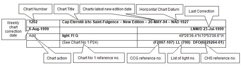
The last correction number is identified with the LNM/D or Last Notice to Mariners Number / Date. This number is expressed in either old notice number format (ex.: 594/99) or in day-month-year format which is the date known as the weekly chart correction date shown in the above diagram as item (8).
MONTHLY EDITION OF NOTICES TO MARINERS
WEB ACCESS
We are offering a feature where subscribers to our on-line service are able to receive the complete electronic monthly edition of
our Notices to Mariners. We are encouraging our clients to visit the web site to subscribe for this service:
http://www.notmar.gc.ca/subscribe/
Users wishing to receive information updates for their charts can do so by setting up a ’User Profile’ on the following web page http://www.notmar.gc.ca/search/mycharts-eng.php?czoxOToibnRtPXN0ZXBfb25lJmxhbmc9ZSI7
This feature permits users to register the nautical charts they currently have in their possession. Registrants are then automatically notified by e-mail when a Notice to Mariners is published concerning these charts.
ADVISORY
NOTICES TO SHIPPING (WRITTEN AND BROADCAST)
The Canadian Coast Guard is implementing a number of changes to the aids to navigation system in Canada.
These changes are advertised as Notices to Shipping (Broadcast and Written) by the Canadian Coast Guard and are followed up with Notices to Mariners, then charts are updated by hand correction, reprints or new editions.
Mariners are advised that all relevant Written Notices to Shipping should be kept until superseded by Notices to Mariners or through revised charts issued by the Canadian Hydrographic Service.
Written Notices to Shipping are available on the Canadian Coast Guard Website at: www.ccg-gcc.gc.ca/eng/CCG/NOTSHIP.
The Canadian Hydrographic Service is reviewing the impact of these changes with the Canadian Coast Guard and together we are preparing an action plan on the issuing of chart revisions.
For further information contact your local Regional Notices to Shipping (NOTSHIP) issuing authorities.
|
Newfoundland *Fisheries and Oceans Canada Canadian Coast Guard Port aux Basques MCTS Centre 49 Stadium Road P.O. Box 99 PORT AUX BASQUES, NL A0M 1C0 Telephone : (709) 695-2168 Facsimile : (709) 695-7784 Email :notshippax@dfo-mpo.gc.ca Website: www.ccg-gcc.gc.ca/e30407 |
Maritimes *Fisheries and Oceans Canada Canadian Coast Guard Sydney MCTS Centre 1190 Westmount Road SYDNEY, N.S, B1R 2J6 Telephone: (902) 564-7751 or 1-800-686-8676 Facsimile: (902) 564-2446 Email :notshipssyd@mar.dfo-mpo.gc.ca Website: www.ccg-gcc.gc.ca/e30406 |
|
Quèbec *Fisheries and Oceans Canada Canadian Coast Guard Les Escoumins MCTS Centre 5 Otis street, LES ESCOUMINS, QC G0T 1K0 Telephone: (418) 233-2308 Facsimile: (418) 233-3299 Email :Opsavis@dfo-mpo.gc.ca Websites :www.marinfo.gc.ca; www.marinfo.gc.ca/en/avisecrits/index.asp; http://www.ccg-gcc.gc.ca/eng/CCG/Notship-Home |
Central & Arctic *Fisheries and Oceans Canada Canadian Coast Guard Marine Communications and Traffic Services Notices to Shipping Series "C" 401 King Street West PRESCOTT, ON K0E 1T0 Telephone (613) 925-0666 or 1-800 265 0237 Facsimile: (613) 925-4519 Email :NotshipC&A@DFO-MPO.GC.CA Website: www.ccg-gcc.gc.ca/eng/CCG/Notship-Home *Fisheries and Oceans Canada Canadian Coast Guard Iqaluit MCTS Centre Notices to Shipping Series "A" and Series “H” P.O. Box 189 IQALUIT NU X0A 0H0 Telephone: (867) 979-5269 Facsimile: (867) 979-4264 Email :IQANORDREG@INNAV.GC.CA Website: www.ccg-gcc.gc.ca/eng/CCG/Notship-Home |
* Services provided in English and French
INDEX
| CANADIAN HYDROGRAPHIC SERVICE - ANNOUNCEMENT REGARDING CANADIAN HYDROGRAPHIC SERVICE CHART PATCHES | 1 |
| CANADIAN HYDROGRAPHIC SERVICE - CUMULATIVE CHART CORRECTIONS | 1 |
| CANADIAN HYDROGRAPHIC SERVICE - CURRENT CHART EDITION DATES | 1 |
| CANADIAN HYDROGRAPHIC SERVICE - PRINT ON DEMAND CHARTS - CARE AND USE | 1 |
| CANADIAN HYDROGRAPHIC SERVICE - TRANSPORT CANADA NAVIGATION SAFETY – ECDIS | 2 |
| UPDATE TO CONSOLIDATION OF MARINE COMMUNICATIONS AND TRAFFIC SERVICES (MCTS) CENTRES | 2 |
| SAGUENAY-ST. LAWRENCE MARINE PARK AND SURROUNDING WATERS - WHALE PROTECTION | 2 |
| CANADIAN COAST GUARD PUBLICATION - RADIO AIDS TO MARINE NAVIGATION (ATLANTIC, ST. LAWRENCE, GREAT LAKES, LAKE WINNIPEG AND EASTERN ARCTIC) PUBLICATION – 2014 - THE COMMERCIAL PUBLIC CORRESPONDENCE SERVICE | 4 |
| TRANSPORT CANADA - RESTRICTED SPEED AREA - ST. CLAIR AND DETROIT RIVER. | 4 |
| *601 SERVICE HYDROGRAPHIQUE DU CANADA - CARTES MARINES | 4 |
| *602 SERVICE HYDROGRAPHIQUE DU CANADA - CARTES ÉLECTRONIQUES DE NAVIGATION | 4 |
| *603(P) CARAQUET HARBOUR, BAIE DE SHIPPEGAN AND/ET MISCOU HARBOUR – AIDS TO BE CHANGED | 5 |
| *604 TRANSPORT CANADA - SHIP SAFETY BULLETIN | 6 |
| *605 TRANSPORT CANADA – SHIP SAFETY BULLETIN | 6 |
| *606 ENTRÉ À/ENTRANCE TO MIRAMICHI RIVER – RANGE DISCOUNTINUED. | 6 |
| *607 PORT SEVERN TO/À PARRY SOUND – BUOY RELOCATED AND AID CODE CHANGED. | 6 |
| *608 PAPINEAUVILLE À/TO OTTAWA – RELOCATED BUOY. | 6 |
| *609(P) MUSQUODOBOIT HARBOUR - AIDS TO BE CHANGED. | 7 |
| *610(P) TAYLORS HEAD TO/À SHUT-IN ISLAND - BELL TO BE REMOVED | 7 |
| *611(P) MIRAMICHI – RANGE TO BE DISCONTINUED. | 8 |
| *612(P) PORT ELGIN/BAIE VERTE – BUOY TO BE DISCONTINUED. | 8 |
| *613 ANNUAL EDITON NOTICES TO MARINERS 1 TO 46. UPDATE TO SECTION C. | 9 |
| *614 RADIO AIDS TO MARINE NAVIGATION 2015, (ATLANTIC, ST. LAWRENCE, GREAT LAKES, LAKE WINNIPEG AND ARCTIC) | 25 |
| NUMERICAL INDEX OF CANADIAN CHARTS AFFECTED. | |||||
| 1230 | 10 | 4025 | 15 | 4617 | 20 |
| 1236 | 10 | 4026 | 15 | 4825 | 21 |
| 1312 | 10 | 4117 | 15, 16 | 4855 | 21 |
| 1313 | 11, 12 | 4230 | 16 | 4858 | 21 |
| 1320 | 12 | 4235 | 16 | 4905 | 21 |
| 1509 | 12 | 4236 | 7 | 4911 | 6, 22 |
| 1514 | 12, 13 | 4237 | 16, 17 | 4912 | 8 |
| 1515 | 6 | 4241 | 17 | 4913 | 5 |
| 2029 | 13 | 4242 | 17 | 4921 | 22 |
| 2058 | 13 | 4277 | 17 | 5001 | 22 |
| 2120 | 13 | 4279 | 17, 18 | 6427 | 4 |
| 2202 | 6, 13 | 4308 | 18 | 7083 | 22 |
| 2228 | 13 | 4335 | 18 | 7121 | 22, 23 |
| 2243 | 13, 14 | 4377 | 18 | 7122 | 23 |
| 4000 | 14 | 4385 | 18 | 7736 | 23 |
| 4001 | 14 | 4406 | 9, 19 | 8006 | 23 |
| 4006 | 14 | 4429 | 19 | 8014 | 23 |
| 4012 | 15 | 4432 | 19 | 8015 | 23 |
| 4017 | 15 | 4440 | 19, 20 | 8049 | 24 |
| 4023 | 15 | 4530 | 20 | ||
SECTION 1
SAFETY AND GENERAL INFORMATION
CANADIAN HYDROGRAPHIC SERVICE - ANNOUNCEMENT REGARDING CANADIAN HYDROGRAPHIC SERVICE CHART PATCHES
Colour Web Patches are free to the mariner, and given the quality of many printers, should reproduce well. They will be available in real time all around the world.
CHS welcomes your feedback on this service at chsinfo@dfo-mpo.gc.ca .
CANADIAN HYDROGRAPHIC SERVICE - CUMULATIVE CHART CORRECTIONS
The cumulative Notices to Mariners corrections for charts can now be accessed at
www.notmar.gc.ca/search/notmar-eng.php .
CANADIAN HYDROGRAPHIC SERVICE - Current chart edition dates
CHART EDITIONS
The three terms described below are used to indicate the publication status of Canadian charts.
NEW CHART - "NEWCHT"
The first publication of a Canadian chart embracing an area not previously charted to the scale shown, or embracing an area different from any existing Canadian chart.
NEW EDITION - "NEWEDT"
A new issue of an existing chart containing amendments essential to navigation in addition to those issued in Notices to Mariners and making existing editions obsolete.
REPRINTS
A new issue of the current edition of a chart incorporating no amendments of navigational significance other than those
previously promulgated in Notices to Mariners. It may also contain amendments from other sources provided they
are not essential to navigation. Previous printings of the current edition remain in force.
The current chart edition dates can be accessed at
www.chs-shc.gc.ca/charts-cartes/paper-papier/index-eng.asp
CANADIAN HYDROGRAPHIC SERVICE - PRINT ON DEMAND CHARTS - CARE AND USE
Background
By providing nautical charts to the public, the goal of the Canadian Hydrographic Service (CHS) is to provide services for safe navigation in a fiscally responsible manner. As a result, CHS continues to expand its portfolio of nautical paper charts that are printed using Print On Demand (POD) technology. These charts are easily recognized by their whiter paper and the coloured logo of the Canadian Hydrographic Service. This new technology enables CHS to print charts in a more efficient manner while enhancing chart content through being able to quickly add new and important information. POD technology provides customers with up-to-date charts without the historical hand-drawn corrections or glued-on patches. Additionally, this technology eliminates out-of-stock situations which arise with the traditional printing and warehousing methods. In the event of a national emergency, CHS can respond to the appropriate authorities with best available information very quickly.
Care of Your POD Chart
CHS encourages its customers to handle the POD charts more carefully than the traditional lithographic charts. When plotting information on POD charts, use HB pencils and apply limited pressure. Testing has suggested that an Indian gum eraser is more effective than alternatives when used on the product. This eraser is also suitable for charts printed using lithographic processes.
CANADIAN HYDROGRAPHIC SERVICE - TRANSPORT CANADA NAVIGATION SAFETY - ECDIS
Mariners are advised that ECDIS may not display some isolated shoal depths when operating in "base or standard display" mode. Route planning and monitoring alarms for these shoal depths may not always be activated. To ensure safe navigation and to confirm that a planned route is clear of such dangers, mariners should visually inspect the planned route and any deviations from it using ECDIS configured to display "all data". The automated voyage planning check function should not be solely relied upon.
UPDATE TO CONSOLIDATION OF MARINE COMMUNICATIONS AND TRAFFIC SERVICES (MCTS) CENTRES
The Canadian Coast Guard is modernizing and consolidating its Marine Communications and Traffic
Services Centres. Clients will continue to receive the high-quality service they have come to expect.
Once complete, there will be a total of 12 MCTS Centres strategically located across the country. Additional
information pertaining to this project will be advertised to clients by all available means
Atlantic Region
Saint John (Fundy) MCTS Centre will consolidate to Halifax MCTS Centre commencing March 2015
St. John’s MCTS Centre will consolidate to Placentia MCTS Centre commencing March 2015
St. Anthony MCTS Centre will consolidate to Labrador (Goose Bay) MCTS Centre commencing August 2015
Central & Arctic Region
Thunder Bay MCTS Centre will consolidate to Sarnia MCTS Centre commencing May 2015.
Rivière-au-Renard MCTS centre will consolidate to Les Escoumins MCTS centre commencing June 2015.
The new technology will increase efficiency permitting employees to have a greater ability to focus on the safety
services they provide to mariners. Mariners are encouraged to visit the Radio Aids to Marine Navigation (RAMN)
http://www.ccg-gcc.gc.ca/Marine-Communications/Home
and Notices to Mariners (NOTMAR) http://www.notmar.gc.ca/ PART 3 on a
monthly basis for updated information and potential changes to contact information and marine broadcast schedules.
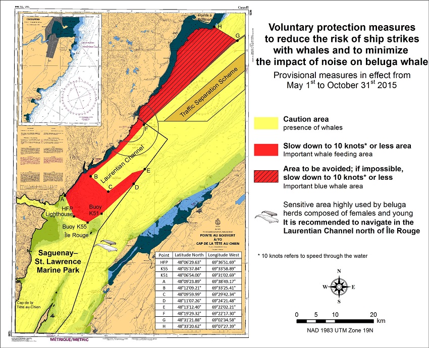
SAGUENAY-ST. LAWRENCE MARINE PARK AND SURROUNDING WATERS - WHALE PROTECTION.
The waters in and around the Saguenay-St. Lawrence Marine Park are well known for their resident threatened beluga population and the wide diversity of whales that migrate there to feed, particularly between April and November.
REGULATORY PROTECTION MEASURES
All whale species that are found in the St. Lawrence are protected under the Marine Mammal Regulations, pursuant to the Fisheries Act. Within the boundaries of the Marine Park, specific measures are set out in the Marine Activities in the Saguenay–St. Lawrence Marine Park Regulations, pursuant to the Act Establishing the Saguenay-St. Lawrence Marine Park. Any collision with a marine mammal within the Marine Park must immediately be reported to a park warden at 1-866-508-9888. For collisions that occur outside the Marine Park or for any situation involving a marine mammal that is dead or in trouble, contact the emergency network at 1-877-722-5346 or on channel 16.
For more information on the Saguenay-St. Lawrence Marine Park, see section 5C of the Annual Edition of the Notices to Mariners – April 2015 to March 2016.
VOLUNTARY PROTECTION MEASURES
Provisional measures in effect from May 1st to October 31st, 2015. See map below.
These measures apply to merchant vessels and cruise ships between Pointe à Boisvert and Cap de la Tête au Chien to prevent collisions with whales. These measures should only be taken when they will not jeopardize navigational safety.
Caution area (yellow area) : To reduce the risk of collisions with whales that can be present anywhere in this area, heightened vigilance of navigators is critical. Posting a lookout is recommended in order to increase the chances of seeing the whales and thus taking necessary measures to avoid them. If bypassing the whales is not possible, slow down and wait for the animals to move away to a distance greater than 400 meters (0.215 nautical miles) before resuming original speed. It is more difficult to see the animals at night therefore increased caution is recommended.
Slow down to 10 knots or less area (red area) : To reduce the risk of collisions with whales in this feeding area, it is recommended that vessels slow down to a maximum speed through the water of 10 knots and post a lookout. It is further recommended to remain in the Laurentian Channel to the north of Île Rouge to minimize the impact of noise in a sensitive area south of this island, which is highly frequented by herds of beluga whales composed of females and young.
Area to be avoided (hatched red area) : To reduce noise and the risk of collisions with whales, vessels should avoid transiting through this area which is highly frequented by blue whales, an endangered species. If the area cannot be avoided, slow down to a speed through the water of 10 knots or less.
CANADIAN COAST GUARD PUBLICATION - RADIO AIDS TO MARINE NAVIGATION (ATLANTIC, ST. LAWRENCE, GREAT LAKES, LAKE WINNIPEG AND EASTERN ARCTIC) PUBLICATION - 2013 - The Commercial Public Correspondence Service.
Part I - Page 1 of 10
ADVANCE NOTICES
The Commercial Public Correspondence Service
Effective January 1, 2014, the following changes to the Canadian Coast Guard commercial public correspondence service, provided through select Marine Communications and Traffic Services centres, will be in effect: All long distance ship-shore calls will be administered through the regular telephone service provider as acollect call. Individuals intending to placeshore-ship calls will be required to direct-dial the appropriate MCTS centre. MCTS centres providing a commercial public correspondence service are identified in RAMN, Part 2.
*601 CANADIAN HYDROGRAPHIC SERVICE - NAUTICAL CHARTS.
| CHARTS | MAIN TITLE | SCALE | PUBLISHED | CAT# | PRICE |
| New Editions | |||||
| 6427 | Point Separation to/au Aklavik Channel Kilometre 1480 / Kilometre 1540 | 1:50000 | 30-JAN-2015 | 4 | 12.00 |
*602 CANADIAN HYDROGRAPHIC SERVICE - ELECTRONIC NAVIGATIONAL CHART
| NEW PRODUCTS | |
| S-57 ENC NUMBER | CHART TITLE |
| CA576723 | Escuminac |
*603(P) CARAQUET HARBOUR, BAIE DE SHIPPEGAN AND/ET MISCOU HARBOUR - AIDS TO BE CHANGED.
Reference chart: 4913
The Canadian Coast Guard proposes the following permanent changes:
| Floating Aids | ||
| List of Lights Number | Name | Proposed Change(s) |
| 6262.423 EAA |
Fox Dens Gully Conical Plastic Buoy |
Positioned at 47 53 5.28N 064 30 29.82W. Flash characteristics 2cd w/White (Q)1s. |
| New Establishment EAB |
New Establishment | A new lit buoy, 2cd, with a white (Q(6)+LFI) 15s flash to be established at 47 53 5.52N 064 30 31.38W. |
| New Establishment EA41 |
New Establishment | A new unlit buoy to be established at 47 53 2.82N 064 30 36.06W. |
| New Establishment EA40 |
New Establishment | New lit buoy, positioned at 47 53 0.66N 064 30 37.14W. |
| 6272.3 EA39 |
Miscou Harbour Plastic Can Buoy |
Change flash characteristics to Green Q Fl 1s 2cd, and relocate buoy to 47 52 57.06 064 30 50.16W. |
| Nouvelle bouée non lumineuse EA38 |
New Establishment | A new unlit buoy to be established at 47 52 57.06N 064 30 50.16W. |
| 6272.29 EA37 |
Miscou Harbour Plastic Can Buoy |
Relocate buoy to 47 52 57.18N 064 30 59.46W, and change flash characteristics to green Fl 4s,2cd. |
| New Establishment EA36 |
New Establishment | A new lit buoy to be positioned at 47 52 56.4N / 064 30 58.68W. |
| 6272.28 EA35 |
Miscou Harbour Plastic Can Buoy |
Relocate buoy to 47 52 55.2N 064 31 12.42W. |
| Nouvelle bouée non lumineuse EA32 |
New Establishment | A new unlit buoy to be established at 47 52 52.68N 064 31 24.48W. |
| 1272.10 EA30 |
Bouée de Miscou Harbour | Repositionner à 47 52 50.76N 064 31 37.14W Changer les caractéristiques du feu pour Fl 1s., 2cd. |
| 6272.26 EA31 |
Miscou Harbour Bouée cylindrique en plastique |
Ajouter feu Green Fl 4s, et min. 2cd. Repositionner à 47 52 51.54N 064 31 37.44W. |
Comments on this action are solicited from mariners and other interested parties.
Comments should be directed to
Superintendent, Aids to Navigation,
Aides à la navigation et Voies navigables,
Canadian Coast Guard by
PO Box 1236,
Charlottetown, Prince Edward Island, C1A 7M8
Telephone: 902-566-7936,
Email : claire.maclaren@dfo-mpo.gc.ca
Any objections raised must state the facts on which they are based and should include supporting information on safety, commerce and public benefit within three months from the date of this Notice.
(G2015-047)
*604 TRANSPORT CANADA - SHIP SAFETY BULLETIN.
This is to notify you that a new Ship Safety Bulletin has recently been posted to the Transport Canada website at
www.tc.gc.ca/bsn-ssb/.
To go online to view or download the bulletin, please click on the links below:
SSB #06/2015- Safety of Dead Ship Towing Operations - RDIMS#10506677.
Note: Sign yourself up for e-Bulletin to receive an e-mail notice each time a new Ship Safety Bulletin is published on our Website.
pour recevoir un avis par courriel chaque fois qu'un nouveau Bulletin de la sécurité des navires est publié sur notre site Web.
Contact us at : securitemaritime-marinesafety@tc.gc.caor 1-855-859-3123 (Toll free)
*605 TRANSPORT CANADA - SHIP SAFETY BULLETIN.
This is to notify you that a new Ship Safety Bulletin has recently been posted to the Transport Canada website at
www.tc.gc.ca/bsn-ssb/.
To go online to view or download the bulletin, please click on the links below:
SSB #03/2015- Sheltered waters voyages (amendment 2015-05-29) - RDIMS#10385708.
Note: Sign yourself up for e-Bulletin to receive an e-mail notice each time a new Ship Safety Bulletin is published on our Website.
pour recevoir un avis par courriel chaque fois qu'un nouveau Bulletin de la sécurité des navires est publié sur notre site Web.
Contact us at : securitemaritime-marinesafety@tc.gc.caor 1-855-859-3123 (Toll free)
*606 ENTRÉ À/ENTRANCE TO MIRAMICHI RIVER – RANGE DISCOUNTINUED.
Reference: Notice 707(P)/2014 LL 1173.15 and LL1173.16 is now cancelled. (Chart 4911)
(G2015-030-031)
*607 PORT SEVERN TO/À PARRY SOUND – BUOY RELOCATED AND AID CODE CHANGED.
Reference Chart: 2202
The Canadian Coast Guard have permanently changed the aid code and relocated the following aid :
Georgian Bay-port Severn Bridge LL 8047.9
New aid code C9
new position 44 47’ 57.24
079 43’ 23.76
(D2015-001)
*608 PAPINEAUVILLE À/TO OTTAWA – RELOCATED BUOY.
Reference Chart: 1515
The Canadian Coast Guard proposes to permanently discontinue the following Aid to navigation:
Parc national 2, LL 11981.0 (45° 35’35.1’’N 075°05’ 01.7’’W)
(Q2015-054)
*609(P) MUSQUODOBOIT HARBOUR - AIDS TO BE CHANGED.
Reference Chart: 4236
The Canadian Coast Guard proposes to make the following permanent changes to the aids to navigation in the Musquodoboit Harbour area:
• LLNO 5566.01 YV5 – Discontinue
• LLNO 5566.02 YV7 - Add green lantern, Fl 4s, change LLNO 566.02
• LLNO 5566.03 YV10 - Add Red lantern, quick flash, change LLNO 566.03, reposition to 44 41.16N 063 04.775W
• LLNO 5566.04 YV11 – Add green lantern, Fl 4s, change LLNO 566.04, reposition to 44 41.437N 063 04.792W
• LLNO 5566.05 YV12 – Add red lantern, Fl 4s, change LLNO 566.05, reposition to 44 41.437N 063 04.714W
• LLNO 5566.06 YV13 – Add green lantern, Fl 4s, change LLNO 566.06, reposition to 44 41.567N 063 04.729W
• LLNO 5566.07 YV14 – Discontinue
• LLNO 5566.08 YV15 – Add green lantern, quick flash, change LLNO 566.08, reposition to 44 41.685N 063 04.745W
• LLNO 5566.09 YV16 – reposition to 44 41.823N 063 04.750W
• LLNO 5566.10 YV17 – reposition to 44 42.07N 064 04.904W
• LLNO 5566.11 YV18 – add red lantern, quick flash, change LLNO 566.11, reposition to 44 42.52N 063 04.95W
• LLNO 5566.13 YV22- Discontinue (replaced by YV20)
• LLNO 5566.115 YV20 - rename to Musquodoboit (NE Francis Nose Is.) Spar Buoy YV20, reposition to
44 42.962N 063 05.052W (YV22 position)
• LLNO 5566.12 YV21 – add green lantern with quick flash
Comments on this action are solicited from mariners and other interested parties within three month from the date of this Notice.
Comments should be directed to:
Superintendent,Aids to Navigation
Canadian Coast Guard,
PO Box 5667,
St. John’s, NL, A1C 5X1
Telephone: 709-772-5195
Email: claire.maclaren@dfo-mpo.gc.ca.
Any objections raised must state the facts on which they are based and should include supporting information on safety, commerce and public benefit.
(F2015-19)
*610(P) TAYLORS HEAD TO/À SHUT-IN ISLAND - BELL TO BE REMOVED
Reference Chart: 4236
The Canadian Coast Guard proposes to permanently discontinue the following Aid to navigation:
Musquodoboit Ledge light and Bell Buoy YV3 – Sound to be removed (Bell), LL 566.5 (44°39’36.0’’N 63° 04’16.0’’W).
Comments on this action are solicited from mariners and other interested parties.
Comments should be directed to the following within three months from the date of this notice:
Superintendent, Aids to Navigation
Canadian Coast Guard,
P.O. Box 5667, St. John’s, NL, A1C 5X1
Telephone: 709-772-5195
Email: claire.maclaren@dfo-mpo.gc.ca.
Any objections raised must state the facts on which they are based and should include supporting information on safety, commerce and public benefit.
(F2015-018)
*611(P) MIRAMICHI – RANGE TO BE DISCONTINUED.
Reference Chart: 4912
The Canadian Coast Guard proposes to permanently discontinue the following Aid to navigation:
Newcastle range, front LL 1218 (47°00’ 57,9’’N 065° 32’ 44.1W)
Rear LL 1219 (47°00’58.1’’N 065° 32’46.4’’W)
Comments on this action are solicited from mariners and other interested parties.
Comments should be directed to the following within three months from the date of this notice:
Superintendent, Aids to Navigation & Waterways,
Canadian Coast Guard,
PO Box 1236,
Charlottetown, Prince Edward Island, C1A 7M8
Telephone: 709-772-5195
Email: claire.maclaren@dfo-mpo.gc.ca.
Any objections raised must state the facts on which they are based and should include supporting information on safety, commerce and public benefit.
(G2015-032)
(G2015-034)
*612(P) PORT ELGIN/BAIE VERTE – BUOY TO BE DISCONTINUED.
The Canadian Coast Guard proposes to permanently discontinue the following buoys:
PLAS10 - 6094.54 - Port Elgin - Baie Verte can plastic buoy
6094.53 - Port Elgin - Baie Verte can plastic buoy
6094.52 - Port Elgin - Baie Verte can plastic buoy
6094.51 - Port Elgin - Baie Verte can plastic buoy
6094.50 - Port Elgin - Baie Verte can plastic buoy
6094.49 - Port Elgin - Baie Verte can plastic buoy
6094.48 - Port Elgin - Baie Verte can plastic buoy
6094.47 - Port Elgin - Baie Verte can plastic buoy
6094.46 - Port Elgin - Baie Verte can plastic buoy
6094.31 - Port Elgin - Baie Verte can plastic buoy
PLAS15 - 6094.30 - Port Elgin - Baie Verte can plastic buoy
6094.45 - Port Elgin - Baie Verte can plastic buoy
6094.44 - Port Elgin - Baie Verte can plastic buoy
6094.43 - Port Elgin - Baie Verte can plastic buoy
6094.42 - Port Elgin - Baie Verte can plastic buoy
6094.41 - Port Elgin - Baie Verte can plastic buoy
6094.40 - Port Elgin - Baie Verte can plastic buoy
6094.39 - Port Elgin - Baie Verte can plastic buoy
6094.38 - Port Elgin - Baie Verte can plastic buoy
6094.37 - Port Elgin - Baie Verte can plastic buoy
6094.36 - Port Elgin - Baie Verte can plastic buoy
6094.35 - Port Elgin - Baie Verte can plastic buoy
6094.34 - Port Elgin - Baie Verte can plastic buoy
6094.33 - Port Elgin - Baie Verte can plastic buoy
6094.32 - Port Elgin - Baie Verte can plastic buoy
PLAS - 6094.20 - Port Elgin - Baie Verte conical plastic buoy – 46° 3’ 6”N 64° 4’ 6”W - Uncharted
XC2 - 6094.10 - Port Elgin Conical XC2 – 46° 2’ 5.1”N 64° 2’ 38.9”W – Chart 4406
Comments on this action are solicited from mariners and other interested parties.
Comments should be directed to the following within three months from the date of this notice:
Superintendent, Aids to Navigation
Canadian Coast Guard,
PO Box 1236,
Charlottetown, Prince Edward Island, C1A 7M8
Telephone: 902-566-7936
Email: claire.maclaren@dfo-mpo.gc.ca.
Any objections raised must state the facts on which they are based and should include supporting information on safety, commerce and public benefit.
*613 ANNUAL EDITON NOTICES TO MARINERS 1 TO 46. UPDATE TO SECTION C.
Reference to Notice to Mariners 27A.
GUIDELINES FOR THE TRANSIT OF WIDE BEAM VESSELS AND LONG VESSELS.
AMEND:
2) Directives concerning the meeting of vessels in medium- and high-risk areas (R)
R-1) Meetings are prohibited in high-risk areas. The high-risk areas between Québec and Montréal for vessels with a
combined nominal breadth of between 65 and 72.6 metres and between 72.61 metres and 88 metres are identified on chart VN-301.
TO READ:
2) Directives concerning the meeting of vessels in medium- and high-risk areas (R)
Any time, wide beam vessels have to favor day transit in the section Quebec-Montreal.
R-1) Meetings are prohibited in high-risk areas. The high-risk areas between Québec and Montréal for vessels with a
combined nominal breadth of between 65 and 72.6 metres and between 72.61 metres and 88 metres are identified on chart VN-301.
AMEND:
3) Directives on overtaking in medium- and high-risk (D)
D-1) Overtaking is prohibited in high-risk areas. The high-risk areas between Québec and Montréal for vessels with a
combined nominal breadth of between 65 metres and 72.6 metres and between 72.61 metres and 88 metres are identified on chart VN-301.
TO READ:
3) Directives on overtaking in medium- and high-risk (D)
Any time, wide beam vessels will have to favor day transit in the section Quebec-Montreal.
D-1) Overtaking is prohibited in high-risk areas. The high-risk areas between Québec and Montréal for vessels with a
combined nominal breadth of between 65 metres and 72.6 metres and between 72.61 metres and 88 metres are identified on chart VN-301.
CHART CORRECTIONS
| 1230 - Rivière-au-Renard - New Edition - 19-FEB-2010 - NAD 1983 | |||
| 05-JUN-2015 | LNM/D. 09-JAN-2015 | ||
| Delete | depth of 0 metre 3 decimetres (See Chart No. 1, I10) This notice affects Electronic Navigational Chart: CA579167 |
48°59′55.8″N 064°23′28.4″W | |
| DFO(6409105-01) | |||
| Add | drying height of 0 metres 1 decimetre (See Chart No. 1, I15) This notice affects Electronic Navigational Chart: CA579167 |
48°59′56.0″N 064°23′28.7″W | |
| DFO(6409105-02) | |||
| Add | depth of 0 metre 2 decimetres (See Chart No. 1, I10) This notice affects Electronic Navigational Chart: CA579167 |
48°59′55.4″N 064°23′27.8″W | |
| DFO(6409105-03) | |||
| Delete | depth of 0 metre 8 decimetres (See Chart No. 1, I10) This notice affects Electronic Navigational Chart: CA579167 |
48°59′54.4″N 064°23′28.0″W | |
| DFO(6409105-04) | |||
| Add | depth of 0 metre 6 decimetres (See Chart No. 1, I10) This notice affects Electronic Navigational Chart: CA579167 |
48°59′54.0″N 064°23′28.5″W | |
| DFO(6409105-05) | |||
| Amend | Fl G 5s19M to read Fl G 5s8m19M against light (See Chart No. 1, P16) This notice affects Electronic Navigational Chart: CA279044, CA579167 |
48°59′52.4″N 064°22′59.9″W | |
| (Q2015044) LL(1629) DFO(6409106-01) | |||
| 1236 - Pointe des Monts aux/to Escoumins - New Edition - 26-OCT-2012 - NAD 1983 | |||
| 12-JUN-2015 | LNM/D. 27-MAR-2015 | ||
| Replace | depth of 135 metres with depth of 128 metres (See Chart No. 1, I10) |
49°20′08.0″N 067°13′36.9″W | |
| DFO(6409120-01) | |||
| 1312 - Lac Saint-Pierre - New Edition - 24-MAY-2013 - NAD 1983 | |||
| 12-JUN-2015 | LNM/D. 15-MAY-2015 | ||
| Amend | F G 28m15M to read F G 29m15M against light (See Chart No. 1, P16) This notice affects Electronic Navigational Chart: CA479129 |
46°15′32.7″N 072°37′21.4″W | |
| (Q2015045) LL(2118) DFO(6409107-01) | |||
| Amend | F G 8m15M to read F G 10m15M against light (See Chart No. 1, P16) This notice affects Electronic Navigational Chart: CA479129 |
46°15′34.9″N 072°37′48.4″W | |
| (Q2015046) LL(2117) DFO(6409108-01) | |||
| 1313 - Batiscan au/to Lac Saint-Pierre - New Edition - 07-JUN-2013 - NAD 1983 | |||
| 12-JUN-2015 | LNM/D. 05-JUN-2015 | ||
| Amend | F G 28m15M to read F G 29m15M against light (See Chart No. 1, P16) This notice affects Electronic Navigational Chart: CA479129 |
46°15′32.7″N 072°37′21.4″W | |
| (Q2015045) LL(2118) DFO(6409107-01) | |||
| Amend | F G 8m15M to read F G 10m15M against light (See Chart No. 1, P16) This notice affects Electronic Navigational Chart: CA479129 |
46°15′34.9″N 072°37′48.4″W | |
| (Q2015046) LL(2117) DFO(6409108-01) | |||
| 05-JUN-2015 | LNM/D. 15-MAY-2015 | ||
| Add | depth of 8 metres 8 decimetres (See Chart No. 1, I10) This notice affects Electronic Navigational Chart: CA479014 |
46°22′56.2″N 072°25′46.7″W | |
| DFO(6409121-01) | |||
| Add | depth of 4 metres 9 decimetres (See Chart No. 1, I10) This notice affects Electronic Navigational Chart: CA479014 |
46°26′17.2″N 072°19′59.6″W | |
| DFO(6409121-02) | |||
| Add | depth of 6 metres 4 decimetres (See Chart No. 1, I10) This notice affects Electronic Navigational Chart: CA479014 |
46°26′29.0″N 072°17′12.1″W | |
| DFO(6409121-03) | |||
| 1313 - Port de Trois-Rivières - New Edition - 07-JUN-2013 - NAD 1983 | |||
| 05-JUN-2015 | LNM/D. 15-MAY-2015 | ||
| Delete | depth of 7 metres 6 decimetres (See Chart No. 1, I10) This notice affects Electronic Navigational Chart: CA579015 |
46°20′45.5″N 072°31′47.6″W | |
| DFO(6409039-01) | |||
| Add | depth of 7 metres 2 decimetres (See Chart No. 1, I10) This notice affects Electronic Navigational Chart: CA579015 |
46°20′45.8″N 072°31′47.1″W | |
| DFO(6409039-02) | |||
| Delete | depth of 7 decimetres 4 decimetres (See Chart No. 1, I10) This notice affects Electronic Navigational Chart: CA579015 |
46°20′43.1″N 072°31′51.2″W | |
| DFO(6409039-03) | |||
| Add | depth of 6 metres 9 decimetres (See Chart No. 1, I10) This notice affects Electronic Navigational Chart: CA579015 |
46°20′43.1″N 072°31′51.5″W | |
| DFO(6409039-04) | |||
| Delete | depth of 8 metres 8 decimetres (See Chart No. 1, I10) This notice affects Electronic Navigational Chart: CA579015 |
46°20′41.3″N 072°31′54.2″W | |
| DFO(6409039-05) | |||
| Add | depth of 8 metres 4 decimetres (See Chart No. 1, I10) This notice affects Electronic Navigational Chart: CA579015 |
46°20′41.3″N 072°31′53.3″W | |
| DFO(6409039-06) | |||
| Delete | depth of 9 metres 3 decimetres (See Chart No. 1, I10) This notice affects Electronic Navigational Chart: CA579015 |
46°20′35.8″N 072°32′02.6″W | |
| DFO(6409039-07) | |||
| Add | depth of 9 metres 0 decimetre (See Chart No. 1, I10) This notice affects Electronic Navigational Chart: CA579015 |
46°20′35.8″N 072°32′03.2″W | |
| DFO(6409039-08) | |||
| Amend | 10,4m (2013) to read 10,1m (2014) (See Chart No. 1, I22) This notice affects Electronic Navigational Chart: CA579015 |
46°20′03.0″N 072°32′33.3″W | |
| DFO(6409039-09) | |||
| 1320 - Port de Gros-Cacouna - New Chart - 26-AUG-2011 - NAD 1983 | |||
| 26-JUN-2015 | LNM/D. 16-JAN-2015 | ||
| Affix | patch Download patch - http://www.chs-shc.gc.ca/patches/pa1320-20150527.pdf This notice affects Electronic Navigational Chart: CA579234 |
47°55′50.0″N 069°30′58.0″W | |
| DFO(6409127-01) | |||
| 1509 - Rapides du Cheval Blanc - Sheet/Feuille 1 - New Edition - 19-APR-2013 - NAD 1983 | |||
| 05-JUN-2015 | LNM/D. 20-MAR-2015 | ||
| Amend | 45°27′36.00″N to read 45°30′36.00″N (See Chart No. 1, A10) |
left side of south border | |
| DFO(6409023-01) | |||
| 1514 - Carillon à/to L'Orignal - Sheet/Feuille 1 - New Chart - 24-JUL-1998 - NAD 1983 | |||
| 19-JUN-2015 | LNM/D. 06-MAR-2015 | ||
| Delete | depth of 1 metre 5 decimetres (See Chart No. 1, I10) |
45°37′03.4″N 074°37′16.8″W | |
| DFO(6409124-04) | |||
| Add | obstruction with known depth of 0 metres 1 decimetre (See Chart No. 1, K41) |
45°37′03.4″N 074°37′15.6″W | |
| DFO(6409124-05) | |||
| 1514 - L'Orignal à/to Papineauville - Sheet/Feuille 2 - New Chart - 24-JUL-1998 - NAD 1983 | |||
| 19-JUN-2015 | LNM/D. 06-MAR-2015 | ||
| Add | Stump (See Chart No. 1, K43.2) |
45°37′59.2″N 074°42′58.8″W | |
| DFO(6409124-01) | |||
| Delete | depth of 5 metres 5 decimetres (See Chart No. 1, I10) |
45°38′32.3″N 074°52′12.8″W | |
| DFO(6409124-02) | |||
| Add | obstruction with known depth of 1 metre 0 décimetre (See Chart No. 1, K41) |
45°38′32.4″N 074°52′11.2″W | |
| DFO(6409124-03) | |||
| 2029 - Big Chute to/à Port Severn - Sheet/Feuille 2 - New Edition - 21-DEC-2012 - NAD 1983 | |||
| 05-JUN-2015 | LNM/D. 29-NOV-2013 | ||
| Replace | green port hand spar buoy, marked C9/3 with green port hand spar buoy, marked C9 (See Chart No. 1, QG) |
44°47′57.2″N 079°43′23.8″W | |
| (D2015001) LL(8047.9) DFO(6604096-02) | |||
| 2058 - Cobourg to/à Oshawa - New Edition - 25-FEB-2000 - NAD 1983 | |||
| 19-JUN-2015 | LNM/D. 19-SEP-2014 | ||
| Delete | obstruction, depth unknown,,″Rep (2013)″ (See Chart No. 1, K40, I3.2) This notice affects Electronic Navigational Chart: CA373064 |
43°54′57.0″N 078°17′57.0″W | |
| DFO(6604102-01) | |||
| Add | wreck, least depth unknown, dangerous to surface navigation (See Chart No. 1, K28) This notice affects Electronic Navigational Chart: CA373064 |
43°54′58.3″N 078°17′55.6″W | |
| DFO(6604102-03) | |||
| 2120 - Port Dover - New Edition - 15-APR-2005 - NAD 1983 | |||
| 19-JUN-2015 | LNM/D. 24-OCT-2014 | ||
| Add | depth of 1.5 metres (See Chart No. 1, I10) This notice affects Electronic Navigational Chart: CA573303 |
42°46′50.3″N 080°11′44.5″W | |
| DFO(6604103-03) | |||
| 2202 - Port Severn to/à Tomahawk Island - Sheet/Feuille 1 - New Edition - 05-JAN-2007 - NAD 1983 | |||
| 05-JUN-2015 | LNM/D. 27-SEP-2013 | ||
| Replace | green port hand spar buoy, marked C9/3 with green port hand spar buoy, marked C9 (See Chart No. 1, QG) |
44°47′57.2″N 079°43′23.8″W | |
| (D2015001) LL(8047.9) DFO(6604096-02) | |||
| 2228 - Lake Huron/Lac Huron (Southern Portion/Partie sud) - New Chart - 16-FEB-1990 - NAD 1983 | |||
| 12-JUN-2015 | LNM/D. 16-JAN-2015 | ||
| Amend | chart 2228 or L/C 2228 to read 2228-1 |
located outside of the chart border in the South West and North East corners. |
|
| DFO(6604101-01) | |||
| Amend | ″See inset on back″ to read ″See Inset/voir cartouche on/sur 2228-2″ |
43°43′36.0″N 081°41′48.0″W | |
| DFO(6604101-02) | |||
| 2243 - Bateau Island to/à Byng Inlet - New Edition - 30-AUG-1985 - NAD 1927 | |||
| 12-JUN-2015 | LNM/D. 07-JUN-2013 | ||
| Delete | depth of 7 feet (See Chart No. 1, I10) This notice affects Electronic Navigational Chart: CA373311 |
45°19′52.8″N 080°22′53.0″W | |
| DFO(6604100-01) | |||
| Add | depth of 2 feet (See Chart No. 1, I10) This notice affects Electronic Navigational Chart: CA373311 |
45°19′54.5″N 080°22′52.0″W | |
| DFO(6604100-03) | |||
| 4000 - Gulf of Maine to/à Baffin Bay / Baie de Baffin - New Edition - 25-JUL-2003 - NAD 1983 | |||
| 19-JUN-2015 | LNM/D. 29-MAY-2015 | ||
| Add | subsurface Ocean Data Acquisition system (ODAS) with known depth of 60 metres (See Chart No. 1, L25) This notice affects Electronic Navigational Chart: CA176030 |
51°50′06.0″N 052°30′24.0″W | |
| DFO(6307140-01) | |||
| Add | subsurface Ocean Data Acquisition system (ODAS) with known depth of 45 metres (See Chart No. 1, L25) This notice affects Electronic Navigational Chart: CA176030 |
50°16′42.0″N 051°50′42.0″W | |
| DFO(6307140-02) | |||
| Add | subsurface Ocean Data Acquisition system (ODAS) with known depth of 56 metres (See Chart No. 1, L25) This notice affects Electronic Navigational Chart: CA176030, CA276092 |
48°59′24.0″N 051°02′06.0″W | |
| DFO(6307140-03) | |||
| 4001 - Gulf of Maine to Strait of Belle Isle /au Detroit de Belle Isle - New Edition - 01-DEC-1995 - NAD 1983 | |||
| 19-JUN-2015 | LNM/D. 29-MAY-2015 | ||
| Add | subsurface Ocean Data Acquisition system (ODAS) with known depth of 60 metres (See Chart No. 1, L25) This notice affects Electronic Navigational Chart: CA176030 |
51°50′06.0″N 052°30′24.0″W | |
| DFO(6307140-01) | |||
| Add | subsurface Ocean Data Acquisition system (ODAS) with known depth of 45 metres (See Chart No. 1, L25) This notice affects Electronic Navigational Chart: CA176030 |
50°16′42.0″N 051°50′42.0″W | |
| DFO(6307140-02) | |||
| Add | subsurface Ocean Data Acquisition system (ODAS) with known depth of 56 metres (See Chart No. 1, L25) This notice affects Electronic Navigational Chart: CA176030, CA276092 |
48°59′24.0″N 051°02′06.0″W | |
| DFO(6307140-03) | |||
| 4006 - Newfoundland and Labrador/Terre-Neuve-et-Labrador to Bermuda / aux Bermudes – New Edition - 08-AUG-2003 - NAD 1983 | |||
| 19-JUN-2015 | LNM/D. 29-MAY-2015 | ||
| Add | subsurface Ocean Data Acquisition system (ODAS) with known depth of 60 metres (See Chart No. 1, L25) This notice affects Electronic Navigational Chart: CA176030 |
51°50′06.0″N 052°30′24.0″W | |
| DFO(6307140-01) | |||
| 4012 - Yarmouth to/à Halifax - New Edition - 14-FEB-2003 - NAD 1983 | |||
| 05-JUN-2015 | LNM/D. 29-MAY-2015 | ||
| Amend | FogSig to read FogSig (Occas) (See Chart No. 1, R20) This notice affects Electronic Navigational Chart: CA276800, CA376047 |
43°26′59.0″N 065°28′15.0″W | |
| (F2015014) LL(336) DFO(6307115-01) | |||
| 4017 - Cape Race to/à Cape Freels - New Edition - 07-MAR-2003 - NAD 1983 | |||
| 19-JUN-2015 | LNM/D. 16-JAN-2015 | ||
| Add | subsurface Ocean Data Acquisition system (ODAS) with known depth of 31 fathoms (See Chart No. 1, L25) This notice affects Electronic Navigational Chart: CA176030, CA276092 |
48°59′24.0″N 051°02′06.0″W | |
| DFO(6307140-03) | |||
| 4023 - Northumberland Strait / Détroit de Northumberland - New Edition - 27-DEC-2002 - NAD 1983 | |||
| 19-JUN-2015 | LNM/D. 07-NOV-2014 | ||
| Amend | FlG to read QG against light (See Chart No. 1, P16) This notice affects Electronic Navigational Chart: CA276286, CA376076 |
46°24′20.5″N 064°08′05.9″W | |
| (G2015038) LL(1025.5) DFO(6307141-01) | |||
| 4025 - Cap Whittle à/to Havre-Saint-Pierre et/and Île d'Anticosti - New Edition - 28-MAR-2014 - NAD 1983 | |||
| 12-JUN-2015 | LNM/D. 09-JAN-2015 | ||
| Delete | depth of 121 metres (See Chart No. 1, I10) |
49°19′43.6″N 063°35′36.0″W | |
| DFO(6409120-02) | |||
| Add | depth of 91 metres (See Chart No. 1, I10) |
49°20′05.9″N 063°36′14.4″W | |
| DFO(6409120-03) | |||
| 4026 - Havre Saint-Pierre et/and Cap des Rosiers à/to Pointe des Monts - New Edition - 23-MAY-2014 - NAD 1983 | |||
| 05-JUN-2015 | LNM/D. 27-MAR-2015 | ||
| Amend | Fl G 5s19M to read Fl G 5s8m19M against light (See Chart No. 1, P16) This notice affects Electronic Navigational Chart: CA279044, CA579167 |
48°59′52.4″N 064°22′59.9″W | |
| (Q2015044) LL(1629) DFO(6409106-01) | |||
| 4117 - Saint John Harbour and Approaches / et les approches - New Edition - 29-MAY-2009 - NAD 1983 | |||
| 05-JUN-2015 | LNM/D. 15-MAY-2015 | ||
| Delete | light F (See Chart No. 1, P1) This notice affects Electronic Navigational Chart: CA576005 |
45°16′06.5″N 066°04′28.8″W | |
| DFO(6307125-01) | |||
| Delete | light F (See Chart No. 1, P1) This notice affects Electronic Navigational Chart: CA576005 |
45°16′12.0″N 066°04′29.8″W | |
| DFO(6307125-02) | |||
| Add | light FG (See Chart No. 1, P1) This notice affects Electronic Navigational Chart: CA576005 |
45°16′07.6″N 066°04′28.7″W | |
| DFO(6307125-03) | |||
| Add | light FG (See Chart No. 1, P1) This notice affects Electronic Navigational Chart: CA576005 |
45°16′07.5″N 066°04′29.7″W | |
| DFO(6307125-04) | |||
| Add | light FR (See Chart No. 1, P1) This notice affects Electronic Navigational Chart: CA576005 |
45°16′10.6″N 066°04′29.2″W | |
| DFO(6307125-05) | |||
| Add | light FR (See Chart No. 1, P1) This notice affects Electronic Navigational Chart: CA576005 |
45°16′10.5″N 066°04′30.2″W | |
| DFO(6307125-06) | |||
| 4230 - Little Hope Island to/à Cape St Marys - New Chart - 15-JUN-1990 - NAD 1983 | |||
| 05-JUN-2015 | LNM/D. 27-MAR-2015 | ||
| Amend | FogSig 20s to read FogSig 20s (Occas) (See Chart No. 1, R20) This notice affects Electronic Navigational Chart: CA276800, CA376047 |
43°26′59.0″N 065°28′15.0″W | |
| (F2015014) LL(336) DFO(6307115-01) | |||
| 4235 - Sheet Harbour - New Edition - 28-APR-2000 - NAD 1983 | |||
| 19-JUN-2015 | LNM/D. 15-NOV-2013 | ||
| Add | light FlR against red starboard hand spar buoy,
marked XU18 (See Chart No. 1, Q7) This notice affects Electronic Navigational Chart: CA476103 |
44°54′36.5″N 062°31′09.0″W | |
| (F2015015) LL(596.04) DFO(6307146-01) | |||
| 4237 - Approaches to/Approches au Halifax Harbour - New Edition - 02-JUN-2000 - NAD 1983 | |||
| 26-JUN-2015 | LNM/D. 19-JUN-2015 | ||
| Add | light FlR against red starboard hand spar buoy, marked HE10 (See Chart No. 1, Q7) This notice affects Electronic Navigational Chart: CA476009, CA576010 |
44°26′51.2″N 063°34′51.1″W | |
| (F2015017) LL(503.05) DFO(6307148-01) | |||
| 19-JUN-2015 | LNM/D. 22-MAY-2015 | ||
| Delete | green port hand spar buoy, marked HE7 (See Chart No. 1, Qg) This notice affects Electronic Navigational Chart: CA476009 |
44°26′10.5″N 063°36′03.0″W | |
| (F2015016) DFO(6307147-01) | |||
| Add | green port hand lighted spar buoy FlG, marked HE7 (See Chart No. 1, Q7) This notice affects Electronic Navigational Chart: CA476009 |
44°26′14.5″N 063°35′52.8″W | |
| (F2015016) LL(503.03) DFO(6307147-02) | |||
| 4237 - Sambro Harbour - New Edition - 02-JUN-2000 - NAD 1983 | |||
| 26-JUN-2015 | LNM/D. 19-JUN-2015 | ||
| Add | light FlR against red starboard hand spar buoy, marked HE10 (See Chart No. 1, Q7) This notice affects Electronic Navigational Chart: CA476009, CA576010 |
44°26′51.2″N 063°34′50.6″W | |
| (F2015017) LL(503.05) DFO(6307148-01) | |||
| 4241 - Lockeport to/à Cape Sable - New Edition - 08-NOV-2002 - NAD 1983 | |||
| 05-JUN-2015 | LNM/D. 06-FEB-2015 | ||
| Amend | FogSig 20s to read FogSig 20s (Occas) (See Chart No. 1, R20) This notice affects Electronic Navigational Chart: CA276800, CA376047 |
43°26′59.0″N 065°28′15.0″W | |
| (F2015014) LL(336) DFO(6307115-01) | |||
| 4242 - Cape Sable Island to/aux Tusket Islands - New Edition - 28-AUG-1992 - NAD 1983 | |||
| 05-JUN-2015 | LNM/D. 18-OCT-2013 | ||
| Amend | FogSig 20s to read FogSig 20s (Occas) (See Chart No. 1, R20) This notice affects Electronic Navigational Chart: CA276800, CA376047 |
43°26′59.0″N 065°28′15.0″W | |
| (F2015014) LL(336) DFO(6307115-01) | |||
| 4277 - Great Bras D'Or, St. Andrews Channel and/et St. Anns Bay - New Edition - 17-APR-1998 - NAD 1983 | |||
| 26-JUN-2015 | LNM/D. 20-FEB-2015 | ||
| Add | subsurface Ocean Data Acquisition system ODAS/SADO with known depth of 14 metres, 8 decimetres (See Chart No. 1, L25) This notice affects Electronic Navigational Chart: CA476063 |
46°12′50.1″N 060°21′17.4″W | |
| DFO(6307151-01) | |||
| Add | subsurface Ocean Data Acquisition system ODAS/SADO with known depth of 17 metres, 6 dédimetres. (See Chart No. 1, L25) This notice affects Electronic Navigational Chart: CA476063 |
46°13′12.7″N 060°21′10.6″W | |
| DFO(6307151-02) | |||
| Add | subsurface Ocean Data Acquisition system ODAS/SADO with known depth of 1 metre, 6 decimetres. (See Chart No. 1, L25) This notice affects Electronic Navigational Chart: CA476063 |
46°13′34.5″N 060°22′39.8″W | |
| DFO(6307151-03) | |||
| 4279 - Bras D'Or Lake - New Edition - 28-AUG-1998 - NAD 1983 | |||
| 26-JUN-2015 | LNM/D. 03-APR-2015 | ||
| Add | causeway (See Chart No. 1, F3) This notice affects Electronic Navigational Chart: CA376272, CA476273 |
joining 45°37′40.3″N 061°02′22.2″W 45°37′43.0″N 061°02′14.7″W 45°37′44.2″N 061°02′16.8″W 45°37′42.2″N 061°02′22.3″W and 45°37′40.3″N 061°02′22.2″W |
|
| DFO(6307150-01) | |||
| 4279 - Lennox Passage - New Edition - 28-AUG-1998 - NAD 1983 | |||
| 26-JUN-2015 | LNM/D. 03-APR-2015 | ||
| Add | causeway (See Chart No. 1, F3) This notice affects Electronic Navigational Chart: CA376272, CA476273 |
joining 45°37′40.3″N 061°02′21.8″W 45°37′42.8″N 061°02′15.2″W 45°37′44.1″N 061°02′16.4″W 45°37′42.2″N 061°02′21.9″W and 45°37′40.3″N 061°02′21.8″W |
|
| DFO(6307150-01) | |||
| 4308 - St. Peters Bay to/à Strait of Canso - New Edition - 21-MAR-2003 - NAD 1983 | |||
| 26-JUN-2015 | LNM/D. 24-APR-2015 | ||
| Add | causeway (See Chart No. 1, F3) This notice affects Electronic Navigational Chart: CA376272, CA476273 |
joining 45°37′40.5″N 061°02′21.6″W 45°37′43.0″N 061°02′14.7″W 45°37′44.2″N 061°02′16.8″W 45°37′42.3″N 061°02′21.9″W and 45°37′40.5″N 061°02′21.6″W |
|
| DFO(6307150-01) | |||
| 4335 - Strait of Canso and Approaches/et les approches - New Edition - 04-JAN-2008 - NAD 1983 | |||
| 26-JUN-2015 | LNM/D. 24-APR-2015 | ||
| Add | causeway (See Chart No. 1, F3) This notice affects Electronic Navigational Chart: CA376272, CA476273 |
joining 45°37′40.8″N 061°02′20.8″W 45°37′43.4″N 061°02′13.8″W 45°37′45.0″N 061°02′14.6″W 45°37′42.5″N 061°02′21.7″W and 45°37′40.8″N 061°02′20.8″W |
|
| DFO(6307150-01) | |||
| 4377 - Main-à-Dieu Passage - New Edition - 06-NOV-1998 - NAD 1983 | |||
| 12-JUN-2015 | LNM/D. 16-JAN-2015 | ||
| Add | breakwater extension (See Chart No. 1, F4.1) |
between 46°00′17.7″N 059°50′27.2″W and 46°00′17.3″N 059°50′25.4″W |
|
| DFO(6307135-01) | |||
| Repostion | light FlG (See Chart No. 1, P1) |
from 46°00′17.7″N 059°50′27.2″W to 46°00′17.3″N 059°50′25.4″W |
|
| (G2015035) LL(765.3) DFO(6307135-02) | |||
| 4385 - Chebucto Head to/à Betty Island - New Edition - 07-JUN-1996 - NAD 1983 | |||
| 26-JUN-2015 | LNM/D. 19-JUN-2015 | ||
| Add | light FlR against red starboard hand spar buoy, marked HE10 (See Chart No. 1, Q7) This notice affects Electronic Navigational Chart: CA476009, CA576010 |
44°26′50.8″N 063°34′50.9″W | |
| (F2015017) LL(503.05) DFO(6307148-01) | |||
| 19-JUN-2015 | LNM/D. 22-MAY-2015 | ||
| Delete | green port hand spar buoy, marked HE7 (See Chart No. 1, Qg) This notice affects Electronic Navigational Chart: CA476009 |
44°26′10.1″N 063°36′02.4″W | |
| (F2015016) DFO(6307147-01) | |||
| Add | green port hand lighted spar buoy FlG, marked HE7 (See Chart No. 1, Q7) This notice affects Electronic Navigational Chart: CA476009 |
44°26′14.5″N 063°35′52.8″W | |
| (F2015016) LL(503.03) DFO(6307147-02) | |||
| 4406 - Tryon Shoals to/à Cape Egmont - New Edition - 27-FEB-1998 - NAD 1983 | |||
| 19-JUN-2015 | LNM/D. 24-APR-2015 | ||
| Amend | FlG to read QG against light (See Chart No. 1, P16) This notice affects Electronic Navigational Chart: CA276286, CA376076 |
46°24′26.1″N 064°08′06.7″W | |
| (G2015038) LL(1025.5) DFO(6307141-01) | |||
| 4429 - Havre Saint-Pierre - New Edition - 18-FEB-2011 - NAD 1983 | |||
| 26-JUN-2015 | LNM/D. 27-MAR-2015 | ||
| Replace | ON CERTAIN COPIES depth of 18 metres with depth of 18 metres 1 decimetre (See Chart No. 1, I10) |
50°14′09.1″N 063°36′44.5″W | |
| DFO(6409128-01) | |||
| 4432 - Havre de Mingan - New Edition - 11-MAR-2011 - NAD 1983 | |||
| 05-JUN-2015 | LNM/D. 20-JUN-2014 | ||
| Delete | pier (See Chart No. 1, F14) This notice affects Electronic Navigational Chart: CA479027 |
joining 50°17′20.1″N 064°01′21.5″W 50°17′17.7″N 064°01′20.0″W 50°17′17.4″N 064°01′21.3″W 50°17′17.7″N 064°01′21.5″W 50°17′17.9″N 064°01′20.7″W and 50°17′20.0″N 064°01′21.9″W |
|
| DFO(6409112-01) | |||
| Delete | pier (See Chart No. 1, F14) This notice affects Electronic Navigational Chart: CA479027 |
joining 50°17′22.0″N 064°01′14.7″W 50°17′20.8″N 064°01′14.1″W 50°17′20.9″N 064°01′13.7″W and 50°17′20.6″N 064°01′14.8″W |
|
| DFO(6409112-02) | |||
| Add | pier (See Chart No. 1, F14) This notice affects Electronic Navigational Chart: CA479027 |
joining 50°17′19.1″N 064°01′16.8″W 50°17′20.3″N 064°01′13.4″W and 50°17′22.3″N 064°01′15.1″W |
|
| DFO(6409112-03) | |||
| 4440 - Îles Sainte-Marie à/to Île à la Brume - New Edition - 19-JUL-2013 - NAD 1983 | |||
| 19-JUN-2015 | |||
| Add | underwater rock of unknown depth, dangerous to surface navigation, (See Chart No. 1, K13) This notice affects Electronic Navigational Chart: CA379164 |
50°14′48.0″N 059°55′45.4″W | |
| DFO(6409099-01) | |||
| Add | underwater rock of unknown depth, dangerous to surface navigation, (See Chart No. 1, K13) This notice affects Electronic Navigational Chart: CA379164 |
50°14′48.5″N 059°55′21.1″W | |
| DFO(6409099-02) | |||
| Add | underwater rock of unknown depth, dangerous to surface navigation,
(See Chart No. 1, K13) This notice affects Electronic Navigational Chart: CA379164 |
50°15′41.1″N 059°52′39.0″W | |
| DFO(6409099-03) | |||
| Add | underwater rock of unknown depth, dangerous to surface navigation,
(See Chart No. 1, K13) This notice affects Electronic Navigational Chart: CA379164 |
50°15′53.6″N 059°53′01.8″W | |
| DFO(6409099-04) | |||
| Add | underwater rock of unknown depth, dangerous to surface navigation,
(See Chart No. 1, K13) This notice affects Electronic Navigational Chart: CA379164 |
50°15′17.8″N 059°55′34.9″W | |
| DFO(6409099-05) | |||
| Delete | depth of 2 metres 7 decimetres (See Chart No. 1, I10) This notice affects Electronic Navigational Chart: CA379164 |
50°17′03.7″N 059°52′46.8″W | |
| DFO(6409099-06) | |||
| Add | underwater rock of unknown depth, dangerous to surface navigation,
(See Chart No. 1, K13) This notice affects Electronic Navigational Chart: CA379164 |
50°17′04.6″N 059°52′46.8″W | |
| DFO(6409099-07) | |||
| 4530 - Hamilton Sound, Eastern Portion / Partie est - New Edition - 15-MAR-2002 - NAD 1983 | |||
| 26-JUN-2015 | LNM/D. 16-JAN-2015 | ||
| Add | breakwater extension (See Chart No. 1, F4.1) This notice affects Electronic Navigational Chart: CA476279 |
between 49°27′32.7″N 053°57′22.6″W and 49°27′32.2″N 053°57′24.9″W |
|
| DFO(6307149-01) | |||
| 4617 - Long Harbour, Erco Wharf - New Edition - 30-APR-2010 - NAD 1983 | |||
| 19-JUN-2015 | LNM/D. 06-MAR-2015 | ||
| Add | outfall pipe (See Chart No. 1, L41.1) This notice affects Electronic Navigational Chart: CA476300, CA576301 |
joining 47°25′17.7″N 053°48′59.0″W 47°25′15.2″N 053°49′13.2″W 47°25′13.2″N 053°49′22.3″W 47°25′10.2″N 053°49′35.9″W 47°25′06.9″N 053°49′49.4″W and 47°25′05.9″N 053°49′54.7″W |
|
| DFO(6307142-01) | |||
| 4617 - Red Island to/à Pinchgut Point - New Edition - 30-APR-2010 - NAD 1983 | |||
| 19-JUN-2015 | LNM/D. 06-MAR-2015 | ||
| Add | outfall pipe (See Chart No. 1, L41.1) This notice affects Electronic Navigational Chart: CA476300, CA576301 |
joining 47°25′17.7″N 053°48′59.4″W 47°25′15.2″N 053°49′13.2″W 47°25′10.2″N 053°49′35.9″W 47°25′06.9″N 053°49′49.4″W 47°25′03.4″N 053°50′07.8″W 47°24′59.3″N 053°50′30.5″W 47°24′59.4″N 053°51′03.7″W 47°24′56.5″N 053°51′22.3″W 47°24′55.6″N 053°51′31.7″W 47°24′51.2″N 053°51′59.6″W 47°24′50.0″N 053°52′13.8″W and 47°24′49.9″N 053°52′54.6″W |
|
| DFO(6307142-01) | |||
| 4825 - Burgeo and/et Ramea Islands - New Chart - 01-MAR-2002 - NAD 1983 | |||
| 12-JUN-2015 | LNM/D. 08-AUG-2014 | ||
| Delete | depth of 10 metres, 1 decimetre (See Chart No. 1, I10) |
47°34′20.5″N 057°42′03.6″W | |
| DFO(6307139-01) | |||
| Add | depth of 3 metres, 3 decimetres (See Chart No. 1, I10) |
47°34′18.5″N 057°42′02.5″W | |
| DFO(6307139-02) | |||
| 4855 - Bonavista Bay, Southern Portion/Partie sud - New Chart - 06-JUN-1997 - NAD 1983 | |||
| 26-JUN-2015 | LNM/D. 28-FEB-2014 | ||
| Repostion | ON CERTAIN COPIES light FlG (See Chart No. 1, P1) This notice affects Electronic Navigational Chart: CA376808 |
from 48°43′04.6″N 053°46′59.4″W to 48°43′04.9″N 053°47′02.1″W |
|
| LL(439.37) DFO(6307155-01) | |||
| Delete | bottom quality R (See Chart No. 1, J9.1) This notice affects Electronic Navigational Chart: CA376808 |
48°43′48.9″N 053°58′19.8″W | |
| DFO(6307158-01) | |||
| Add | underwater rock of unknown depth, dangerous to surface navigation,
with legend PA (See Chart No. 1, K13) This notice affects Electronic Navigational Chart: CA376808 |
48°43′45.0″N 053°58′21.0″W | |
| DFO(6307158-02) | |||
| 4858 - Greenspond Harbour to/à Pound Cove - New Chart - 25-DEC-1998 - NAD 1983 | |||
| 05-JUN-2015 | LNM/D. 16-JAN-2015 | ||
| Affix | patch Download patch - http://www.chs-shc.gc.ca/patches/4858PA_20150504.pdf This notice affects Electronic Navigational Chart: CA576373 |
49°08′00.0″N 053°36′00.0″W | |
| DFO(6307138-02) | |||
| 4858 - Valleyfield - New Chart - 25-DEC-1998 - NAD 1983 | |||
| 05-JUN-2015 | LNM/D. 16-JAN-2015 | ||
| Affix | patch Download patch - http://www.chs-shc.gc.ca/patches/4858_20150430.pdf This notice affects Electronic Navigational Chart: CA576374 |
49°07′12.0″N 053°36′30.0″W | |
| DFO(6307138-01) | |||
| 4905 - Cape Tormentine à/to West Point - New Edition - 29-DEC-2000 - NAD 1983 | |||
| 19-JUN-2015 | LNM/D. 24-APR-2015 | ||
| Amend | FlG to read QG against light (See Chart No. 1, P16) This notice affects Electronic Navigational Chart: CA276286, CA376076 |
46°24′24.0″N 064°08′05.3″W | |
| (G2015038) LL(1025.5) DFO(6307141-01) | |||
| 4911 - Entrée à/Entrance to Miramichi River - New Edition - 27-JAN-2006 - NAD 1983 | |||
| 12-JUN-2015 | LNM/D. 15-MAY-2015 | ||
| Delete | front range/leading light Iso Y 1s 11m (See Chart No. 1, P20.2) This notice affects Electronic Navigational Chart: CA476133 |
47°04′01.0″N 064°56′31.5″W | |
| (G2015030) LL(1173.15) DFO(6307131-01) | |||
| Delete | rear range/leading light Iso Y 4s 27m, with leading line and bearings 153½° - 333½° (See Chart No. 1, P20.2) This notice affects Electronic Navigational Chart: CA476133 |
47°03′00.8″N 064°55′48.3″W | |
| (G2015031) LL(1173.16) DFO(6307131-02) | |||
| 4921 - Quai / Wharf Port-Daniel-Est - New Edition - 16-MAR-2012 - NAD 1983 | |||
| 26-JUN-2015 | LNM/D. 29-MAY-2015 | ||
| Amend | vertical clearance 2 metres 3 decimetres, to read 2 metres 0 decimetre (See Chart No. 1, D22) This notice affects Electronic Navigational Chart: CA579069 |
48°11′00.6″N 064°57′50.0″W | |
| DFO(6409129-01) | |||
| Amend | vertical clearance 7 metres 6 decimetres, to read 7 metres 3 decimetres (See Chart No. 1, D22) This notice affects Electronic Navigational Chart: CA579069 |
48°10′59.0″N 064°57′49.2″W | |
| DFO(6409129-02) | |||
| 5001 - Labrador Sea/ Mer du Labrador - New Edition - 17-JAN-2003 - NAD 1983 | |||
| 19-JUN-2015 | LNM/D. 22-MAY-2015 | ||
| Add | subsurface Ocean Data Acquisition system (ODAS) with known depth of 60 metres (See Chart No. 1, L25) This notice affects Electronic Navigational Chart: CA176030 |
51°50′06.0″N 052°30′24.0″W | |
| DFO(6307140-01) | |||
| 7083 - Cambridge Bay to/à Shepherd Bay - New Edition - 15-JUN-1984 - Unknown | |||
| 26-JUN-2015 | LNM/D. 27-MAR-2015 | ||
| Amend | note Chart 7733 to read Chart 7736 (See Chart No. 1, A20) |
68°26′00.0″N 096°52′00.0″W | |
| DFO(6604105-01) | |||
| 7121 - Cape Mills to/à Cape Rammelsberg - New Edition - 16-MAY-2003 - NAD 1983 | |||
| 12-JUN-2015 | |||
| Delete | depth of 48 fathoms (See Chart No. 1, I10) |
63°17′56.3″N 067°40′26.7″W | |
| DFO(6604099-01) | |||
| Add | depth of 17 fathoms (See Chart No. 1, I10) |
63°18′03.3″N 067°40′31.0″W | |
| DFO(6604099-02) | |||
| Delete | depth of 24 fathoms (See Chart No. 1, I10) |
63°19′58.6″N 067°43′42.3″W | |
| DFO(6604099-03) | |||
| Add | depth of 15 fathoms (See Chart No. 1, I10) |
63°20′00.0″N 067°43′34.4″W | |
| DFO(6604099-04) | |||
| Add | depth of 14 fathoms (See Chart No. 1, I10) |
63°20′16.3″N 067°43′46.2″W | |
| DFO(6604099-05) | |||
| 7122 - Culbertson Island to/à Koojesse Inlet - New Edition - 08-JUL-2005 - NAD 1983 | |||
| 12-JUN-2015 | LNM/D. 23-NOV-2012 | ||
| Add | depth of 14 fathoms (See Chart No. 1, I10) |
63°20′16.3″N 067°43′46.2″W | |
| DFO(6604099-05) | |||
| 7736 - Simpson Strait - New Chart - 31-DEC-2004 - NAD 1983 | |||
| 19-JUN-2015 | LNM/D. 09-NOV-2012 | ||
| Delete | depth of 8.9 metres (See Chart No. 1, I10) This notice affects Electronic Navigational Chart: CA473317 |
68°32′17.0″N 097°26′10.0″W | |
| DFO(6604104-01) | |||
| Add | depth of 8.7 metres (See Chart No. 1, I10) This notice affects Electronic Navigational Chart: CA473317 |
68°32′17.0″N 097°26′11.0″W | |
| DFO(6604104-02) | |||
| 8006 - Scotian Shelf/Plate-Forme Néo-Écossaise, Browns Bank to Emerald Bank/Banc de Brown au Banc D'Émeraude - New Edition - 14-FEB-2003 - NAD 1983 | |||
| 05-JUN-2015 | LNM/D. 08-NOV-2013 | ||
| Amend | FogSig to read FogSig (Occas) (See Chart No. 1, R20) This notice affects Electronic Navigational Chart: CA276800, CA376047 |
43°26′59.0″N 065°28′15.0″W | |
| (F2015014) LL(336) DFO(6307115-01) | |||
| 8014 - Grand Banc/Grand Bank (Northeast Portion/Partie-nord-est) - New Edition - 25-JUL-2003 - NAD 1983 | |||
| 19-JUN-2015 | LNM/D. 11-OCT-2013 | ||
| Add | subsurface Ocean Data Acquisition system (ODAS) with known depth of 31 fathoms (See Chart No. 1, L25) This notice affects Electronic Navigational Chart: CA176030, CA276092 |
48°59′24.0″N 051°02′06.0″W | |
| DFO(6307140-03) | |||
| 8015 - Funk Island and Approaches/et les approches - New Edition - 16-NOV-2001 - NAD 1983 | |||
| 19-JUN-2015 | LNM/D. 16-JAN-2015 | ||
| Add | subsurface Ocean Data Acquisition system (ODAS) with known depth of 45 metres (See Chart No. 1, L25) This notice affects Electronic Navigational Chart: CA176030 |
50°16′42.0″N 051°50′42.0″W | |
| DFO(6307140-02) | |||
| 8049 - St. Michael Bay to/aux Gray Islands - New Edition - 07-MAR-2003 - Unknown | |||
| 19-JUN-2015 | LNM/D. 22-MAY-2015 | ||
| Add | subsurface Ocean Data Acquisition system (ODAS) with known depth of 60 metres (See Chart No. 1, L25) This notice affects Electronic Navigational Chart: CA176030 |
51°50′06.0″N 052°30′24.0″W | |
| DFO(6307140-01) | |||
CORRECTIONS TO RADIO AIDS TO MARINE NAVIGATION
*614 RADIO AIDS TO MARINE NAVIGATION 2015, (ATLANTIC, ST. LAWRENCE, GREAT LAKES, LAKE WINNIPEG AND ARCTIC)
PART 1 - Page 6
AMEND the following rows:
Table 1-2 - Maritime Mobile Safety and Communication Frequencies VHF
| Frequencies | Channel | Class of emission |
Areas Used |
Remarks | |
| MHz (ship) |
MHz (coast) |
||||
| 156.550 | 156.550 | 11 | F3E | b, c | Vessel Traffic Services & Pilotage. Continuousously monitored – MCTS Port aux Basques, Sarnia, Placentia, Thunder Bay only. |
| 156.600 | 156.600 | 12 | F3E | b, c | VTS / Port Operations/Pilotage. Continuousously monitored – MCTS Halifax, Placentia, Port aux Basques, Québec, Sarnia, Thunder Bay only. |
| 156.700 | 156.700 | 14 | F3E | b, c | VTS/Port Operations/Pilotage. Continuousously monitored – MCTS Halifax, Les Escoumins, Placentia, Sarnia, St-Anthony, Sydney only. |
| 156.950 | 161.550 | 19 | F3E | a, b, c | Ship and Canadian Coast Guard liaison, MSI broadcasts. Continuousously monitored – MCTS Thunder Bay only. |
| 157.200 | 161.800 | 24 | F3E | b, c | Public correspondence. Continuousously monitored – MCTS Halifax (except Kingsburg, Fox Island) Labrador, Placentia, Port aux Basques, Prescott, Sarnia, St-Anthony, Thunder Bay only. |
| 157.275 | 161.875 | 85 | F3E | b, c, d | Public correspondence. Continuousously monitored – MCTS Placentia, Prescott (except Gananoque), Sarnia, Thunder Bay only. |
| 157.300 | 161.900 | 26 | F3E | a, b, c, d, e | Public correspondence, MSI broadcasts. Continuousously monitored – MCTS Halifax, Iqaluit, Labrador, Placentia, Port aux Basques, Prescott, , St-Anthony, Sydney, Thunder Bay only. |
| 157.350 | 161.950 | 27 | J3E | b, c | Public correspondence. Continuousously monitored – MCTS Placentia, Port aux Basques, Prescott, Halifax, Sarnia and Thunder Bay only. |
| 157.375 | 157.375 | 87 | F3E | a, b, c | Port operations/Ship movement. Continuousously monitored – MCTS Sarnia, Thunder Bay only. |
TO READ:
| Frequencies | Channel | Class of emission |
Areas Used |
Remarks | |
| MHz (ship) |
MHz (coast) |
||||
| 156.550 | 156.550 | 11 | F3E | b, c | Vessel Traffic Services & Pilotage. Continuousously monitored – MCTS Port aux Basques, Sarnia, Placentia only. |
| 156.600 | 156.600 | 12 | F3E | b, c | VTS / Port Operations/Pilotage. Continuousously monitored – MCTS Halifax, Placentia, Port aux Basques, Québec, Sarnia, only. |
| 156.700 | 156.700 | 14 | F3E | b, c | VTS/Port Operations/Pilotage. Continuousously monitored – MCTS Halifax, Les Escoumins, Placentia,St-Anthony, Sydney only. |
| 156.950 | 161.550 | 19 | F3E | a, b, c | Ship and Canadian Coast Guard liaison, MSI broadcasts. Continuousously monitored – MCTS Sarnia only. |
| 157.200 | 161.800 | 24 | F3E | b, c | Public correspondence. Continuousously monitored – MCTS Halifax (except Kingsburg, Fox Island) Labrador, Placentia, Port aux Basques, Prescott, Sarnia, St-Anthony only. |
| 157.275 | 161.875 | 85 | F3E | b, c, d | Public correspondence. Continuousously monitored – MCTS Placentia, Prescott (except Gananoque), Sarnia only. |
| 157.300 | 161.900 | 26 | F3E | a, b, c, d, e | Public correspondence, MSI broadcasts. Continuousously monitored – MCTS Halifax, Iqaluit, Labrador, Placentia, Port aux Basques, Prescott, Sarnia, St-Anthony, Sydney only. |
| 157.350 | 161.950 | 27 | J3E | b, c | Public correspondence. Continuousously monitored – MCTS Placentia, Port aux Basques, Prescott, Halifax, Sarnia only. |
| 157.375 | 157.375 | 87 | F3E | a, b, c | Port operations/Ship movement. |
PART 1 - Page 8
Remove the following row:
Table 1-4 - Telephone / Facsimile / Telex Directory
| Service | Telephone Number |
Facsimile Number |
Telex Number |
Answer Back Code | MMSI |
| Thunder Bay, ON (VBA) | 807-345-5190 | 807-345-2688 | 003160031 |
PART 2 - Page 1
AMEND
SUPVRMCTS@MAR.DFO-MPO.GC.CA
TO READ
Supervisor.mcts-halifax@dfo-mpo.gc.ca
Part 2 - Page 23
AMEND
PlaSafe1@innav.gc.ca
TO READ
Safety.Placentia@innav.gc.ca
Part 2 - Page 24
AMEND
Table 2-10 - MCTS Placentia / VCP – Broadcasts
| Time UTC |
Site | Frequency or channel |
Contets |
| 00:07 | St. John’s | 2598J3E | Radiotelephony • Technical marine synopsis, forecasts and wave height forecasts for marine areas 232, 233, 234, 235, 236, 237 and 238. • Ice Edge and Conditions East Newfoundland Coast south of Strait of Belle Isle and approaches. |
| 00:48 | St. Lawrence | 2598J3E | Radiotelephony • Technical marine synopsis, forecasts and wave height forecasts for marine areas 231, 232, 233, 234, 235 and 236. • Weather and Wave height forecasts for marine area 213. |
| 02:20 | St. John’s | 518F1B | NAVTEX : (O) • Weather |
| 06:20 | St. John’s | 518F1B | NAVTEX : (O) • Weather (Notices to Shipping only in winter). |
| 07:37 | St. Lawrence | 2598J3E | Radiotelephony • Technical marine synopsis and forecasts for marine areas: 231, 232, 233, 234, 235 and 236. • Weather forecasts for marine area 213. • Ice Edge and Conditions South Coast east of Penguin Island, East Coast to Cape Freels. • Notices to Fish Harvesters (when available). |
| 08:37 | St. John’s | 2598J3E | Radiotelephony • Technical marine synopsis and forecasts for marine areas 232, 233, 234, 235, 236, 237 and 238. • Ice Edge and Conditions East Newfoundland Coast south of Strait of Belle Isle and approaches. • Notices to Fish Harvesters (when available). |
| 10:20 | St. John’s | 518F1B | NAVTEX : (O) • Weather (Notices to Shipping only in summer). |
| 11:37 | St. Lawrence | 2598J3E | Radiotelephony • Notices to Shipping Ramea Island to Cape Ballard. • Notices to Shipping revising the position of every reported offshore exploration and exploitation vessel. |
| 13:07 | St. John’s | 2598J3E | Radiotelephony • Notice to Shipping: Nearshore - Cape Pine to Twillingate. Offshore – North Atlantic to Cape Bauld. • Notices to Shipping revising the position of every reported offshore exploration and exploitation vessel. |
| 14:20 | St. John’s | 518F1B | NAVTEX : (O) • Weather. |
| 16:07 | St. Lawrence | 2598J3E | Radiotelephony • Technical marine synopsis forecasts and wave height forecasts for marine areas: 231, 232, 233, 234, 235 and 236. • Weather and Wave height forecasts for marine area 213. |
| 16:37 | St. John’s | 2598J3E | Radiotelephony • Technical marine synopsis, forecasts and wave height forecasts for marine areas 232, 233, 234, 235, 236, 237 and 238. • Ice Edge and Conditions East Newfoundland Coast south of Strait of Belle Isle and approaches. |
| 18:07 | St. Lawrence | 2598J3E | Radiotelephony • Notices to Shipping Ramea Island to Cape Ballard. • Notices to Shipping revising the position of every reported offshore exploration and exploitation vessel. |
| 18:20 | St. John’s | 518F1B | NAVTEX : (O) • Weather and wave height forecasts (summer) Ice (winter). |
| 20:07 | St. John’s | 2598J3E | Radiotelephony • Technical marine synopsis and forecasts for marine areas 232, 233, 234, 235, 236, 237 and 238. • Ice Edge and Conditions East Newfoundland Coast south of Strait of Belle Isle and approaches. |
| 21:37 | St. Lawrence | 2598J3E | Radiotelephony • Technical marine synopsis and forecasts for marine areas: 231, 232, 233, 234, 235 and 236. • Weather forecasts for marine area 213. • Ice Edge and Conditions South Coast east of Penguin Island, East Coast to Cape Freels. • Notices to Fish Harvesters (when available). |
| 22:07 | St. John’s | 2598J3E | Radiotelephony • Notices to Shipping: Nearshore – Cape Pine to Twillingate. Offshore – North Atlantic to Cape Bauld. • Notices to Shipping revising the position of every reported offshore exploration and exploitation vessel. • Notices to Fish Harvesters (when available). |
| 22:20 | St. John’s | 518F1B | NAVTEX (O) • Weather (winter) Notices to Shipping/Ice (summer). |
| Continuous Placentia North | St John’s Cape Bonaviseta |
Ch21B | Radiotelephony • Technical marine synopsis, forecasts and wave height forecasts for marine areas 232, 233, 234, 235, 236, 237 and 238. • Actual weather observations (when available) for the following sites: Pool’s Island – Bonavista – Grates Cove – St. John’s – Cape Race – Argentia • Ice Edge and Conditions East Newfoundland Coast south of Strait of Belle Isle and approaches. • Notices to Shipping Cape Pine to Twillingate. • Notices to Fish Harvesters (when available). |
| Victoria | Ch83B | ||
| Lumsden | Ch28B | ||
| Continuous Placentia South |
St. Lawrence Bay L’Argent |
Ch21B | Radiotelephony • Technical marine synopsis, forecasts and wave height forecasts for marine 231, 232, 233, 234, 235 and 236. • Weather and wave height forecasts for marine area 213. • Actual weather observations (when available) for the following sites: Cape Race – Argentia – St. Pierre – Marticot – Sagona – St. Lawrence. • Ice Edge and Conditions South Coast east of Penguin Island, East Coast to Cape Freels. • Notices to Shipping Ramea Island to Cape Ballard. • Notices to Shipping revising the position of every reported offshore exploration and exploitation vessel. • Notices to Fish Harvesters (when available). • Notices to Shipping Placentia Bay and Approaches, Ferryland Head to Cape St. Mary’s on CH23B only. |
| Freshwater | Ch23B | ||
| Hermitage | Ch28B | ||
| Cape Pine Fortune Head |
Ch83B |
TO READ
Table 2-10 - MCTS Placentia / VCP – Broadcasts
| Time UTC |
Site | Frequency or channel |
Contets |
| 00:07 | St. John’s | 2598J3E | Radiotelephony • Technical marine synopsis, forecasts and wave height forecasts for marine areas 231, 232, 233, 234, 235, 236, 237 and 238. • Ice Edge and Conditions East Newfoundland Coast south of Strait of Belle Isle and approaches. |
| 00:48 | St. Lawrence | 2598J3E | Radiotelephony • Technical marine synopsis, forecasts and wave height forecasts for marine areas 231, 232, 233, 234, 235, 236, 237 and 238. • Weather and Wave height forecasts for marine area 213. |
| 02:20 | St. John’s | 518F1B | NAVTEX : (O) • Weather |
| 06:20 | St. John’s | 518F1B | NAVTEX : (O) • Weather (Notices to Shipping only in winter). |
| 07:37 | St. Lawrence | 2598J3E | Radiotelephony • Technical marine synopsis and forecasts for marine areas: 231, 232, 233, 234, 235, 236, 237 and 238. • Weather forecasts for marine area 213. • Ice Edge and Conditions South Coast east of Penguin Island, East Coast to Cape Freels. • Notices to Fish Harvesters (when available). |
| 08:37 | St. John’s | 2598J3E | Radiotelephony • Technical marine synopsis and forecasts for marine areas 231, 232, 233, 234, 235, 236, 237 and 238. • Ice Edge and Conditions East Newfoundland Coast south of Strait of Belle Isle and approaches. • Notices to Fish Harvesters (when available). |
| 10:20 | St. John’s | 518F1B | NAVTEX : (O) • Weather (Notices to Shipping only in summer). |
| 11:37 | St. Lawrence | 2598J3E | Radiotelephony • Notices to Shipping Ramea Island to Cape Ballard. • Notices to Shipping revising the position of every reported offshore exploration and exploitation vessel. |
| 13:07 | St. John’s | 2598J3E | Radiotelephony • Notice to Shipping: Nearshore - Cape Pine to Twillingate. Offshore – North Atlantic to Cape Bauld. • Notices to Shipping revising the position of every reported offshore exploration and exploitation vessel. |
| 14:20 | St. John’s | 518F1B | NAVTEX : (O) • Weather. |
| 16:07 | St. Lawrence | 2598J3E | Radiotelephony • Technical marine synopsis forecasts and wave height forecasts for marine areas: 231, 232, 233, 234, 235, 236, 237 and 238. • Weather and Wave height forecasts for marine area 213. |
| 16:37 | St. John’s | 2598J3E | Radiotelephony • Technical marine synopsis, forecasts and wave height forecasts for marine areas 231, 232, 233, 234, 235, 236, 237 and 238. • Ice Edge and Conditions East Newfoundland Coast south of Strait of Belle Isle and approaches. |
| 18:07 | St. Lawrence | 2598J3E | Radiotelephony • Notices to Shipping Ramea Island to Cape Ballard. • Notices to Shipping revising the position of every reported offshore exploration and exploitation vessel. |
| 18:20 | St. John’s | 518F1B | NAVTEX : (O) • Weather and wave height forecasts (summer) Ice (winter). |
| 20:07 | St. John’s | 2598J3E | Radiotelephony • Technical marine synopsis and forecasts for marine areas 231, 232, 233, 234, 235, 236, 237 and 238. • Ice Edge and Conditions East Newfoundland Coast south of Strait of Belle Isle and approaches. |
| 21:37 | St. Lawrence | 2598J3E | Radiotelephony • Technical marine synopsis and forecasts for marine areas: 231, 232, 233, 234, 235, 236, 237 and 238. • Weather forecasts for marine area 213. • Ice Edge and Conditions South Coast east of Penguin Island, East Coast to Cape Freels. • Notices to Fish Harvesters (when available). |
| 22:07 | St. John’s | 2598J3E | Radiotelephony • Notices to Shipping: Nearshore – Cape Pine to Twillingate. Offshore – North Atlantic to Cape Bauld. • Notices to Shipping revising the position of every reported offshore exploration and exploitation vessel. • Notices to Fish Harvesters (when available). |
| 22:20 | St. John’s | 518F1B | NAVTEX (O) • Weather (winter) Notices to Shipping/Ice (summer). |
| Continuous Placentia North | St John’s Cape Bonaviseta |
Ch21B | Radiotelephony • Technical marine synopsis, forecasts and wave height forecasts for marine areas 231, 232, 233, 234, 235, 236, 237 and 238. • Actual weather observations (when available) for the following sites: Pool’s Island – Bonavista – Grates Cove – St. John’s – Cape Race – Argentia • Ice Edge and Conditions East Newfoundland Coast south of Strait of Belle Isle and approaches. • Notices to Shipping Cape Pine to Twillingate. • Notices to Fish Harvesters (when available). |
| Victoria | Ch83B | ||
| Lumsden | Ch28B | ||
| Continuous Placentia South |
St. Lawrence Bay L’Argent |
Ch821B | Radiotelephony • Technical marine synopsis, forecasts and wave height forecasts for marine 231, 232, 233, 234, 235, 236, 237 and 238. • Weather and wave height forecasts for marine area 213. • Actual weather observations (when available) for the following sites: Cape Race – Argentia – St. Pierre – Marticot – Sagona – St. Lawrence. • Ice Edge and Conditions South Coast east of Penguin Island, East Coast to Cape Freels. • Notices to Shipping Ramea Island to Cape Ballard. • Notices to Shipping revising the position of every reported offshore exploration and exploitation vessel. • Notices to Fish Harvesters (when available). • Notices to Shipping Placentia Bay and Approaches, Ferryland Head to Cape St. Mary’s on CH23B only. |
| Freshwater | Ch23B | ||
| Hermitage | Ch28B | ||
| Cape Pine Fortune Head |
Ch83B |
Part 2 - Page 45
COMPLETELY REMOVE 2.1.10, Sarnia, Ontario (Pages 45 to 46) and
COMPLETELY REMOVE 2.1.13, Thunder Bay, Ontario (Pages 55 to 57).
REPLACE with:
2.1.10 Sarnia, Ontario
MMSI: 003160030 Call Sign: VBE
HOURS: H24
Services in English only.
For Radio Services call Sarnia Coast Guard Radio.
For Vessel Traffic Services call Sarnia Traffic – refer to Part 3.
Coordinates
Mailing address :
Fisheries and Oceans
Canadian Coast Guard
Officer-in-Charge - MCTS Operations
Sarnia MCTS Centre
P.O. Box 2778
Sarnia ON N7T 7W1
Telephone: 519-336-4003 MCTS Operations
519-337-6572 Officer in Charge
Facsimile: 519-336-0229
Sarnia MCTS Centre VHF Direction Finding Advisory Service:
A VHF/DF advisory service is available for vessels in difficulty in Georgian Bay within range of receiver sites located at Tobermory, Cape Croker, Banks and Pointe au Baril. Position and/or bearing and distance information may be provided for use at the discretion of the recipient.
Public correspondence services are no longer available.
Table 2-19 - MCTS Sarnia / VBE – Ship/Shore Communications
| Sites located at | Channel | Frequencies | Remarks | |
| Transmit | Receive | |||
| Sarnia 43°01'41"N 082°11'09"W |
Ch11 Ch16 Ch24 Ch70 Ch85 |
|||
| Kincardine 44°07'01"N 081°41'24"W |
Ch11 Ch16 Ch27 Ch70 Ch85 |
|||
| Leamington 42°04'10"N 082°39'58"W |
Ch12 Ch16 Ch27 Ch70 Ch85 |
|||
| Port Burwell 42°34'58"N 080°36'13"W |
Ch12 Ch16 Ch24 Ch70 Ch85 |
|||
| Grande Pointe 42°23'26"N 082°24'17"W |
Ch11 Ch12 Ch16 Ch70 Ch85 |
|||
| Rondeau 42°25'22"N 081°50'40"W |
Ch12 Ch16 Ch70 Ch85 |
|||
| Thunder Bay 48°26'02"N 089°18'06"W |
Ch16 Ch70 Ch85 |
|||
| Horn 48°49'06"N 087°21'12"W |
Ch16 Ch24 Ch70 |
|||
| Bald Head 47°39'37"N 084°47'39"W |
Ch16 Ch27 Ch70 |
|||
| Sault Ste.Marie (Gros Chap) 46°32'16"N 084°34'54"W |
Ch11 Ch16 Ch24 Ch70 |
|||
| Silver Water (Manitoulin Island) 45°54'03"N 082°54'50"W |
Ch11 Ch16 Ch27 Ch70 |
|||
| Wiarton 44°44'50"N 081°06'44"W |
Ch16 Ch26 Ch70 |
|||
| Meaford 44°30'56"N 080°34'00"W |
Ch16 Ch70 Ch85 |
|||
| Tobermory 45°09'36"N 081°29'45"W |
Ch16 Ch26 Ch70 |
VHF Direction Finding service is available. | ||
| Killarney 45°58'05"N 081°29'22"W |
Ch16 Ch24 Ch70 |
|||
| Pointe au Baril 45°33'53"N 080°19'02"W |
Ch16 Ch26 Ch70 |
VHF Direction Finding service is available. | ||
Table 2-20 - MCTS Sarnia/VBE - Ship/Shore Communications serving Lake Winnipeg
| Sites located at | Channel | Frequencies | Remarks | |
| Transmit | Receive | |||
| Beaver Chreek 51°23'21"N 096°54'25"W |
Ch16 Ch26 |
Operational May 15 to October 31. | ||
| Fraserwood 50°34'47"N 097°13'56"W |
Ch16 Ch19 |
Operational May 15 to October 31. | ||
| Jackhead 51°53'20"N 097°19'01"W |
Ch16 Ch26 |
Operational May 15 to October 31. | ||
| Long Point 52°55'33"N 098°58'10"W |
Ch16 Ch26 |
Operational May 15 to October 31. | ||
Table 2-21 - MCTS Sarnia / VBE - Broadcasts
| Time UTC |
Site | Frequencies ou voies |
Contents |
| 02:30 | Thunder Bay | 518F1B | NAVTEX: (P) • Weather. |
| 06:30 | Thunder Bay | 518F1B | NAVTEX: (P) • Notices to Shipping. • Ice (during ice season). |
| 10:30 | Thunder Bay | 518F1B | NAVTEX: (P) • Weather. |
| 14:30 | Thunder Bay | 518F1B | NAVTEX: (P) • Weather. |
| 18:30 | Thunder Bay | 518F1B | NAVTEX: (P) • Notices to Shipping. • Ice (during ice season). |
| 22:30 | Thunder Bay | 518F1B | NAVTEX: (P) • Weather. |
| Continuous (RMC WEST) |
Horn Sault Ste. Marie |
Ch21B | Radiotelephony • Weather Warning/Watches, Marine Weather Statements, Technical Marine Synopsis, Regular Marine Forecasts, MAFOR code (available upon request), Extended Marine Forecast and Wave Height Forecast and for Lakes Superior, Huron, St Clair and Erie, and Georgian Bay. • Notices for Shipping for Lake Superior and the St. Mary’s River. • Water levels for Lakes Superior and Huron. Ice forecast for Lakes Superior and Huron. |
| Thunder Bay Bald Head |
Ch83B | ||
| Continuous (RMC EAST) |
Tobermory Killarney Pointe au Baril |
Ch21B | Radiotelephony • Weather Warnings/Watches, Marine Weather Statements, Technical Marine Synopsis, Regular Marine Forecasts, MAFOR code (available upon request), Extended Marine Forecast and Wave Height Forecast and for Lakes Superior, Huron, St Clair and Erie, and Georgian Bay. • Recreational boating forecast for the North Channel. • Notices to Shipping for Lake Huron north of latitude 44 00N, Georgian Bay (including Port Severn Lock), the North Channel and the St. Mary’s River. • Water levels for Lakes Superior and Huron. Ice forecast for Lakes Superior and Huron. |
| Silver Water Meaford |
Ch83B | ||
| Continuous (RMC NORTH) |
Sarnia | Ch21B | Radiotelephony • Weather Warnings/Watches, Marine Weather Statements, Technical Marine Synopsis, Regular Marine Forecasts, MAFOR code (available upon request), Extended Marine Forecast and Wave Height Forecast and for Lakes Superior, Huron, St Clair and Erie, and Georgian Bay. • Notices to Shipping Lake Huron South of 45 10N, St. Clair River, Lake St. Clair and Detroit River. • Water levels for Lake Huron, Lake St. Clair and Lake Erie. • Ice forecast for Lakes Erie, St. Clair and Huron. |
| Kincardine | Ch83B | ||
| Continuous (RMC SOUTH) |
Port Burwell | Ch21B | Radiotelephony • Weather Warnings/Watches, Marine Weather Statements, Technical Marine Synopsis, Regular Marine Forecasts, MAFOR code (available upon request), Extended Marine Forecast and Wave Height Forecast and for Lakes Superior, Huron, St Clair and Erie, and Georgian Bay. • Notices to Shipping in St. Clair River, Lake St. Clair, Detroit River and Lake Erie West of 79 40W. • Notices to Shipping revising the position of every reported offshore exploration and exploitation vessel. • Water levels for Lake Huron, Lake St. Clair and Lake Erie. • Ice forecast for Lakes Erie, St. Clair and Huron. |
| Lemington | Ch83B |
Table 2-22 - MCTS Sarnia/VBE - Lake Winnipeg Broadcasts
| Time UTC |
Site | Frequency or Channel |
Contents |
| 01:40 08:40 12:40 16:40 21:40 |
Jackhead Long Point Beaver Creek |
Ch26 | Radiotelephony • Localized Weather Warnings/Watches, Marine Weather Statements, Technical Marine Synopsis, Regular Marine Forecasts, MAFOR code, Wave Height Forecast and Extended Marine Forecasts for Lake Winnipeg. • Notices to Shipping. |
| Fraserwood | Ch19 |
Part 2 - Page 59
Table 2-30 – Great Lakes (includes St. Lawrence River to Montréal)
REMOVE last row:
| Name Coordinates Call Sign |
Class of Service | Channel | Remarks |
| Thunder Bay, ON 48°25'12"N 089°11'31"W VBA |
16 12 |
Commercial vessels entering the Port of Thunder Bay are requested to contact Thunder Bay MCTS Centre when abeam of Welcome Islands and also when shifting berths or departing the harbour. |
Part 2 Page Numbering
AMEND
Page numbering from St-Anthony’s (now page 51) to the end of Part 2 (page 73).
Part 3- Page 45
REMOVE the following paragraph:
3.7.8.1 Sarnia Vessel Traffic Services Zone
All vessels reporting in the area north of the Harbour Beach/Point Clark line will be answered by Thunder Bay Marine Communications and Traffic Services Centre on behalf of Sarnia Marine Communications and Traffic Services. The identifier “SARNIA TRAFFIC” may still be used.
Part 3 - Page 46
AMEND
Table 3-25 – Calling-In-Points for Sarnia Zone and Areas
| Number | Sector | Name | General Description and Conditions | Geographic Description |
| C | 1 | Cove Island | At Cove Island light for vessels enroute to or from Georgian Bay. | A line running 000° True from 45°19’37”N 081°44’07”W Call Thunder Bay Marine Communications and Traffic Services on Ch 26. |
TO READ
| Number | Sector | Name | General Description and Conditions | Geographic Description |
| C | 1 | Cove Island | At Cove Island light for vessels enroute to or from Georgian Bay. | A line running 000° True from 45°19’37”N 081°44’07”W Call Sarnia Marine Communications and Traffic Services on Ch 26. |
Part 3 - Page 49
AMEND:
Table 3-26 - VHF Listening Watch Requirements
| Location | Monitor | Remarks | |
| L | Lake Huron Cut Light Buoy “11” to Detour Reef Light including Cove Island (Lake Huron and Georgian Bay) | Bridge Ch 13 and Ch 16 | Thunder Bay and Sarnia Marine Communications and Traffic Services Centres operate on Ch 11 Lake Huron. |
TO READ:
| Location | Monitor | Remarks | |
| L | Lake Huron Cut Light Buoy “11” to Detour Reef Light including Cove Island (Lake Huron and Georgian Bay) | Bridge Ch 13 and Ch 16 | Sarnia Marine Communications and Traffic Services Centre operates on Ch 11 Lake Huron. |
Part 4 - Page 52
AMEND:
4.3.2 Canadian NAVTEX Service
Table 4-18– Transmitting sites where NAVTEX Service is available:
| Controlled by | Site | Position | Range (NM) | ID 518 KHz (English) |
ID 490 KHz (French) |
| St. John’s MCTS | St. John’s | 47º36’N 52º40’W | 300 | O | |
| Labrador MCTS | Cartwright | 53º42’N 57º01’W | 300 | X | |
| Sydney MCTS | Port Caledonia | 46º11’N 59º54’W | 300 | Q | J |
| Saint John MCTS | Yarmouth | 43º45’N 66º07’W | 300 | U | V |
| Rivière-au-Renard MCTS | Moisie | 50º15’N 66º10’W | 300 | C | D |
| Thunder Bay MCTS | Pass Lake | 48º34’N 88º39’W | 300 | P | |
| Prescott MCTS | Ferndale | 44º56’N 81º14’W | 300 | H | |
| Iqaluit MCTS | Iqaluit | 63º43’N 68º33’W | 300 | T | S |
| Controlled by | Site | Position | Range (NM) | ID 518 KHz (English) |
ID 490 KHz (French) |
| St. John’s MCTS | St. John’s | 47º36’N 52º40’W | 300 | O | |
| Labrador MCTS | Cartwright | 53º42’N 57º01’W | 300 | X | |
| Sydney MCTS | Port Caledonia | 46º11’N 59º54’W | 300 | Q | J |
| Saint John MCTS | Yarmouth | 43º45’N 66º07’W | 300 | U | V |
| Rivière-au-Renard MCTS | Moisie | 50º15’N 66º10’W | 300 | C | D |
| Sarnia MCTS | Pass Lake | 48º34’N 88º39’W | 300 | P | |
| Prescott MCTS | Ferndale | 44º56’N 81º14’W | 300 | H | |
| Iqaluit MCTS | Iqaluit | 63º43’N 68º33’W | 300 | T | S |
Part 4 - Page 57
REMOVE:
FIGURE 4-14 – Radio Coverage Prediction – Great Lakes
REPLACE WITH:
Part 5 - Page 30
AMEND:
Table 5-38- Production Schedule - NAVTEX Format (refer to Part 2 for the MCTS broadcast schedule):
| MCTS Centres | Name | Header | Issue Time |
| St. John’s VON | Navtex | FQCN33 CYQX | 03:00, 06:00, 10:00, 15:30, 18:00, 20:00 NDT / NST |
| Labrador VOK | Navtex | FQCN35 CYQX | 04:00, 06:00, 10:00, 16:00, 18:00, 21:30 NDT / NST |
| MCTS Centres | Name | Header | Issue Time |
| Placentia VCP | Navtex | FQCN33 CYQX | 03:00, 06:00, 10:00, 15:30, 18:00, 20:00 NDT / NST |
| Labrador VOK | Navtex | FQCN35 CYQX | 04:00, 06:00, 10:00, 16:00, 18:00, 21:30 NDT / NST |
Part 5 - Page 34
AMEND:
Table 5-42 - Production Schedule - NAVTEX Format (refer to Part 2 for the MCTS broadcast schedule):
| MCTS Centres | Name | Header | Issue Time |
| Saint John VAR | NAVTEX | FQCN33 CWHX | 03:00, 05:00, 10:00, 15:30, 17:00, 20:00 ADT / AST |
| Sydney VCO | NAVTEX/1 | FQCN34 CWHX | 03:00, 05:00, 10:00, 15:30, 17:00, 20:00 ADT / AST |
| NAVTEX/2 | FQCN34 CYQX | 03:00, 06:00, 10:00, 15:30, 18:00, 20:00 NDT / NST |
| MCTS Centres | Name | Header | Issue Time |
| Halifax VAR | NAVTEX | FQCN33 CWHX | 03:00, 05:00, 10:00, 15:30, 17:00, 20:00 ADT / AST |
| Sydney VCO | NAVTEX/1 | FQCN34 CWHX | 03:00, 05:00, 10:00, 15:30, 17:00, 20:00 ADT / AST |
| NAVTEX/2 | FQCN34 CYQX | 03:00, 06:00, 10:00, 15:30, 18:00, 20:00 NDT / NST |
Part 5 - Page 43
AMEND:
Table 5-51- Production Schedule - NAVTEX Format (refer to Part 2 for the MCTS broadcast schedule):
| MCTS Centres | Name | Header | Issue Time |
| Prescott VBR | NAVTEX | FQCN38 CWTO | 03:00, 10:30, 18:30 EDT/EST |
| Thunder Bay VBA | NAVTEX | FQCN39 CWTO | 03:00, 10:30, 18:30 EDT/EST |
| MCTS Centres | Name | Header | Issue Time |
| Prescott VBR | NAVTEX | FQCN38 CWTO | 03:00, 10:30, 18:30 EDT/EST |
| Sarnia VBE | NAVTEX | FQCN39 CWTO | 03:00, 10:30, 18:30 EDT/EST |
Part 5 - Page 47
AMEND:
Table 5-57- Production Schedule - NAVTEX Format (refer to Part 2 for the MCTS broadcast schedule):
| MCTS Centres | Name | Header | Issue Time |
| St John's VON | NAVTEX des glaces | FICN33 CWIS | 17:50 (W), 21:50 (S) UTC |
| Sydney VCO | NAVTEX des glaces | FICN34 CWIS | 22:10 UTC |
| Labrador VOK | NAVTEX des glaces | FICN35 CWIS | 23:20 UTC |
| Iqaluit VFF | NAVTEX des glaces | *FICN36 CWIS | 07:00, 19:00 UTC |
| Prescott VBR | NAVTEX des glaces | FICN38 CWIS | 00:40, 12:40 UTC |
| Thunder Bay VBA | NAVTEX des glaces | FICN39 CWIS | 06:00, 18:00 UTC |
| MCTS Centres | Name | Header | Issue Time |
| Placentia VCP | NAVTEX des glaces | FICN33 CWIS | 17:50 (W), 21:50 (S) UTC |
| Sydney VCO | NAVTEX des glaces | FICN34 CWIS | 22:10 UTC |
| Labrador VOK | NAVTEX des glaces | FICN35 CWIS | 23:20 UTC |
| Iqaluit VFF | NAVTEX des glaces | *FICN36 CWIS | 07:00, 19:00 UTC |
| Prescott VBR | NAVTEX des glaces | FICN38 CWIS | 00:40, 12:40 UTC |
| Sarnia VBE | NAVTEX des glaces | FICN39 CWIS | 06:00, 18:00 UTC |
Table of Contents
AMEND
Table of Content Page iii
TO READ:
| PART 2 | FACILITIES INFORMATION | 1 |
| 2.1 | Marine Communications and Traffic Services Centre | 1 |
| 2.1.1 Halifax, Nova Scotia | 1 | |
| 2.1.2 Iqaluit, Nunavut | 7 | |
| 2.1.3 Labrador (Goose Bay), Newfoundland and Labrador | 17 | |
| 2.1.4 Les Escoumins, Québec | 21 | |
| 2.1.5 Placentia, Newfoundland And Labrador | 23 | |
| 2.1.6 Port aux Basques, Newfoundland and Labrador | 29 | |
| 2.1.7 Prescott, Ontario | 33 | |
| 2.1.8 Québec, Québec | 37 | |
| 2.1.9 Rivière-au-Renard, Québec | 41 | |
| 2.1.10 Sarnia, Ontario | 45 | |
| 2.1.11 St. Anthony, Newfoundland and Labrador | 51 | |
| 2.1.12 Sydney, Nova Scotia | 55 | |
| 2.2 | Canal And Lock Operations | 59 |
| 2.3 | Canal, Port And Lock Operations | 59 |
| 2.4 | Radio Beacon Stations Continuously in Operations | 67 |
| 2.5 | Radar Beacon (Racons) | 67 |
| 2.5.1 Atlantic Coast, Gulf and St. Lawrence River to Montréal, Eastern Arctic | 67 | |
| 2.5.2 Lake Winnipeg | 72 | |
| 2.5.3 Great Lakes (includes St. Lawrence River to Montréal) | 72 |
SAILING DIRECTIONS AND SAMLL CRAFT GUIDE CORRECTIONS
ATL 101 — Newfoundland — Northeast and East Coasts, Second Edition, 2013 —
Chapter 1 — Paragraph 147
Delete: 11 feet (3.3 m)
Replace by: 13 feet (4 m)
(N2015-02.5)
Chapter 2 — Delete paragraph 93
Replace by: 93 An L-shaped Public wharf extends 135 feet
(41 m) from the north shore of Westport Cove to an outer end 59 feet (18 m) long. The west face and outer end of this wharf is encased with stone. The east face, 115 feet (35 m) long, has depths of 7 to 10 feet (2 to 3 m) alongside its southern 66-foot (20-m) length. Fresh water is available. This wharf has a concrete deck.
(N2015-02.6)
Chapter 6 — Paragraph 166, last line
Add: An uncharted shoal is reported to lie approximately
1.1 miles WNW of Linton Rock in position 48°43.75'N, 53°58.35'W; caution is advised.
(N2015-02.7)
ATL 103 — Newfoundland — Southwest Coast, Second Edition, 2010 —
Chapter 4 — Paragraph 99
Delete: “A 3.7 m (12 ft) … in 1993.”
Replace by: A 3.3 m (11 ft) shoal is charted close south of Graley Rock; caution is advised.
(N2015-02.8)
ATL 106 — Gulf of Maine and Bay of Fundy, First Edition, 2001 —
Chapter 4 — Paragraph 41
Delete: 23
Replace by: 21
(A2015-006.5)
Chapter 4 — Paragraph 41
Delete: “Fixed white lights … both directions.”
Replace by: Fixed red and green lights are fitted to masts beneath the bridge deck, on each side of the channel, on both the upstream and downstream sides of the bridge.
(A2015-006.6)
ATL 107 — Saint John River, Second Edition, 2009 —
Chapter 2 — Paragraph 21
Delete: 22
Replace by: 21
(A2015-007.01)
Chapter 2 — Paragraph 21
Delete: “Fixed white lights … both directions.”
Replace by: Fixed red and green lights are fitted to masts beneath the bridge deck, on each side of the channel, on both the upstream and downstream sides of the bridge.
(A2015-007.02)
ATL 108 — Gulf of St. Lawrence (Southwest Portion), First Edition, 2006 —
Chapter 3 — Delete paragraph 241
Replace by: 241 A buoyed channel leads through Baie de Buctouche to Buctouche Harbour, west of Dune de Buctouche.
Dixon Point is on the south side of Buctouche Harbour, Pointe à Jérôme is on the north side. The inner channel is as
narrow as 30 m; caution is advised. Attention must also be paid to the numerous aquaculture installations which line Buctouche Harbour.
(A2015-008.10)
Chapter 3 — Adjacent to paragraph 241, delete the light pictograph and replace it with a caution pictograph.
(A2015-008.11)
Chapter 4 — In the vicinity of paragraph 14, delete the ESCUMINAC HARBOUR diagram.
(A2015-008.12)
Chapter 4 — Delete paragraph 22.
(A2015-008.13)
ATL 109 — Gulf of St. Lawrence (Northeast Portion), First Edition, 2006 —
Chapter 2 — Paragraph 154
Delete: 512 feet (156 m)
Replace by: 148 m
(Q2014-072.1)
Chapter 2 — Paragraph 157
Delete: 17 feet (5.2 m)
Replace by: 5.2 m
(Q2014-072.2)
Chapter 2 — Paragraph 158
Delete: 8 feet (2.4 m)
Replace by: 2.4 m
(Q2014-072.3)
Chapter 2 — Paragraph 158, after “54 feet (16.5 m)”
Insert: (Chart 4469)
(Q2014-072.4)
Chapter 2 — Paragraph 159
Delete: 6 to 12 fathoms (11 to 22 m)
Replace by: 5 to 30 m
(Q2014-072.5)
Chapter 2 — Paragraph 159
Delete: 3 to 9 fathoms (5.5 to 16.5 m)
Replace by: 5 to 10 m
(Q2014-072.6)
Chapter 2 — Paragraph 161
Delete: 275 feet (84 m)
Replace by: 79 m
(Q2014-072.7)
Chapter 2 — Paragraph 162
Delete: 33 feet (10.1 m)
Replace by: 9.9 m
(Q2014-072.8)
Chapter 2 — Delete paragraph 164
Replace by: 164 Havre de Harrington is a small harbour, well sheltered with anchorage in 5 to 17.4 m
over mud bottom which lies between Île Harrington and Île de l’Entrée. The north side of the harbour is bordered by submerged rocks and shoals.
Détroit de l’Entrée, deep and narrow, is the main entrance channel into the harbour.
(Q2014-072.9)
Chapter 2 — Adjacent to paragraph 164, add a caution pictograph.
(Q2014-072.9)
Chapter 2 — Paragraph 167
Delete: “The least observed … 23 feet (7 m).”
(Q2014-072.10)
Chapter 2 — Paragraph 168
Delete: 15 feet (4.6 m)
Replace by: 4.7 m
(Q2014-072.11)
Chapter 2 — Delete paragraph 171
Replace by: 171 There is a 183 m long wharf in the small cove in the bay, with a depth of 6.3 m at its outer end.
The berths on both sides of the wharf are 54 m long; the north side has a depth of 2.7 m, while depths on the south side range from 2.9 to 6.9 m. A ledge of about 20 m long with a depth of 2.7 m extends from the north side of the wharf.
(Q2014-072.12)
Chapter 2 — Paragraph 174
Delete: SSW
Replace by: SSE
(Q2014-072.13)
Chapter 2 — Paragraph 174
Delete: 7 feet (2.1 m) high and 150 feet (46 m)
Replace by: 2 m and 170 m
(Q2014-072.14)
Chapter 2 — Paragraph 176
Delete: 600 feet (183 m)
Replace by: 180 m
(Q2014-072.15)
Chapter 2 — Paragraph 177
Delete: 50 fathoms (91 m)
Replace by: 100 m
(Q2014-072.16)
Chapter 2 — Paragraph 177
Delete: 5 to 10 fathoms (9.1 to 18.3 m)
Replace by: 10 to 20 m
(Q2014-072.17)
Chapter 2 — Paragraph 178
Delete: 55 feet (17 m)
Replace by: 17 m
(Q2014-072.18)
Chapter 2 — Paragraph 180
Delete: buoyed channel with a depth of 3 feet (0.9 m)
Replace by: and shoal buoyed channel
(Q2014-072.19)
Chapter 2 — Paragraph 181
Delete: 50 feet (15 m)
Replace by: 15 m
(Q2014-072.20)
Chapter 2 — Paragraph 183
Delete: 25 feet (7.6 m)
Replace by: 8 m
(Q2014-072.21)
Chapter 2 — Paragraph 185
Delete: about 18 fathoms (33 m)
Replace by: 5 to 20 m
(Q2014-072.22)
Chapter 2 — Paragraph 187
Delete: 33 feet (10.1 m)
Replace by: 10.1 m
(Q2014-072.23)
Chapter 2 — Paragraph 187
Delete: 31 feet (9.4 m)
Replace by: 9.4 m
(Q2014-072.24)
Chapter 2 — Paragraph 188
Delete: 20 fathoms (37 m)
Replace by: 30 m
(Q2014-072.25)
Chapter 2 — Paragraph 188
Delete: 4 feet (1.2 m)
Replace by: 1.2 m
(Q2014-072.26)
Chapter 2 — Paragraph 189
Delete: two shoals with less than 6 feet (1.8 m) of water over them, lies
Replace by: rocks awash, lie
(Q2014-072.27)
Chapter 2 — Paragraph 190
Delete: 4 feet (1.2 m)
Replace by: 1.2 m
(Q2014-072.28)
Chapter 2 — Paragraph 190
Delete: 23 feet (7 m)
Replace by: 7 m
(Q2014-072.29)
Chapter 2 — Paragraph 191
Delete: 8 feet (2.4 m)
Replace by: 2.3 m
(Q2014-072.30)
Chapter 2 — Paragraph 192
Delete: 11 fathoms (20 m)
Replace by: 20 m
(Q2014-072.31)
Chapter 3 — Paragraph 29
Delete: “89 feet (27 m) long … 4 feet (1.2 m).”
Replace by: 69 feet (21 m) long and 20 feet (6 m) wide, with an outer end 82 feet (25 m) long, is situated on the west side of the bay. There is a depth of 14 feet (4.2 m) alongside the outer end.
(N2015-02.9)
Chapter 3 — Paragraph 170
Delete: 1 to 7 feet (0.4 to 2 m)
Replace by: 5 to 7 feet (1.5 to 2 m)
(N2015-03.0)
Chapter 4 — Paragraph 99
Delete: “These protect … in 2013; caution is advised.”
Replace by: These breakwaters encased with stone protect an entrance 92 feet (28 m) wide that lead into a sheltered small craft basin.
The channel leading into the basin has depths of 5 to 7 feet (1.5 to 2 m) in 2014; caution is advised. Inside the basin there is a Public
wharf with a west face 177 feet (54 m) long with depths of 5 to 6 feet (1.4 to 1.8 m) alongside. The north face is 138 feet (42 m)
long with depths of 4 to 5 feet (1.1 to 1.5 m) alongside.
(N2015-03.1)
ATL 111 — St. Lawrence River — Île Verte to Québec and Fjord du Saguenay, Third Edition, 2007 —
Chapter 3 — Paragraph 38
Delete: a depth alongside of 9.7 m
Replace by: depths alongside of 9.5 to 9.8 m
(Q2015-030.1)
ATL 112 — St. Lawrence River — Cap-Rouge to Montréal and Rivière Richelieu, Third Edition, 2009 —
Chapter 2 — Paragraph 167
Delete: *48 m
Replace by: *31 m
(Q2015-022.1)
APPENDICES — Summary of air obstructions for this booklet Table
Make the following change in the “Cable with ice” column.
| Location | Cable with ice |
| Pointe aux Trembles | 31 m |
(Q2015-022.2)
ATL 120 — Labrador, Camp Islands to Hamilton Inlet (including Lake Melville), First Edition, 2004 —
Chapter 1 — Paragraph 54, last line
Add: Another wharf extends 62 m (203 ft) north from the previously described Ro-Ro ramp. There are depths of 4 to 4.5 m (13 to 15 ft) alongside its southern
55 m (180 ft) length. A slipway is located close north of this wharf.
(N2015-03.2)
CEN 302 — Lake Ontario, First Edition, 1996 —
Chapter 3 — After paragraph 77
Insert: 77.1 A wreck, least depth unknown, dangerous to surface navigation, is located 1.75 miles on a bearing of 205° from Port Hope West Pier light.
(C2015-008.01)
Chapter 3 — Adjacent to paragraph 77.1, add a caution pictograph.
(C2015-008.02)
CEN 303 — Welland Canal and Lake Erie, First Edition, 1996 —
Chapter 2 — Delete paragraph 132.2
Replace by: 132.2 A state park and small-craft basin are on the east side of Buffalo Outer Harbor about 2.3 [2.0] miles southeast of the mouth of Buffalo River. The basin has a marina with 1,000 slips and launching ramps.
(C2015-010.01)
CEN 304 — Detroit River, Lake St. Clair, St. Clair River, First Edition, 1996 —
Chapter 3 — Paragraph 16
Delete: “A large dayboard … Danger Submerged Jetty”
Replace by: A light, with a diamond-shaped white dayboard with orange border worded danger rocks,
(C2015-009.01)
LIST OF LIGHTS, BUOYS AND FOG SIGNALS CORRECTIONS
Atlantic |
||||||||||
202 H3892 |
Digby Gut |
E. side of entrance to digby Gut. 44 41 17.4 065 45 35.1 |
LFl |
G |
6s |
20 |
..... |
Square skeleton tower, three green and white daymarks facing 181°T, 212°T and 002°T. |
Flash 2s ; eclipse 4s. Chart:4396 Edn. 05/15 |
|
336 H3782 |
Baccaro Point |
E. side of entrance to Barrington Bay. 43 26 59 065 28 15 |
Mo(D) |
W |
s |
15.0 |
15 |
White square tower, red upper portion. |
Flash 5 s; eclipse 1 s; flash 1 s; eclipse 1 s; flash 1 s; eclipse 1 s. Visible from 207° through W., N. and E to 127°. Operates at night only. Horn - blast 2 s; sil. 18 s. Horn points 200°. Fog signal is VHF activated. Activated by keying the microphone 5 times on channel 65 within one nautical mile of the fog signal. It will be activated for a 15 min period and then will shut off automatically Chart:4241 Edn. 06/15 (F15-014) |
|
503.03 |
Sambro light buoy HE7 |
44 26 14.5 063 35 52.8 |
Fl |
G |
4s |
..... |
..... |
Green spar, marked "HE7". |
Operates at night only. Chart:4327 Edn. 06/15 (F15-016) |
|
503.05 |
Sambro light buoy HE10 |
44 26 51.0 063 34 50.5 |
Fl |
R |
4s |
..... |
..... |
Red spar, marked "HE10". |
Operates at night only. Chart:4237 Edn. 06/15 (F15-017) |
|
503.52 |
Sambro light buoy HE6 |
44 25 17.1 063 36 15.6 |
Fl |
R |
4s |
..... |
..... |
red spar, marked "HE6". |
Operates at night only. Chart:4237 Edn.06/15 |
|
596.04 |
Mussel shoal XU18 |
44 54 36.5 062 31 09.0 |
Fl |
R |
4s |
..... |
..... |
Red spar, marked "XU18". |
Operates at night only. Chart:4235 Edn. 06/15 (F15-015) |
|
765.1 H745.6 |
Main-à-Dieu Harbour |
46 00 13.7 059 50 22.2 |
Fl |
R |
4s |
6.2 |
4 |
Triangular skeleton tower, enclosed lower portion. 3.6 |
Operates at night only. Chart:4377 Edn. 06/15 (G15-036) |
|
765.3 H745.4 |
Battery Point (Main-à-Dieu) |
46 00 17.3 059 50 25.4 |
Fl |
G |
4s |
4.0 |
4 |
Cylindrical mast. 2.2 |
Operates at night only. Chart:4377 Edn. 06/15 (G15-035) |
|
951 |
Launching Pond, Breakwater |
On outer end of N. breakwater. 46 13 13.3 062 24 32.6 |
F |
R |
3s |
5.4 |
4 |
Cylindrical mast. 3.7 |
Flash 1 s; eclipse 2 s. Privately maintained. Operates at night only. Seasonal. Chart:4421 Edn. 06/15 (G15-037) |
|
1025.5 |
Fishing Cove, West Breakwater |
On S. end of W. breakwater. 46 24 26.1 064 08 06.7 |
Q |
G |
1s |
3.2 |
4 |
Cylindrical mast. 2.8 |
Operates at night only. Seasonal. Chart:4905 Edn. 06/15 (G15-038) |
|
1173.15 H1442 1173.16 H1442.1 |
Preston Beach - Range west |
| | | | | | | | | | |
Delete from list. Chart:4911 Edn. 06/15 (G15-030, 31) |
|||||||
2117 H2401 2118 H2401.1 |
Traverse de Nicolet - range |
| | | | | | | | | | | | | | | |
On shore at Port Saint-François. 46 15 34.9 072 37 48.4 096°44’ 583m from front |
F F |
G G |
..... ..... |
9.5 28.9 |
15 15 |
White cylindrical tower, orange daymark, black vertical stripe. 5 Square skeleton tower, orange daymark, black vertical stripe. 23.2 |
Visible in line of range. Emergency light. Visible in line of range. Emergency light. Chart: 1312 Edn. 06/15 (Q15-045, 046) |
|
CANADIAN COAST GUARD MARINE INFORMATION REPORT AND SUGGESTION SHEET. |
Name of Ship or Sender:..................................................................... Date:....................................
Address of Sender:..........................................................................................................................
Street # Street Name
Town / City:.............................. Prov / State:....................... Postal Code / Zip Code: ........................
Tel / Fax / E-mail address of sender (if appropriate):............................................................................
Observation Date:............................................. Time (UTC): ...........................................................
Geographical Position:......................................................................................................................
Coordinate Position: Lat: ............................................... Long:.........................................................
Position Method: q DGPS q GPS with WAAS q GPS q Radar qOther
Horizontal Datum Used: qWGS 84 q NAD 27 q Other
Estimated Position Accuracy:............................................................................................................
Chart #:............................................................ Datum: q NAD 27 q NAD 83
Chart Edition:.................................................... Last Correction applied:............................................
Publications affected: (Quote Volume and page):.................................................................................
*Full details (Attach additional sheets as necessary)............................................................................
Mariners are requested to notify the responsible authorities when new or suspected dangers to navigation are discovered, changes are observed in aids to navigation, or corrections to publications are seen to be necessary.
In the case of new or suspected dangers to navigation, it is important that all details be given in order to aid with future investigations. Items of interest include heights, depths, physical description, type of bottom and equipment method used to position the item. It is helpful to mark details on chart, which will be promptly replaced by the Canadian Hydrographic Service.
Reports should be made to the nearest Marine Communications and Traffic Services Centre (MCTS) and should be confirmed in writing to:
|
Leader, Notices to Mariners Canadian Coast Guard Department of Fisheries and Oceans Montréal, Qc H2Y 2E7 |
In the case of information concerning aids to navigation or the List of Lights, Buoys and Fog Signals. |
|
OR |
|
Dominion Hydrographer Canadian Hydrographic Service Department of Fisheries and Oceans Ottawa, Ontario, K1A 0E6 |
In the case of new or suspected dangers to navigation or where corrections to "Sailing Directions" appear to be necessary. |
Or general questions on Coast Guard programs or services please send an e-mail message to:
info@dfo-mpo.gc.ca (Please include your postal code and e-mail address).